Trail Walking Entremont-le-Vieux - Entremont le Vieux - Les Vincent - Sentier du Cozon - Entremont le Vieux  - Photo

Entremont le Vieux - Les Vincent - Sentier du Cozon - Entremont le Vieux

© OpenStreetMap contributors
Length
Length
12.7 km
Max alt
Max alt
1138 m
Uphill gradient
Uphill gradient
437 m
Km-Effort
Km-Effort  
18.5 km
Min alt
Min alt
769 m
Downhill gradient
Downhill gradient
437 m
Boucle
Boucle
Yes
Creation date :
2018-06-26 11:16:41.924
Updated on :
2018-06-26 11:16:41.924

(0 Reviews)

Walking
Walking
4h07
Difficulty : Medium

Scan this QR Code to open this trail in the SityTrail application

FREE GPS app for hiking

Logo SityTrail SityTrail

IGN / Geographical institutes

Download SityTrail from the App Store Download SityTrail from Google Play

Logo SityTrail SityTrail World

The world is yours!

Download SityTrail from the App Store Download SityTrail from Google Play Download SityTrail on Huawei AppGallery

About

Trail Walking of 12.7 km to be discovered at Auvergne-Rhône-Alpes, Savoy, Entremont-le-Vieux. This trail is proposed by ChristianHOUDEBINE.

Description

Tour sur la route des Monts et retour par le sentier du Cozon

Elevation profile

Photos

Positioning

Country:
France
Region :
Auvergne-Rhône-Alpes
Department/Province :
Savoy
Municipality :
Entremont-le-Vieux
Location:
Unknown
Start:(UTM)
725360 ; 5037292 (31T) N.

Trails nearby

Trail Walking Saint-Pierre-d'Entremont - chartreuse varvats fouda blanc pinet - Photo
Walking
randochu

Walking

Difficult
(1)
Saint-Pierre-d'Entremont, Auvergne-Rhône-Alpes, Savoy, France
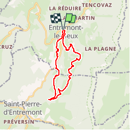
14.4 km | 27 km-effort
5h 27min
Yes
Trail Walking Sainte-Marie-du-Mont - Les Belles Ombres - Sangle et Rochers - Sainte Marie du Mont - Photo
Walking
tracegps

Walking

Medium
(1)
Sainte-Marie-du-Mont, Auvergne-Rhône-Alpes, Isère, France
8.6 km | 16.2 km-effort
5h 0min
Yes
Trail Walking Entremont-le-Vieux - Le Mont Granier par la cheminée de Tencovaz - Photo
Walking
tracegps

Walking

Difficult
(3)
Entremont-le-Vieux, Auvergne-Rhône-Alpes, Savoy, France
9.6 km | 24 km-effort
5h 0min
Yes
Trail Snowshoes Saint-Pierre-d'Entremont - La Croix de l'Alpe depuis les Varvats - Photo
Snowshoes
tracegps

Snowshoes

Medium
(1)
Saint-Pierre-d'Entremont, Auvergne-Rhône-Alpes, Savoy, France
12 km | 24 km-effort
5h 0min
Yes
Trail Walking Chapareillan - Le Granier 1933m, par les pas de la Porte et de Bellecombe - Photo
Walking
tracegps

Walking

Difficult
(1)
Chapareillan, Auvergne-Rhône-Alpes, Isère, France
13.2 km | 30 km-effort
7h 30min
Yes
Trail Walking Saint-Pierre-d'Entremont - Roche Veyrand par les Clapiers, 1429m - Photo
Walking
tracegps

Walking

Difficult
(1)
Saint-Pierre-d'Entremont, Auvergne-Rhône-Alpes, Savoy, France
4.8 km | 14.3 km-effort
4h 10min
Yes
Trail Walking Entremont-le-Vieux - Traversée du Mont Outheran 1676m - Photo
Walking
tracegps

Walking

Difficult
(1)
Entremont-le-Vieux, Auvergne-Rhône-Alpes, Savoy, France
9 km | 15.9 km-effort
3h 30min
Yes
Trail Snowshoes Entremont-le-Vieux - Chartreuse-Des Déserts au col du Mollard - Photo
Snowshoes
patpounet73

Snowshoes

Easy
(1)
Entremont-le-Vieux, Auvergne-Rhône-Alpes, Savoy, France
6.7 km | 9.8 km-effort
2h 26min
Yes
Trail Walking Entremont-le-Vieux - la Plagne le Pinet :en boucle partielle à  partir de la bifurcation GR9 et montée au Pinet - Photo
Walking
Valgaudemar

Walking

Medium
Entremont-le-Vieux, Auvergne-Rhône-Alpes, Savoy, France
12.9 km | 24 km-effort
3h 39min
Yes


Close
My subscriptions