Trail Walking Peynier - De Peynier aux ruines de Dalbessy - Photo

De Peynier aux ruines de Dalbessy

 ARPF
ARPF

User

© OpenStreetMap contributors
Length
Length
8 km
Max alt
Max alt
440 m
Uphill gradient
Uphill gradient
191 m
Km-Effort
Km-Effort  
10.6 km
Min alt
Min alt
273 m
Downhill gradient
Downhill gradient
196 m
Boucle
Boucle
Yes
Creation date :
2018-06-26 14:52:48.541
Updated on :
2018-06-26 14:52:48.541

(1 Reviews)

Walking
Walking
2h16
Difficulty : Medium

Scan this QR Code to open this trail in the SityTrail application

FREE GPS app for hiking

Logo SityTrail SityTrail

IGN / Geographical institutes

Download SityTrail from the App Store Download SityTrail from Google Play

Logo SityTrail SityTrail World

The world is yours!

Download SityTrail from the App Store Download SityTrail from Google Play Download SityTrail on Huawei AppGallery

About

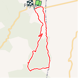
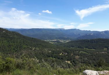
Trail Walking of 8 km to be discovered at Provence-Alpes-Côte d'Azur, Bouches-du-Rhône, Peynier. This trail is proposed by ARPF.

Description

P1 T1 Philippe & Claire 1/2 journée reco du 25/05/2018
Copiée sur Carnoux.

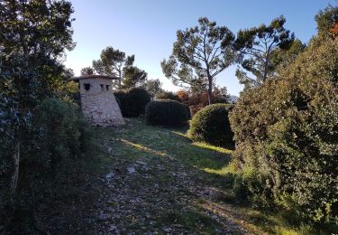
La première moitié du parcours se fait sur une piste DFCI. A partir de la cote 401,prendre à gauche et retour par un petit chemin très agréable. Retrouvez d’autres informations sur le site de Rando Loisirs à Carnoux en Provence.

Elevation profile

Photos

Points of interest

Positioning

Country:
France
Region :
Provence-Alpes-Côte d'Azur
Department/Province :
Bouches-du-Rhône
Municipality :
Peynier
Location:
Unknown
Start:(UTM)
713782 ; 4813664 (31T) N.

Comments

Please log in to post a review or rate the element


Trails nearby

Trail Mountain bike Trets - les contreforts du mont Olympe - Photo
Mountain bike
GUIDE
amiral13

Mountain bike

Easy
(1)
Trets, Provence-Alpes-Côte d'Azur, Bouches-du-Rhône, France
11.8 km | 15.5 km-effort
2h 52min
Yes
Trail Walking Peynier - De Peynier aux ruines de Dalbessy - Photo
Walking
tracegps

Walking

Medium
(2)
Peynier, Provence-Alpes-Côte d'Azur, Bouches-du-Rhône, France
8 km | 10.6 km-effort
2h 0min
Yes
Trail Walking Peynier - Belcodène - Puit de l'Auris - Les Michels - Photo
Walking
tracegps

Walking

Medium
(2)
Peynier, Provence-Alpes-Côte d'Azur, Bouches-du-Rhône, France
10.9 km | 13.9 km-effort
2h 30min
Yes
Trail Mountain bike Peynier - 2022-07-01_16h28m10_regagnasx3_30k737d - Photo
Mountain bike
eloi13

Mountain bike

Difficult
(1)
Peynier, Provence-Alpes-Côte d'Azur, Bouches-du-Rhône, France
30 km | 40 km-effort
2h 46min
Yes
Trail On foot Belcodène - la Grotte du tonneau belcodene - Photo
On foot
Coryphene

On foot

Medium
(1)
Belcodène, Provence-Alpes-Côte d'Azur, Bouches-du-Rhône, France
9.1 km | 12.2 km-effort
Unknown
Yes
Trail Walking Belcodène - boucle de l'Agache - Photo
Walking
GUIDE
amiral13

Walking

Very easy
(1)
Belcodène, Provence-Alpes-Côte d'Azur, Bouches-du-Rhône, France
4.6 km | 5.7 km-effort
1h 11min
Yes
Trail Mountain bike Belcodène - la montagne de Régagnas - Photo
Mountain bike
GUIDE
amiral13

Mountain bike

Medium
(1)
Belcodène, Provence-Alpes-Côte d'Azur, Bouches-du-Rhône, France
15.7 km | 20 km-effort
3h 27min
Yes
Trail Walking Trets - Sentier des vignes Trets - Photo
Walking
Elidabeth

Walking

Medium
(1)
Trets, Provence-Alpes-Côte d'Azur, Bouches-du-Rhône, France
13.2 km | 16.9 km-effort
2h 55min
Yes
Trail Walking Peynier - le tour du garri de claude - Photo
Walking
Coryphene

Walking

Difficult
(1)
Peynier, Provence-Alpes-Côte d'Azur, Bouches-du-Rhône, France
9 km | 12 km-effort
2h 43min
Yes


Close
My subscriptions