Randonnée Marche Barr - Les trois châteaux sur les hauteurs de Barr - Photo

Les trois châteaux sur les hauteurs de Barr

 VacheKiri67
VacheKiri67

Utilisateur

© OpenStreetMap contributors
Longueur
Longueur
16,8 km
Altitude max
Altitude max
587 m
Dénivelé positif
Dénivelé positif
651 m
Km-Effort
Km-Effort  
25 km
Altitude min
Altitude min
208 m
Dénivelé négatif
Dénivelé négatif
651 m
Boucle
Boucle
Oui
Date de création :
2018-04-16 21:41:04.467
Dernière modification :
2018-04-16 21:41:04.467

(2 Avis)

Marche
Marche
5h02
Difficulté : Difficile

Scannez ce code QR pour ouvrir la randonnée dans l'application SityTrail

Application GPS de randonnée GRATUITE

Logo SityTrail SityTrail

IGN / Instituts géographiques

Télécharger SityTrail sur l'App Store Télécharger SityTrail sur Google Play

Logo SityTrail SityTrail World

Le monde est à vous

Télécharger SityTrail sur l'App Store Télécharger SityTrail sur Google Play Télécharger SityTrail sur Huawei AppGallery

À propos

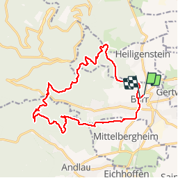
Randonnée Marche de 16,8 km à découvrir à Grand Est, Bas-Rhin, Barr. Cette randonnée est proposée par VacheKiri67.

Description

Faite le 20/08/2017 avec notre fils Théo de 12 ans. D'après "Passion Vosges - Autour du Mont Sainte-Odile" N°16 : Les trois châteaux sur les hauteurs de Barr. Durée indiquée pour le circuit : 5h.

Profil altimétrique

Photos

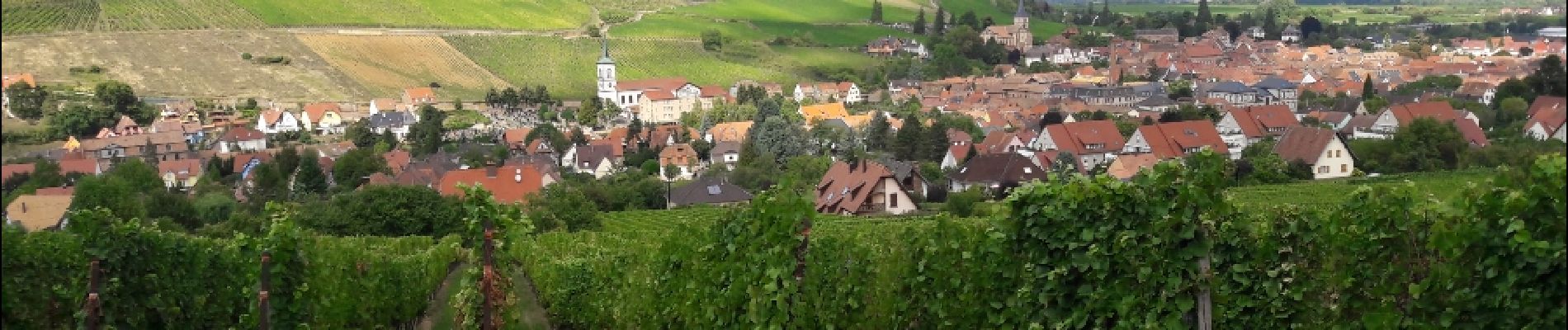
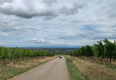
24 photos au total. Cliquez sur une photo pour les afficher toutes dans la galerie.

Localisation

Pays :
France
Région :
Grand Est
Département/Province :
Bas-Rhin
Commune :
Barr
Localité :
Unknown
Départ:(Dec)
Départ:(UTM)
385417 ; 5363065 (32U) N.

Commentaires

Veuillez vous connecter pour laisser un commentaire ou une note


Randonnées à proximité

Randonnée Marche Ottrott - Le circuit sud du Mur Païen - Photo
Marche
VacheKiri67

Marche

Facile
(2)
Ottrott, Grand Est, Bas-Rhin, France
4,9 km | 6,3 km-effort
1h 56min
Non
Randonnée Marche Ottrott - Le circuit nord du Mur Païen - Photo
Marche
VacheKiri67

Marche

Facile
(1)
Ottrott, Grand Est, Bas-Rhin, France
5,9 km | 8,5 km-effort
2h 4min
Non
Randonnée Marche Andlau - Depuis Andlau vers le village viticole de Mittelbergheim - Photo
Marche
VacheKiri67

Marche

Moyen
(1)
Andlau, Grand Est, Bas-Rhin, France
11,9 km | 15,9 km-effort
4h 3min
Oui
Randonnée Marche Ottrott - Le mur païen - Photo
Marche
VacheKiri67

Marche

Moyen
(4)
Ottrott, Grand Est, Bas-Rhin, France
10,5 km | 14,5 km-effort
4h 36min
Oui
Randonnée Marche Ottrott - Mur Paien complet - Photo
Marche
markrei

Marche

Moyen
(1)
Ottrott, Grand Est, Bas-Rhin, France
12 km | 16,4 km-effort
5h 25min
Oui
Randonnée V.T.T. Barr - Circuit des 3 Petits Ponts - Photo
V.T.T.
tracegps

V.T.T.

Difficile
(1)
Barr, Grand Est, Bas-Rhin, France
15,9 km | 22 km-effort
1h 19min
Oui
Randonnée Marche Obernai - sentier des merveilles - Photo
Marche
semila

Marche

Difficile
(1)
Obernai, Grand Est, Bas-Rhin, France
11 km | 16,6 km-effort
4h 8min
Oui
Randonnée Marche Mittelbergheim - Mittelbergheim - Château du Landsberg - Photo
Marche
tracegps

Marche

Moyen
(3)
Mittelbergheim, Grand Est, Bas-Rhin, France
15,4 km | 23 km-effort
5h 0min
Oui
Randonnée Marche Goxwiller - Goxwiller-Landsberg-Kapellenhausfelsen-Goxwiller - Photo
Marche
Silke Roth

Marche

Moyen
Goxwiller, Grand Est, Bas-Rhin, France
17,7 km | 26 km-effort
4h 30min
Non


Fermer
Mes abonnements