Randonnée Marche Stavelot - xtrail stavelot 13 km - Photo

xtrail stavelot 13 km

 Vincentstephane
Vincentstephane

Utilisateur

© OpenStreetMap contributors
Longueur
Longueur
13,5 km
Altitude max
Altitude max
510 m
Dénivelé positif
Dénivelé positif
473 m
Km-Effort
Km-Effort  
19,8 km
Altitude min
Altitude min
284 m
Dénivelé négatif
Dénivelé négatif
472 m
Boucle
Boucle
Oui
Date de création :
2018-04-17 20:49:10.117
Dernière modification :
2018-04-17 20:49:10.117

(0 Avis)

Marche
Marche
3h12
Difficulté : Moyen

Scannez ce code QR pour ouvrir la randonnée dans l'application SityTrail

Application GPS de randonnée GRATUITE

Logo SityTrail SityTrail

IGN / Instituts géographiques

Télécharger SityTrail sur l'App Store Télécharger SityTrail sur Google Play

Logo SityTrail SityTrail World

Le monde est à vous

Télécharger SityTrail sur l'App Store Télécharger SityTrail sur Google Play Télécharger SityTrail sur Huawei AppGallery

À propos

Randonnée Marche de 13,5 km à découvrir à Wallonie, Liège, Stavelot. Cette randonnée est proposée par Vincentstephane.

Description

Superbe randos vallonnée,beaux panoramas

Profil altimétrique

Localisation

Pays :
Belgique
Région :
Wallonie
Département/Province :
Liège
Commune :
Stavelot
Localité :
Stavelot
Départ:(Dec)
Départ:(UTM)
708306 ; 5586469 (31U) N.

Randonnées à proximité

Randonnée Marche Trois-Ponts - RB-Lg-29_Wanne - Photo
Marche
PRO

Marche

Très difficile
(5)
Trois-Ponts, Wallonie, Liège, Belgique
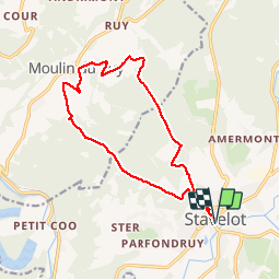
22 km | 29 km-effort
6h 9min
Oui
Randonnée Marche Trois-Ponts - RB-Lg-27_Trois-Ponts - Photo
Marche
PRO

Marche

Très difficile
(7)
Trois-Ponts, Wallonie, Liège, Belgique
23 km | 33 km-effort
6h 58min
Oui
Randonnée Marche Stavelot - Extratrail_stavelot_13km_new - Photo
Marche
GUIDE
mumu.larandonneuse

Marche

Moyen
(2)
Stavelot, Wallonie, Liège, Belgique
13,4 km | 19,8 km-effort
4h 30min
Oui
Randonnée Marche Stavelot - Stavelot  - Photo
Marche
GUIDE
mumu.larandonneuse

Marche

Difficile
(3)
Stavelot, Wallonie, Liège, Belgique
18,8 km | 26 km-effort
5h 53min
Non
Randonnée Marche Trois-Ponts - RB-Lg-29_Wanne_via-racc-2 - Photo
Marche
PRO

Marche

Très difficile
(3)
Trois-Ponts, Wallonie, Liège, Belgique
14,2 km | 19,2 km-effort
4h 21min
Oui
Randonnée Marche Trois-Ponts - RB-Lg-27_Trois-Ponts_via-racc - Photo
Marche
PRO

Marche

Très difficile
(1)
Trois-Ponts, Wallonie, Liège, Belgique
17 km | 25 km-effort
5h 12min
Oui
Randonnée Marche Stavelot - Chemin des Sources |étape n°3  STAVELOT – HOCKAI - Photo
Marche
PRO

Marche

Très difficile
(1)
Stavelot, Wallonie, Liège, Belgique
19 km | 25 km-effort
5h 45min
Non
Randonnée Trail Stavelot - Extra Trail - Stavelot (rouge) 23km - Photo
Trail
PRO

Trail

Très difficile
(1)
Stavelot, Wallonie, Liège, Belgique
23 km | 35 km-effort
Inconnu
Oui
Randonnée Trail Stavelot - Extra Trail - Stavelot (bleu) 13km - Photo
Trail
PRO

Trail

Difficile
(1)
Stavelot, Wallonie, Liège, Belgique
13,4 km | 19,5 km-effort
Inconnu
Oui


Fermer
Mes abonnements