


GR 4 (2)

chasle
Gebruiker

Lengte
16,2 km

Max. hoogte
1519 m

Positief hoogteverschil
1014 m
Km-Effort
31 km

Min. hoogte
452 m

Negatief hoogteverschil
1320 m
Boucle
Neen
Datum van aanmaak :
2019-01-16 00:02:11.2
Laatste wijziging :
2019-01-16 00:02:47.428
5h58
Moeilijkheid : Zeer moeilijk

Gratisgps-wandelapplicatie
 SityTrail
IGN / Geografische instituten
SityTrail Plus
De wereld gaat voor u open
Over ons
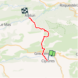
Tocht Stappen van 16,2 km beschikbaar op Provence-Alpes-Côte d'Azur, Alpes-Maritimes, Cipières. Deze tocht wordt voorgesteld door chasle.
Plaatsbepaling
Land:
France
Regio :
Provence-Alpes-Côte d'Azur
Departement/Provincie :
Alpes-Maritimes
Gemeente :
Cipières
Locatie:
Unknown
Vertrek:(Dec)
Vertrek:(UTM)
335469 ; 4849927 (32T) N.
Opmerkingen