


Rouelles Parc

DDLEDANDY
Gebruiker

Lengte
7,4 km

Max. hoogte
85 m

Positief hoogteverschil
173 m
Km-Effort
9,7 km

Min. hoogte
2 m

Negatief hoogteverschil
179 m
Boucle
Ja
Datum van aanmaak :
2020-09-18 08:36:56.799
Laatste wijziging :
2020-09-18 10:10:33.035
1h33
Moeilijkheid : Heel gemakkelijk

Gratisgps-wandelapplicatie
 SityTrail
IGN / Geografische instituten
SityTrail Plus
De wereld gaat voor u open
Over ons
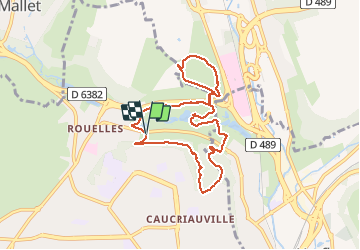
Tocht Stappen van 7,4 km beschikbaar op Normandië, Seine-Maritime, Le Havre. Deze tocht wordt voorgesteld door DDLEDANDY.
Plaatsbepaling
Land:
France
Regio :
Normandië
Departement/Provincie :
Seine-Maritime
Gemeente :
Le Havre
Locatie:
Unknown
Vertrek:(Dec)
Vertrek:(UTM)
295142 ; 5489215 (31U) N.
Opmerkingen