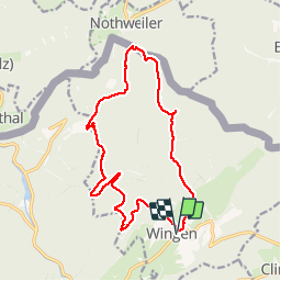
Tocht Stappen Wingen - 67 WINGEN  GIMBELHOF - Photo

67 WINGEN GIMBELHOF

 LUTZMarc
LUTZMarc

Gebruiker

© OpenStreetMap contributors
Lengte
Lengte
15,8 km
Max. hoogte
Max. hoogte
490 m
Positief hoogteverschil
488 m
Km-Effort
Km-Effort  
22 km
Min. hoogte
Min. hoogte
268 m
Negatief hoogteverschil
489 m
Boucle
Boucle
Ja
Datum van aanmaak :
2018-04-17 15:38:29.506
Laatste wijziging :
2018-04-17 15:38:29.506

(1 Bericht)

Stappen
Stappen
4h14
Moeilijkheid : Gemakkelijk

Scan deze QR-code om de tocht te openen in de SityTrail-applicatie

Gratisgps-wandelapplicatie

Logo SityTrail SityTrail

IGN / Geografische instituten

SityTrail uit de App Store downloaden SityTrail uit Google Play downloaden

Logo SityTrail SityTrail Plus

De wereld gaat voor u open

SityTrail uit de App Store downloaden SityTrail uit Google Play downloaden SityTrail op Huawei AppGallery downloaden

Over ons

Tocht Stappen van 15,8 km beschikbaar op Grand Est, Bas-Rhin, Wingen. Deze tocht wordt voorgesteld door LUTZMarc.

Beschrijving

Belle rando dans les Vosges du nord.
Terrain sablonneux, praticable en tout temps.
Resto possible â l'Hotel Restaurant du Gimbelhof.
Ferme du Froensbourg,
67510 Lembach
Tel 03 88 94 43 58

Pensez à  réserver, c'est très fréquenté surtout le dimanche.

Hoogteprofiel

Plaatsbepaling

Land:
France
Regio :
Grand Est
Departement/Provincie :
Bas-Rhin
Gemeente :
Wingen
Locatie:
Unknown
Vertrek:(Dec)
Vertrek:(UTM)
413376 ; 5430946 (32U) N.

Opmerkingen

Gelieve in te loggen om een commentaar of een beoordeling achter te laten


Sluiten
Mijn abonnementen