![](/images/other/stat-length.png)
![Tour Mountainbike Pruillé-le-Chétif - Saint George du Bois - Pruillé le Chétif - Photo](https://media.geolcdn.com/t/1900/400/ext.pjpeg?maxdim=2&url=https%3A%2F%2Fstatic1.geolcdn.com%2Fsiteimages%2Fupload%2Ffiles%2F1524743154velo.jpg)
Saint George du Bois - Pruillé le Chétif
tracegps
Benutzer
![Länge](/images/other/stat-length.png)
Länge
21 km
![Maximale Höhe](https://static1.geolcdn.com/siteimages/upload/files/1508320355ic_sort_altitude_max_24dp.png)
Maximale Höhe
119 m
![Positive Höhendifferenz](https://static1.geolcdn.com/siteimages/upload/files/1508320355ic_sort_den_pos_24dp.png)
Positive Höhendifferenz
273 m
![Km-Effort](/images/other/stat-length.png)
Km-Effort
24 km
![Min. Höhe](https://static1.geolcdn.com/siteimages/upload/files/1508320355ic_sort_altitude_min_24dp.png)
Min. Höhe
57 m
![Negative Höhendifferenz](https://static1.geolcdn.com/siteimages/upload/files/1508320355ic_sort_den_neg_24dp.png)
Negative Höhendifferenz
273 m
![Boucle](https://static1.geolcdn.com/siteimages/upload/files/16400158638029165_repeat_loop_refresh_sync_direction_icon.png)
Boucle
Ja
Erstellungsdatum :
2014-12-10 00:00:00.0
Letzte Änderung :
2014-12-10 00:00:00.0
![Mountainbike](https://static1.geolcdn.com/sitytour/trail-icons/202.png)
1h30
Schwierigkeit : Medium
![Scannen Sie diesen QR-Code, um die Tour in der SityTrail-Anwendung zu öffnen](https://capi.geolives.com/qq0zvz2zws4bq2lad0pu/sitytour/trails/104232/qr.png?size=200)
Kostenlosegpshiking-Anwendung
Über SityTrail
Tour Mountainbike von 21 km verfügbar auf Pays de la Loire, Sarthe, Pruillé-le-Chétif. Diese Tour wird von tracegps vorgeschlagen.
Beschreibung
Petite balade en foret, facile d'accès, en chemin carrossable la plupart du temps. Agréable et bien pour se dégourdir les jambes.
Ort
Land:
France
Region :
Pays de la Loire
Abteilung/Provinz :
Sarthe
Kommune :
Pruillé-le-Chétif
Standort:
Unknown
Gehen Sie:(Dec)
Gehen Sie:(UTM)
285814 ; 5319142 (31T) N.
Kommentare
Touren in der Umgebung
![Tour Mountainbike Arnage - Raid arche nature 5 avril 2014 - Photo](https://media.geolcdn.com/t/375/260/ext.jpg?maxdim=2&url=https%3A%2F%2Fstatic1.geolcdn.com%2Fsiteimages%2Fupload%2Ffiles%2F1524743154velo.jpg)
![Mountainbike Mountainbike](https://static1.geolcdn.com/sitytour/trail-icons/202.png)
Raid arche nature 5 avril 2014
Mountainbike
Schwierig
(1)
Arnage,
Pays de la Loire,
Sarthe,
France
![](/images/other/stat-length.png)
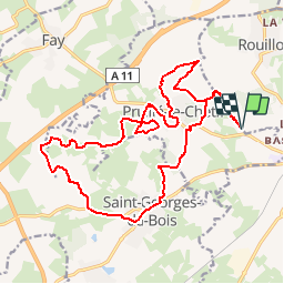
69 km | 81 km-effort
Unbekannt
![](https://static1.geolcdn.com/siteimages/upload/files/16400158638029165_repeat_loop_refresh_sync_direction_icon.png)
Nein
![Tour Zu Fuß Rouillon - Chemin Jaune - Photo](https://media.geolcdn.com/t/375/260/ext.jpg?maxdim=2&url=https%3A%2F%2Fmedia.geolcdn.com%2Ff%2Ffe3120b7-7867-4117-8271-e1aec357711a.jpeg)
![Zu Fuß Zu Fuß](https://static1.geolcdn.com/sitytour/trail-icons/100.png)
Chemin Jaune
Zu Fuß
Einfach
Rouillon,
Pays de la Loire,
Sarthe,
France
![](/images/other/stat-length.png)
3,8 km | 4,4 km-effort
59min
![](https://static1.geolcdn.com/siteimages/upload/files/16400158638029165_repeat_loop_refresh_sync_direction_icon.png)
Ja
![Tour Wandern Allonnes - Moulin de Chaoué - Photo](https://media.geolcdn.com/t/375/260/ext.jpg?maxdim=2&url=https%3A%2F%2Fmedia.geolcdn.com%2Ff%2F3a0dcb94-8aa6-43b8-a629-73c6d3af9cac.jpg)
![Wandern Wandern](https://static1.geolcdn.com/sitytour/trail-icons/101.png)
Moulin de Chaoué
Wandern
Sehr leicht
Allonnes,
Pays de la Loire,
Sarthe,
France
![](/images/other/stat-length.png)
9,1 km | 10,3 km-effort
2h 27min
![](https://static1.geolcdn.com/siteimages/upload/files/16400158638029165_repeat_loop_refresh_sync_direction_icon.png)
Ja
![Tour Nordic Walking Pruillé-le-Chétif - SityTrail - Pruillé-le-Chétif - Photo](https://media.geolcdn.com/t/375/260/ext.jpg?maxdim=2&url=https%3A%2F%2Fstatic1.geolcdn.com%2Fsiteimages%2Fupload%2Ffiles%2F1545311037marcheuse_200dpi.jpg)
![Nordic Walking Nordic Walking](https://static1.geolcdn.com/sitytour/trail-icons/102.png)
SityTrail - Pruillé-le-Chétif
Nordic Walking
Sehr leicht
Pruillé-le-Chétif,
Pays de la Loire,
Sarthe,
France
![](/images/other/stat-length.png)
10,9 km | 12,9 km-effort
Unbekannt
![](https://static1.geolcdn.com/siteimages/upload/files/16400158638029165_repeat_loop_refresh_sync_direction_icon.png)
Ja
![Tour Mountainbike Rouillon - bd nature le mans - Photo](https://media.geolcdn.com/t/375/260/ext.jpg?maxdim=2&url=https%3A%2F%2Fstatic1.geolcdn.com%2Fsiteimages%2Fupload%2Ffiles%2F1524743154velo.jpg)
![Mountainbike Mountainbike](https://static1.geolcdn.com/sitytour/trail-icons/202.png)
bd nature le mans
Mountainbike
Einfach
(1)
Rouillon,
Pays de la Loire,
Sarthe,
France
![](/images/other/stat-length.png)
74 km | 84 km-effort
7h 14min
![](https://static1.geolcdn.com/siteimages/upload/files/16400158638029165_repeat_loop_refresh_sync_direction_icon.png)
Nein
![Tour Hybrid-Bike Rouillon - rouillon la guierche boucle - Photo](https://media.geolcdn.com/t/375/260/ext.jpg?maxdim=2&url=https%3A%2F%2Fstatic1.geolcdn.com%2Fsiteimages%2Fupload%2Ffiles%2F1524743154velo.jpg)
![Hybrid-Bike Hybrid-Bike](https://static1.geolcdn.com/sitytour/trail-icons/203.png)
rouillon la guierche boucle
Hybrid-Bike
Einfach
Rouillon,
Pays de la Loire,
Sarthe,
France
![](/images/other/stat-length.png)
44 km | 51 km-effort
3h 0min
![](https://static1.geolcdn.com/siteimages/upload/files/16400158638029165_repeat_loop_refresh_sync_direction_icon.png)
Ja
![Tour Wandern Allonnes - randonnée à pied - Photo](https://media.geolcdn.com/t/375/260/ext.jpg?maxdim=2&url=https%3A%2F%2Fstatic1.geolcdn.com%2Fsiteimages%2Fupload%2Ffiles%2F1553511878bg_sport_marche.png)
![Wandern Wandern](https://static1.geolcdn.com/sitytour/trail-icons/101.png)
randonnée à pied
Wandern
Sehr leicht
Allonnes,
Pays de la Loire,
Sarthe,
France
![](/images/other/stat-length.png)
6,1 km | 7 km-effort
1h 13min
![](https://static1.geolcdn.com/siteimages/upload/files/16400158638029165_repeat_loop_refresh_sync_direction_icon.png)
Ja
![Tour Laufen Trangé - Trangé - Photo](https://media.geolcdn.com/t/375/260/ext.jpg?maxdim=2&url=https%3A%2F%2Fstatic1.geolcdn.com%2Fsiteimages%2Fupload%2Ffiles%2F1524743154running.jpg)
![Laufen Laufen](https://static1.geolcdn.com/sitytour/trail-icons/103.png)
![Tour Wandern Le Mans - Le parc de l'île aux planches - Photo](https://media.geolcdn.com/t/375/260/ext.jpg?maxdim=2&url=https%3A%2F%2Fservices.sitytrail.com%2FGeolivesWS%2FDownloadMedia.ashx%3FTrailID%3D534661%26Media%3Dfix__20160307124741.jpg)
![Wandern Wandern](https://static1.geolcdn.com/sitytour/trail-icons/101.png)
Le parc de l'île aux planches
Wandern
Sehr leicht
(1)
Le Mans,
Pays de la Loire,
Sarthe,
France
![](/images/other/stat-length.png)
2,9 km | 3,2 km-effort
42min
![](https://static1.geolcdn.com/siteimages/upload/files/16400158638029165_repeat_loop_refresh_sync_direction_icon.png)
Ja
Belle ballade 50 m avant départ un parking possible sur D50