![](/images/other/stat-length.png)
The Grande Champagne away from beaten track
Relais-Saint-Preuil
Benutzer
![Länge](/images/other/stat-length.png)
Länge
53 km
![Maximale Höhe](https://static1.geolcdn.com/siteimages/upload/files/1508320355ic_sort_altitude_max_24dp.png)
Maximale Höhe
148 m
![Positive Höhendifferenz](https://static1.geolcdn.com/siteimages/upload/files/1508320355ic_sort_den_pos_24dp.png)
Positive Höhendifferenz
755 m
![Km-Effort](/images/other/stat-length.png)
Km-Effort
63 km
![Min. Höhe](https://static1.geolcdn.com/siteimages/upload/files/1508320355ic_sort_altitude_min_24dp.png)
Min. Höhe
35 m
![Negative Höhendifferenz](https://static1.geolcdn.com/siteimages/upload/files/1508320355ic_sort_den_neg_24dp.png)
Negative Höhendifferenz
755 m
![Boucle](https://static1.geolcdn.com/siteimages/upload/files/16400158638029165_repeat_loop_refresh_sync_direction_icon.png)
Boucle
Ja
Erstellungsdatum :
2014-12-10 00:00:00.0
Letzte Änderung :
2014-12-10 00:00:00.0
![Motor](https://static1.geolcdn.com/sitytour/trail-icons/400.png)
2h40
Schwierigkeit : Medium
![Scannen Sie diesen QR-Code, um die Tour in der SityTrail-Anwendung zu öffnen](https://capi.geolives.com/qq0zvz2zws4bq2lad0pu/sitytour/trails/208592/qr.png?size=200)
Kostenlosegpshiking-Anwendung
Über SityTrail
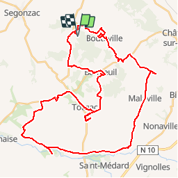
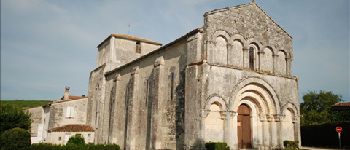
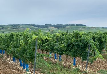
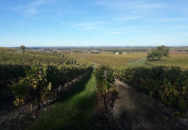
Tour Motor von 53 km verfügbar auf Neu-Aquitanien, Charente, Saint-Preuil. Diese Tour wird von Relais-Saint-Preuil vorgeschlagen.
Beschreibung
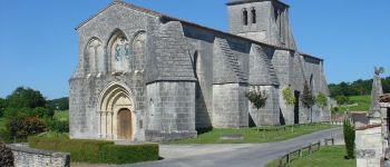
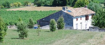
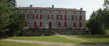
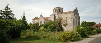
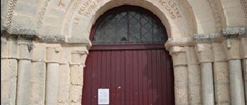
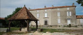
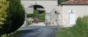
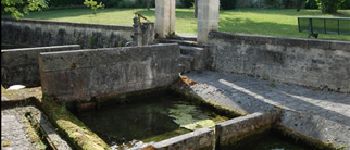
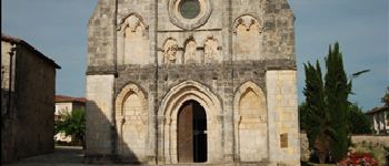
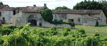
This route from the Relais is an invitation to visit the Grande Champagne vineyards off the beaten track to discover its history, its architecture, its remarkable landscape.
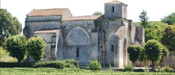
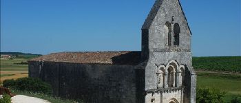
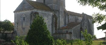
POIs
Ort
Land:
France
Region :
Neu-Aquitanien
Abteilung/Provinz :
Charente
Kommune :
Saint-Preuil
Standort:
Unknown
Gehen Sie:(Dec)
Gehen Sie:(UTM)
721298 ; 5053616 (30T) N.
Kommentare
Touren in der Umgebung
![Tour Wandern Bouteville - Bouteville : Sentier des Chaumes Boissieres - Photo](https://media.geolcdn.com/t/375/260/ext.jpg?maxdim=2&url=https%3A%2F%2Fmedia.geolcdn.com%2Ff%2F22055ec8-b5fa-40ee-abea-89a1ac4873e0.jpg)
![Wandern Wandern](https://static1.geolcdn.com/sitytour/trail-icons/101.png)
Bouteville : Sentier des Chaumes Boissieres
Wandern
Bouteville,
Neu-Aquitanien,
Charente,
France
![](/images/other/stat-length.png)
7,7 km | 9,1 km-effort
1h 53min
![](https://static1.geolcdn.com/siteimages/upload/files/16400158638029165_repeat_loop_refresh_sync_direction_icon.png)
Ja
![Tour Wandern Bouteville - Bouteville (16120) - Photo](https://media.geolcdn.com/t/375/260/ext.jpg?maxdim=2&url=https%3A%2F%2Fservices.sitytrail.com%2FGeolivesWS%2FDownloadMedia.ashx%3FTrailID%3D815803%26Media%3D20170823110116.jpg)
![Wandern Wandern](https://static1.geolcdn.com/sitytour/trail-icons/101.png)
Bouteville (16120)
Wandern
Einfach
Bouteville,
Neu-Aquitanien,
Charente,
France
![](/images/other/stat-length.png)
14,5 km | 17,6 km-effort
3h 49min
![](https://static1.geolcdn.com/siteimages/upload/files/16400158638029165_repeat_loop_refresh_sync_direction_icon.png)
Ja
![Tour Quad Lignières-Sonneville - ssv cognac - Photo](https://media.geolcdn.com/t/375/260/ext.jpg?maxdim=2&url=https%3A%2F%2Fmedia.geolcdn.com%2Ff%2F0da63806-2eba-477b-b28f-2a4320bc81b4.jpg)
![Quad Quad](https://static1.geolcdn.com/sitytour/trail-icons/404.png)
ssv cognac
Quad
Medium
Lignières-Sonneville,
Neu-Aquitanien,
Charente,
France
![](/images/other/stat-length.png)
83 km | 97 km-effort
3h 46min
![](https://static1.geolcdn.com/siteimages/upload/files/16400158638029165_repeat_loop_refresh_sync_direction_icon.png)
Ja
![Tour Wandern Saint-Preuil - Circuit des fontaines et des lavoirs - Variante balisage Violet - Photo](https://media.geolcdn.com/t/375/260/ext.jpg?maxdim=2&url=https%3A%2F%2Fmedia.geolcdn.com%2Ff%2Ff1f3706f-d2ca-4f73-9e3d-f6e9753eb3cc.jpg)
![Wandern Wandern](https://static1.geolcdn.com/sitytour/trail-icons/101.png)
Circuit des fontaines et des lavoirs - Variante balisage Violet
Wandern
Medium
Saint-Preuil,
Neu-Aquitanien,
Charente,
France
![](/images/other/stat-length.png)
12,8 km | 15,5 km-effort
3h 30min
![](https://static1.geolcdn.com/siteimages/upload/files/16400158638029165_repeat_loop_refresh_sync_direction_icon.png)
Ja
![Tour Nordic Walking Lignières-Sonneville - Lignières Sonneville - Photo](https://media.geolcdn.com/t/375/260/ext.jpg?maxdim=2&url=https%3A%2F%2Fstatic1.geolcdn.com%2Fsiteimages%2Fupload%2Ffiles%2F1545311037marcheuse_200dpi.jpg)
![Nordic Walking Nordic Walking](https://static1.geolcdn.com/sitytour/trail-icons/102.png)
Lignières Sonneville
Nordic Walking
Einfach
Lignières-Sonneville,
Neu-Aquitanien,
Charente,
France
![](/images/other/stat-length.png)
14,4 km | 17,7 km-effort
3h 17min
![](https://static1.geolcdn.com/siteimages/upload/files/16400158638029165_repeat_loop_refresh_sync_direction_icon.png)
Ja
![Tour Wandern Mainxe-Gondeville - mainxe - Photo](https://media.geolcdn.com/t/375/260/ext.jpg?maxdim=2&url=https%3A%2F%2Fstatic1.geolcdn.com%2Fsiteimages%2Fupload%2Ffiles%2F1553511878bg_sport_marche.png)
![Wandern Wandern](https://static1.geolcdn.com/sitytour/trail-icons/101.png)
mainxe
Wandern
Sehr leicht
Mainxe-Gondeville,
Neu-Aquitanien,
Charente,
France
![](/images/other/stat-length.png)
12,5 km | 14 km-effort
2h 50min
![](https://static1.geolcdn.com/siteimages/upload/files/16400158638029165_repeat_loop_refresh_sync_direction_icon.png)
Ja
![Tour Wandern Angeac-Charente - les indiens - Photo](https://media.geolcdn.com/t/375/260/ext.jpg?maxdim=2&url=https%3A%2F%2Fstatic1.geolcdn.com%2Fsiteimages%2Fupload%2Ffiles%2F1553511878bg_sport_marche.png)
![Wandern Wandern](https://static1.geolcdn.com/sitytour/trail-icons/101.png)
les indiens
Wandern
Sehr leicht
Angeac-Charente,
Neu-Aquitanien,
Charente,
France
![](/images/other/stat-length.png)
4,9 km | 5,6 km-effort
1h 33min
![](https://static1.geolcdn.com/siteimages/upload/files/16400158638029165_repeat_loop_refresh_sync_direction_icon.png)
Ja
![Tour Wandern Saint-Preuil - Saint prémilitaire - Photo](https://media.geolcdn.com/t/375/260/ext.jpg?maxdim=2&url=https%3A%2F%2Fstatic1.geolcdn.com%2Fsiteimages%2Fupload%2Ffiles%2F1553511878bg_sport_marche.png)
![Wandern Wandern](https://static1.geolcdn.com/sitytour/trail-icons/101.png)
Saint prémilitaire
Wandern
Saint-Preuil,
Neu-Aquitanien,
Charente,
France
![](/images/other/stat-length.png)
9,2 km | 11,1 km-effort
2h 36min
![](https://static1.geolcdn.com/siteimages/upload/files/16400158638029165_repeat_loop_refresh_sync_direction_icon.png)
Ja
![Tour Wandern Segonzac - Autour de Segonzac - Photo](https://media.geolcdn.com/t/375/260/ext.jpg?maxdim=2&url=https%3A%2F%2Fstatic1.geolcdn.com%2Fsiteimages%2Fupload%2Ffiles%2F1553511878bg_sport_marche.png)
![Wandern Wandern](https://static1.geolcdn.com/sitytour/trail-icons/101.png)
Autour de Segonzac
Wandern
Medium
Segonzac,
Neu-Aquitanien,
Charente,
France
![](/images/other/stat-length.png)
14,6 km | 17,1 km-effort
2h 59min
![](https://static1.geolcdn.com/siteimages/upload/files/16400158638029165_repeat_loop_refresh_sync_direction_icon.png)
Ja