![](/images/other/stat-length.png)
![Tour Wandern Chichilianne - Esclops Trièves Tour du Mont Aiguille - Photo](https://media.geolcdn.com/t/1900/400/ext.pjpeg?maxdim=2&url=https%3A%2F%2Fmedia.geolcdn.com%2Ff%2F367f316d-8d4c-43ed-bbe2-7016bd24ae42.jpg)
Esclops Trièves Tour du Mont Aiguille
TOULAUDIN
Benutzer
![Länge](/images/other/stat-length.png)
Länge
16,6 km
![Maximale Höhe](https://static1.geolcdn.com/siteimages/upload/files/1508320355ic_sort_altitude_max_24dp.png)
Maximale Höhe
1721 m
![Positive Höhendifferenz](https://static1.geolcdn.com/siteimages/upload/files/1508320355ic_sort_den_pos_24dp.png)
Positive Höhendifferenz
1143 m
![Km-Effort](/images/other/stat-length.png)
Km-Effort
32 km
![Min. Höhe](https://static1.geolcdn.com/siteimages/upload/files/1508320355ic_sort_altitude_min_24dp.png)
Min. Höhe
1012 m
![Negative Höhendifferenz](https://static1.geolcdn.com/siteimages/upload/files/1508320355ic_sort_den_neg_24dp.png)
Negative Höhendifferenz
1144 m
![Boucle](https://static1.geolcdn.com/siteimages/upload/files/16400158638029165_repeat_loop_refresh_sync_direction_icon.png)
Boucle
Ja
Erstellungsdatum :
2022-07-01 06:37:31.546
Letzte Änderung :
2022-07-12 15:17:50.16
![Wandern](https://static1.geolcdn.com/sitytour/trail-icons/101.png)
7h38
Schwierigkeit : Schwierig
![Scannen Sie diesen QR-Code, um die Tour in der SityTrail-Anwendung zu öffnen](https://capi.geolives.com/qq0zvz2zws4bq2lad0pu/sitytour/trails/3300931/qr.png?size=200)
Kostenlosegpshiking-Anwendung
Über SityTrail
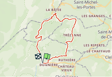
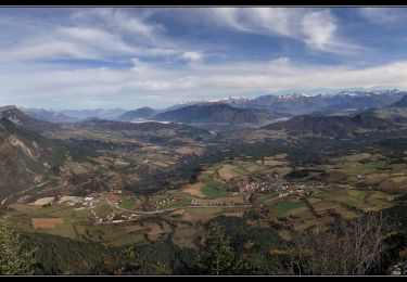
Tour Wandern von 16,6 km verfügbar auf Auvergne-Rhone-Alpen, Isère, Chichilianne. Diese Tour wird von TOULAUDIN vorgeschlagen.
Beschreibung
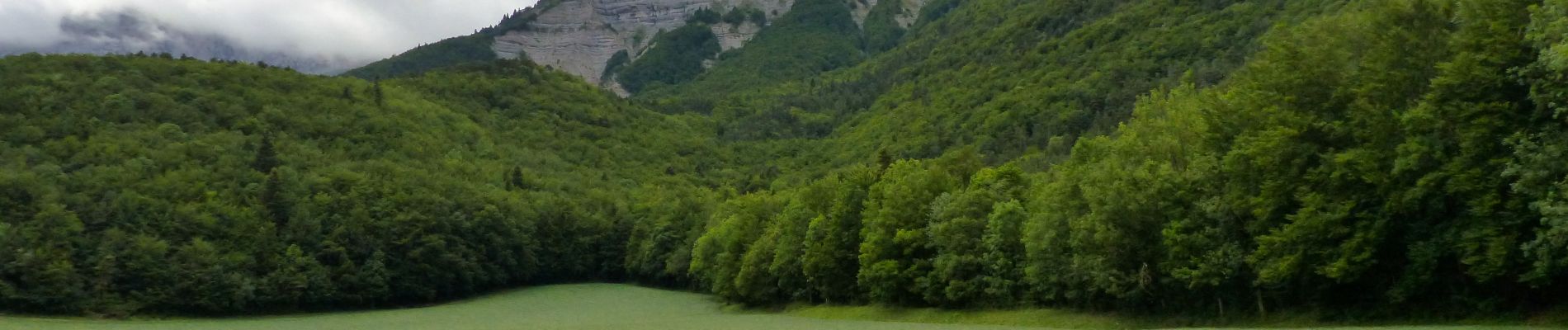
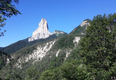
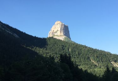
rando effectuée pas temps de brume ,on n'a pas vu le mont aiguille( la veille il avait plu et le terrain était très glissant ...beaucoup de racines)donc à faire plutôt par temps sec.
Ort
Land:
France
Region :
Auvergne-Rhone-Alpen
Abteilung/Provinz :
Isère
Kommune :
Chichilianne
Standort:
Unknown
Gehen Sie:(Dec)
Gehen Sie:(UTM)
701382 ; 4966406 (31T) N.
Kommentare
Touren in der Umgebung
![Tour Wandern Chichilianne - Le Platary - Photo](https://media.geolcdn.com/t/375/260/ext.jpg?maxdim=2&url=https%3A%2F%2Fservices.sitytrail.com%2FGeolivesWS%2FDownloadMedia.ashx%3FTrailID%3D836793%26Media%3Dfix__20170928142121.jpg)
![Wandern Wandern](https://static1.geolcdn.com/sitytour/trail-icons/101.png)
Le Platary
Wandern
Medium
(2)
Chichilianne,
Auvergne-Rhone-Alpen,
Isère,
France
![](/images/other/stat-length.png)
6,6 km | 12,1 km-effort
2h 29min
![](https://static1.geolcdn.com/siteimages/upload/files/16400158638029165_repeat_loop_refresh_sync_direction_icon.png)
Ja
![Tour Wandern Chichilianne - La Fontaine Pourrie - Hauts Plateaux Sud du Vercors - Photo](https://media.geolcdn.com/t/375/260/ext.jpg?maxdim=2&url=https%3A%2F%2Fservices.sitytrail.com%2FGeolivesWS%2FDownloadMedia.ashx%3FTrailID%3D105613%26Media%3D9383_1.jpg)
![Wandern Wandern](https://static1.geolcdn.com/sitytour/trail-icons/101.png)
La Fontaine Pourrie - Hauts Plateaux Sud du Vercors
Wandern
Medium
(2)
Chichilianne,
Auvergne-Rhone-Alpen,
Isère,
France
![](/images/other/stat-length.png)
19,4 km | 33 km-effort
7h 45min
![](https://static1.geolcdn.com/siteimages/upload/files/16400158638029165_repeat_loop_refresh_sync_direction_icon.png)
Ja
![Tour Schneeschuhwandern Chichilianne - chichilianne archiane - Photo](https://media.geolcdn.com/t/375/260/ext.jpg?maxdim=2&url=https%3A%2F%2Fstatic1.geolcdn.com%2Fsiteimages%2Fupload%2Ffiles%2F1524743153raquette.jpg)
![Schneeschuhwandern Schneeschuhwandern](https://static1.geolcdn.com/sitytour/trail-icons/504.png)
chichilianne archiane
Schneeschuhwandern
Medium
(1)
Chichilianne,
Auvergne-Rhone-Alpen,
Isère,
France
![](/images/other/stat-length.png)
18,9 km | 32 km-effort
8h 0min
![](https://static1.geolcdn.com/siteimages/upload/files/16400158638029165_repeat_loop_refresh_sync_direction_icon.png)
Nein
![Tour Wandern Gresse-en-Vercors - Pas des Baschassons - Carrière romaine - Pas de la Selle - Photo](https://media.geolcdn.com/t/375/260/ext.jpg?maxdim=2&url=https%3A%2F%2Fmedia.geolcdn.com%2Ff%2F56b0bd40-9412-42bf-9504-9a813d0bd429.jpg)
![Wandern Wandern](https://static1.geolcdn.com/sitytour/trail-icons/101.png)
Pas des Baschassons - Carrière romaine - Pas de la Selle
Wandern
Schwierig
Gresse-en-Vercors,
Auvergne-Rhone-Alpen,
Isère,
France
![](/images/other/stat-length.png)
16,9 km | 31 km-effort
7h 0min
![](https://static1.geolcdn.com/siteimages/upload/files/16400158638029165_repeat_loop_refresh_sync_direction_icon.png)
Ja
![Tour Wandern Saint-Martin-de-Clelles - Esclops Trièves tour du goutaroux - Photo](https://media.geolcdn.com/t/375/260/ext.jpg?maxdim=2&url=https%3A%2F%2Fmedia.geolcdn.com%2Ff%2F92348273-d153-4731-a4d8-1976f500b0d9.jpg)
![Wandern Wandern](https://static1.geolcdn.com/sitytour/trail-icons/101.png)
Esclops Trièves tour du goutaroux
Wandern
Medium
Saint-Martin-de-Clelles,
Auvergne-Rhone-Alpen,
Isère,
France
![](/images/other/stat-length.png)
11 km | 18,8 km-effort
4h 58min
![](https://static1.geolcdn.com/siteimages/upload/files/16400158638029165_repeat_loop_refresh_sync_direction_icon.png)
Ja
![Tour Zu Fuß Chichilianne - Pas de l'Aiguille - Photo](https://media.geolcdn.com/t/375/260/ext.jpg?maxdim=2&url=https%3A%2F%2Fmedia.geolcdn.com%2Ff%2Fb17edeb4-7e8a-4950-864e-2edc454f1f7c.jpeg)
![Zu Fuß Zu Fuß](https://static1.geolcdn.com/sitytour/trail-icons/100.png)
Pas de l'Aiguille
Zu Fuß
Medium
Chichilianne,
Auvergne-Rhone-Alpen,
Isère,
France
![](/images/other/stat-length.png)
17,1 km | 29 km-effort
6h 39min
![](https://static1.geolcdn.com/siteimages/upload/files/16400158638029165_repeat_loop_refresh_sync_direction_icon.png)
Ja
![Tour Zu Fuß Saint-Martin-de-Clelles - Chemin du Goutaroux - Photo](https://media.geolcdn.com/t/375/260/ext.jpg?maxdim=2&url=https%3A%2F%2Fmedia.geolcdn.com%2Ff%2F9d096ac3-20e2-4285-a876-435f73018545.jpeg)
![Zu Fuß Zu Fuß](https://static1.geolcdn.com/sitytour/trail-icons/100.png)
Chemin du Goutaroux
Zu Fuß
Einfach
Saint-Martin-de-Clelles,
Auvergne-Rhone-Alpen,
Isère,
France
![](/images/other/stat-length.png)
4,2 km | 9,5 km-effort
2h 9min
![](https://static1.geolcdn.com/siteimages/upload/files/16400158638029165_repeat_loop_refresh_sync_direction_icon.png)
Nein
![Tour Wandern Chichilianne - Sommets de Charbonnier & du Platary - Photo](https://media.geolcdn.com/t/375/260/ext.jpg?maxdim=2&url=https%3A%2F%2Fmedia.geolcdn.com%2Ff%2Fcd6d993b-8f70-411d-9b8e-9424ee6be01c.jpg)
![Wandern Wandern](https://static1.geolcdn.com/sitytour/trail-icons/101.png)
Sommets de Charbonnier & du Platary
Wandern
Medium
Chichilianne,
Auvergne-Rhone-Alpen,
Isère,
France
![](/images/other/stat-length.png)
12,1 km | 21 km-effort
5h 24min
![](https://static1.geolcdn.com/siteimages/upload/files/16400158638029165_repeat_loop_refresh_sync_direction_icon.png)
Ja
![Tour Wandern Chichilianne - Autour du mont Aiguille - Photo](https://media.geolcdn.com/t/375/260/ext.jpg?maxdim=2&url=https%3A%2F%2Fmedia.geolcdn.com%2Ff%2Fd491c7d0-84ed-41db-8374-af63ce0edc75.jpg)
![Wandern Wandern](https://static1.geolcdn.com/sitytour/trail-icons/101.png)
Autour du mont Aiguille
Wandern
Schwierig
Chichilianne,
Auvergne-Rhone-Alpen,
Isère,
France
![](/images/other/stat-length.png)
19,6 km | 35 km-effort
6h 48min
![](https://static1.geolcdn.com/siteimages/upload/files/16400158638029165_repeat_loop_refresh_sync_direction_icon.png)
Ja