![](/images/other/stat-length.png)
![Tour Wandern Antoing - PERONNES - LEZ - ANTOING _Marche Fédérale _ HT _ 03/12/2022 - Photo](https://media.geolcdn.com/t/1900/400/ext.pjpeg?maxdim=2&url=https%3A%2F%2Fmedia.geolcdn.com%2Ff%2F74c5a77e-93ee-40e5-88c8-a2bf6ff7ab48.jpg)
PERONNES - LEZ - ANTOING _Marche Fédérale _ HT _ 03/12/2022
jeangulu
Benutzer
![Länge](/images/other/stat-length.png)
Länge
18,4 km
![Maximale Höhe](https://static1.geolcdn.com/siteimages/upload/files/1508320355ic_sort_altitude_max_24dp.png)
Maximale Höhe
45 m
![Positive Höhendifferenz](https://static1.geolcdn.com/siteimages/upload/files/1508320355ic_sort_den_pos_24dp.png)
Positive Höhendifferenz
141 m
![Km-Effort](/images/other/stat-length.png)
Km-Effort
20 km
![Min. Höhe](https://static1.geolcdn.com/siteimages/upload/files/1508320355ic_sort_altitude_min_24dp.png)
Min. Höhe
12 m
![Negative Höhendifferenz](https://static1.geolcdn.com/siteimages/upload/files/1508320355ic_sort_den_neg_24dp.png)
Negative Höhendifferenz
141 m
![Boucle](https://static1.geolcdn.com/siteimages/upload/files/16400158638029165_repeat_loop_refresh_sync_direction_icon.png)
Boucle
Ja
Erstellungsdatum :
2022-12-03 09:58:13.255
Letzte Änderung :
2022-12-03 14:12:03.624
![Wandern](https://static1.geolcdn.com/sitytour/trail-icons/101.png)
4h13
Schwierigkeit : Medium
![Scannen Sie diesen QR-Code, um die Tour in der SityTrail-Anwendung zu öffnen](https://capi.geolives.com/qq0zvz2zws4bq2lad0pu/sitytour/trails/3472800/qr.png?size=200)
Kostenlosegpshiking-Anwendung
Über SityTrail
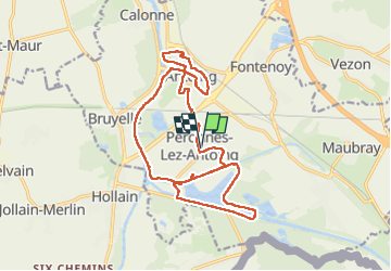
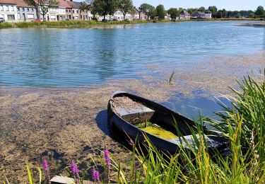
Tour Wandern von 18,4 km verfügbar auf Wallonien, Hennegau, Antoing. Diese Tour wird von jeangulu vorgeschlagen.
Beschreibung
Point de départ : Salle Paroissiale - Rue du Centre , 56 - 7640 Péronnes - LEZ- Antoing.
Organisateur : HT 069 - LES MARCHEURS DU HAUT- ESCAUT
Ort
Land:
Belgium
Region :
Wallonien
Abteilung/Provinz :
Hennegau
Kommune :
Antoing
Standort:
Péronnes
Gehen Sie:(Dec)
Gehen Sie:(UTM)
532196 ; 5600041 (31U) N.
Kommentare
Touren in der Umgebung
![Tour Wandern Antoing - grand large- penonnes lez antoing - Photo](https://media.geolcdn.com/t/375/260/ext.jpg?maxdim=2&url=https%3A%2F%2Fservices.sitytrail.com%2FGeolivesWS%2FDownloadMedia.ashx%3FTrailID%3D653025%26Media%3Dfix__20161029165326.jpg)
![Wandern Wandern](https://static1.geolcdn.com/sitytour/trail-icons/101.png)
grand large- penonnes lez antoing
Wandern
Einfach
(3)
Antoing,
Wallonien,
Hennegau,
Belgium
![](/images/other/stat-length.png)
9,9 km | 10,7 km-effort
2h 12min
![](https://static1.geolcdn.com/siteimages/upload/files/16400158638029165_repeat_loop_refresh_sync_direction_icon.png)
Ja
![Tour Wandern Brunehaut - Circuit de la coupure de Bléharies - Photo](https://media.geolcdn.com/t/375/260/ext.jpg?maxdim=2&url=https%3A%2F%2Fmedia.geolcdn.com%2Ff%2Fc388fd6c-a6df-4e66-add0-50e55c75a52e.jpg)
![Wandern Wandern](https://static1.geolcdn.com/sitytour/trail-icons/101.png)
Circuit de la coupure de Bléharies
Wandern
Einfach
Brunehaut,
Wallonien,
Hennegau,
Belgium
![](/images/other/stat-length.png)
3,7 km | 4 km-effort
54min
![](https://static1.geolcdn.com/siteimages/upload/files/16400158638029165_repeat_loop_refresh_sync_direction_icon.png)
Ja
![Tour Wandern Antoing - Balade au coeur de Péronnes - Photo](https://media.geolcdn.com/t/375/260/ext.jpg?maxdim=2&url=https%3A%2F%2Fmedia.geolcdn.com%2Ff%2Fd7561409-c7bf-436c-aa67-e1ca13223359.jpg)
![Wandern Wandern](https://static1.geolcdn.com/sitytour/trail-icons/101.png)
Balade au coeur de Péronnes
Wandern
Einfach
(1)
Antoing,
Wallonien,
Hennegau,
Belgium
![](/images/other/stat-length.png)
4,5 km | 4,9 km-effort
1h 6min
![](https://static1.geolcdn.com/siteimages/upload/files/16400158638029165_repeat_loop_refresh_sync_direction_icon.png)
Ja
![Tour Zu Fuß Tournai - A la découverte des métiers d'antan - Photo](https://media.geolcdn.com/t/375/260/ext.jpg?maxdim=2&url=https%3A%2F%2Fpivotmedia.tourismewallonie.be%2FANX-02-04JL-021I%2FANX-02-04JL-021I.jpg)
![Zu Fuß Zu Fuß](https://static1.geolcdn.com/sitytour/trail-icons/100.png)
A la découverte des métiers d'antan
Zu Fuß
Einfach
(1)
Tournai,
Wallonien,
Hennegau,
Belgium
![](/images/other/stat-length.png)
6,8 km | 7,8 km-effort
1h 46min
![](https://static1.geolcdn.com/siteimages/upload/files/16400158638029165_repeat_loop_refresh_sync_direction_icon.png)
Ja
![Tour Zu Fuß Brunehaut - Circuit des pépinières de Lesdain - Photo](https://media.geolcdn.com/t/375/260/ext.jpg?maxdim=2&url=https%3A%2F%2Fpivotmedia.tourismewallonie.be%2FANX-02-04JM-0024%2FANX-02-04JM-0024.jpg)
![Zu Fuß Zu Fuß](https://static1.geolcdn.com/sitytour/trail-icons/100.png)
Circuit des pépinières de Lesdain
Zu Fuß
Einfach
(1)
Brunehaut,
Wallonien,
Hennegau,
Belgium
![](/images/other/stat-length.png)
6,2 km | 6,6 km-effort
1h 29min
![](https://static1.geolcdn.com/siteimages/upload/files/16400158638029165_repeat_loop_refresh_sync_direction_icon.png)
Ja
![Tour Zu Fuß Antoing - Circuit du Pays Blanc - Photo](https://media.geolcdn.com/t/375/260/ext.jpg?maxdim=2&url=https%3A%2F%2Fpivotmedia.tourismewallonie.be%2FANX-02-04JV-0001%2FANX-02-04JV-0001.jpg)
![Zu Fuß Zu Fuß](https://static1.geolcdn.com/sitytour/trail-icons/100.png)
Circuit du Pays Blanc
Zu Fuß
Einfach
Antoing,
Wallonien,
Hennegau,
Belgium
![](/images/other/stat-length.png)
12,3 km | 14,3 km-effort
3h 14min
![](https://static1.geolcdn.com/siteimages/upload/files/16400158638029165_repeat_loop_refresh_sync_direction_icon.png)
Ja
![Tour Zu Fuß Brunehaut - Circuit de la coupure de Bléharies - 3,5km - Photo](https://media.geolcdn.com/t/375/260/ext.jpg?maxdim=2&url=https%3A%2F%2Fpivotmedia.tourismewallonie.be%2FANX-02-04JP-002T%2FANX-02-04JP-002T.jpg)
![Zu Fuß Zu Fuß](https://static1.geolcdn.com/sitytour/trail-icons/100.png)
Circuit de la coupure de Bléharies - 3,5km
Zu Fuß
Einfach
Brunehaut,
Wallonien,
Hennegau,
Belgium
![](/images/other/stat-length.png)
3,7 km | 3,9 km-effort
53min
![](https://static1.geolcdn.com/siteimages/upload/files/16400158638029165_repeat_loop_refresh_sync_direction_icon.png)
Ja
![Tour Rennrad Tournai - Brau vélo Ravel Antoing - Photo](https://media.geolcdn.com/t/375/260/ext.jpg?maxdim=2&url=https%3A%2F%2Fstatic1.geolcdn.com%2Fsiteimages%2Fupload%2Ffiles%2F1524743154velo.jpg)
![Rennrad Rennrad](https://static1.geolcdn.com/sitytour/trail-icons/201.png)
Brau vélo Ravel Antoing
Rennrad
Sehr leicht
(1)
Tournai,
Wallonien,
Hennegau,
Belgium
![](/images/other/stat-length.png)
28 km | 31 km-effort
2h 22min
![](https://static1.geolcdn.com/siteimages/upload/files/16400158638029165_repeat_loop_refresh_sync_direction_icon.png)
Ja
![Tour Wandern Brunehaut - RB - H - 15 Lesdain - Photo](https://media.geolcdn.com/t/375/260/ext.jpg?maxdim=2&url=https%3A%2F%2Fservices.sitytrail.com%2FGeolivesWS%2FDownloadMedia.ashx%3FTrailID%3D617918%26Media%3Dfix__20160820190940.jpg)
![Wandern Wandern](https://static1.geolcdn.com/sitytour/trail-icons/101.png)
RB - H - 15 Lesdain
Wandern
Sehr leicht
Brunehaut,
Wallonien,
Hennegau,
Belgium
![](/images/other/stat-length.png)
17,7 km | 18,9 km-effort
3h 55min
![](https://static1.geolcdn.com/siteimages/upload/files/16400158638029165_repeat_loop_refresh_sync_direction_icon.png)
Ja