![](/images/other/stat-length.png)
![Tour Wandern Saint-Christophe - 190323 Boucle voie Sarde - Photo](https://media.geolcdn.com/t/1900/400/ext.pjpeg?maxdim=2&url=https%3A%2F%2Fmedia.geolcdn.com%2Ff%2F73c09b18-e12a-4062-a718-c9e9afd93b05.jpg)
190323 Boucle voie Sarde
mzonzon05
Benutzer
![Länge](/images/other/stat-length.png)
Länge
9,7 km
![Maximale Höhe](https://static1.geolcdn.com/siteimages/upload/files/1508320355ic_sort_altitude_max_24dp.png)
Maximale Höhe
599 m
![Positive Höhendifferenz](https://static1.geolcdn.com/siteimages/upload/files/1508320355ic_sort_den_pos_24dp.png)
Positive Höhendifferenz
437 m
![Km-Effort](/images/other/stat-length.png)
Km-Effort
15,6 km
![Min. Höhe](https://static1.geolcdn.com/siteimages/upload/files/1508320355ic_sort_altitude_min_24dp.png)
Min. Höhe
418 m
![Negative Höhendifferenz](https://static1.geolcdn.com/siteimages/upload/files/1508320355ic_sort_den_neg_24dp.png)
Negative Höhendifferenz
434 m
![Boucle](https://static1.geolcdn.com/siteimages/upload/files/16400158638029165_repeat_loop_refresh_sync_direction_icon.png)
Boucle
Ja
Erstellungsdatum :
2023-03-19 11:11:56.932
Letzte Änderung :
2023-03-19 15:28:01.59
![Wandern](https://static1.geolcdn.com/sitytour/trail-icons/101.png)
3h50
Schwierigkeit : Schwierig
![Scannen Sie diesen QR-Code, um die Tour in der SityTrail-Anwendung zu öffnen](https://capi.geolives.com/qq0zvz2zws4bq2lad0pu/sitytour/trails/3590411/qr.png?size=200)
Kostenlosegpshiking-Anwendung
Über SityTrail
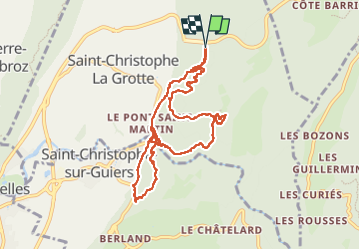
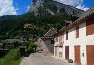
Tour Wandern von 9,7 km verfügbar auf Auvergne-Rhone-Alpen, Savoyen, Saint-Christophe. Diese Tour wird von mzonzon05 vorgeschlagen.
Beschreibung
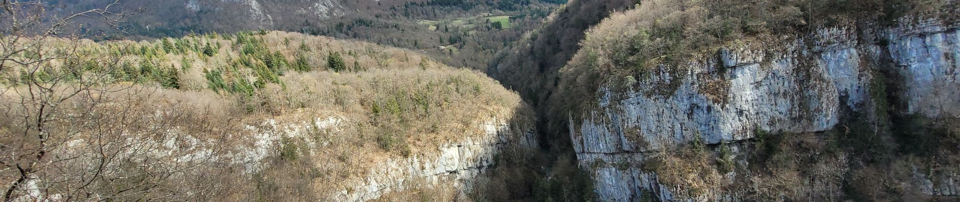
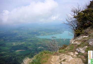
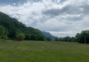
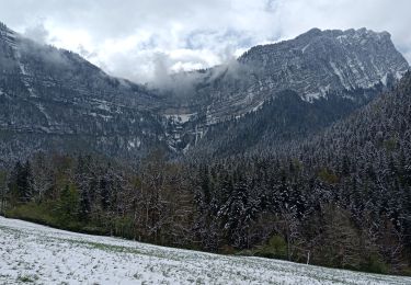
Jolie boucle au frais le long du Guirrs Vif parfois, alternant bon sentiers forestiers et sentiers de chèvres 🐐.
Certainement un bon terrain de jeu pour ceux qui aiment le trail
Ort
Land:
France
Region :
Auvergne-Rhone-Alpen
Abteilung/Provinz :
Savoyen
Kommune :
Saint-Christophe
Standort:
Unknown
Gehen Sie:(Dec)
Gehen Sie:(UTM)
718290 ; 5037058 (31T) N.
Kommentare
Touren in der Umgebung
![Tour Schneeschuhwandern Saint-Christophe-sur-Guiers - Le Belvédère d'Arpison - Photo](https://media.geolcdn.com/t/375/260/ext.jpg?maxdim=2&url=https%3A%2F%2Fservices.sitytrail.com%2FGeolivesWS%2FDownloadMedia.ashx%3FTrailID%3D699429%26Media%3Dfix__20170216145739.jpg)
![Schneeschuhwandern Schneeschuhwandern](https://static1.geolcdn.com/sitytour/trail-icons/504.png)
Le Belvédère d'Arpison
Schneeschuhwandern
Medium
(1)
Saint-Christophe-sur-Guiers,
Auvergne-Rhone-Alpen,
Isère,
France
![](/images/other/stat-length.png)
11,1 km | 17,4 km-effort
4h 43min
![](https://static1.geolcdn.com/siteimages/upload/files/16400158638029165_repeat_loop_refresh_sync_direction_icon.png)
Ja
![Tour Wandern Attignat-Oncin - Le Mont Grelle 1425m, depuis Attignat - Oncin - Photo](https://media.geolcdn.com/t/375/260/ext.jpg?maxdim=2&url=https%3A%2F%2Fservices.sitytrail.com%2FGeolivesWS%2FDownloadMedia.ashx%3FTrailID%3D102436%26Media%3D3086_1.jpg)
![Wandern Wandern](https://static1.geolcdn.com/sitytour/trail-icons/101.png)
Le Mont Grelle 1425m, depuis Attignat - Oncin
Wandern
Medium
(3)
Attignat-Oncin,
Auvergne-Rhone-Alpen,
Savoyen,
France
![](/images/other/stat-length.png)
9,6 km | 17,6 km-effort
4h 30min
![](https://static1.geolcdn.com/siteimages/upload/files/16400158638029165_repeat_loop_refresh_sync_direction_icon.png)
Ja
![Tour Wandern Saint-Pierre-d'Entremont - Roche Veyrand par les Clapiers, 1429m - Photo](https://media.geolcdn.com/t/375/260/ext.jpg?maxdim=2&url=https%3A%2F%2Fservices.sitytrail.com%2FGeolivesWS%2FDownloadMedia.ashx%3FTrailID%3D101734%26Media%3D1981_1.jpg)
![Wandern Wandern](https://static1.geolcdn.com/sitytour/trail-icons/101.png)
Roche Veyrand par les Clapiers, 1429m
Wandern
Schwierig
(1)
Saint-Pierre-d'Entremont,
Auvergne-Rhone-Alpen,
Savoyen,
France
![](/images/other/stat-length.png)
4,8 km | 14,3 km-effort
4h 10min
![](https://static1.geolcdn.com/siteimages/upload/files/16400158638029165_repeat_loop_refresh_sync_direction_icon.png)
Ja
![Tour sport Saint-Christophe - La grotte - Photo](https://media.geolcdn.com/t/375/260/ext.jpg?maxdim=2&url=https%3A%2F%2Fmedia.geolcdn.com%2Ff%2F7cc75393-f761-46d1-becb-3cd7fb47c0ce.jpg)
La grotte
sport
Sehr leicht
Saint-Christophe,
Auvergne-Rhone-Alpen,
Savoyen,
France
![](/images/other/stat-length.png)
8,9 km | 14,1 km-effort
Unbekannt
![](https://static1.geolcdn.com/siteimages/upload/files/16400158638029165_repeat_loop_refresh_sync_direction_icon.png)
Nein
![Tour Wandern Saint-Pierre-d'Entremont - Cirque de Saint Même depuis Saint Pierre d'Entremont - Photo](https://media.geolcdn.com/t/375/260/ext.jpg?maxdim=2&url=https%3A%2F%2Fmedia.geolcdn.com%2Ff%2Fd8ba31e0-3557-41dc-9d69-64812f8f36da.jpg)
![Wandern Wandern](https://static1.geolcdn.com/sitytour/trail-icons/101.png)
Cirque de Saint Même depuis Saint Pierre d'Entremont
Wandern
Medium
Saint-Pierre-d'Entremont,
Auvergne-Rhone-Alpen,
Isère,
France
![](/images/other/stat-length.png)
10,9 km | 17,2 km-effort
4h 22min
![](https://static1.geolcdn.com/siteimages/upload/files/16400158638029165_repeat_loop_refresh_sync_direction_icon.png)
Ja
![Tour Wandern Saint-Christophe - la voie SARDE / tunnel des l'Echelles /st Christophe sur Guiers - Photo](https://media.geolcdn.com/t/375/260/ext.jpg?maxdim=2&url=https%3A%2F%2Fmedia.geolcdn.com%2Ff%2Fbd7592a8-f593-4f63-a47d-b73ccb71a038.JPG)
![Wandern Wandern](https://static1.geolcdn.com/sitytour/trail-icons/101.png)
la voie SARDE / tunnel des l'Echelles /st Christophe sur Guiers
Wandern
Sehr schwierig
Saint-Christophe,
Auvergne-Rhone-Alpen,
Savoyen,
France
![](/images/other/stat-length.png)
15,1 km | 23 km-effort
5h 12min
![](https://static1.geolcdn.com/siteimages/upload/files/16400158638029165_repeat_loop_refresh_sync_direction_icon.png)
Ja
![Tour Wandern Saint-Christophe - Grottes des Echelles - Photo](https://media.geolcdn.com/t/375/260/ext.jpg?maxdim=2&url=https%3A%2F%2Fmedia.geolcdn.com%2Ff%2Ff2889bde-9656-4c7e-b17e-05cfcb9808a9.jpg)
![Wandern Wandern](https://static1.geolcdn.com/sitytour/trail-icons/101.png)
Grottes des Echelles
Wandern
Medium
Saint-Christophe,
Auvergne-Rhone-Alpen,
Savoyen,
France
![](/images/other/stat-length.png)
7,4 km | 12,1 km-effort
3h 16min
![](https://static1.geolcdn.com/siteimages/upload/files/16400158638029165_repeat_loop_refresh_sync_direction_icon.png)
Ja
![Tour Wandern La Bauche - Ballade vers la Bauche - Photo](https://media.geolcdn.com/t/375/260/ext.jpg?maxdim=2&url=https%3A%2F%2Fmedia.geolcdn.com%2Ff%2Fbeac6041-f762-4265-baf1-b8a107f85ed8.jpg)
![Wandern Wandern](https://static1.geolcdn.com/sitytour/trail-icons/101.png)
Ballade vers la Bauche
Wandern
Einfach
La Bauche,
Auvergne-Rhone-Alpen,
Savoyen,
France
![](/images/other/stat-length.png)
11,7 km | 23 km-effort
6h 19min
![](https://static1.geolcdn.com/siteimages/upload/files/16400158638029165_repeat_loop_refresh_sync_direction_icon.png)
Ja
![Tour Wandern Saint-Pierre-d'Entremont - Saint Pierre d'Entremont (Isère) Cirque de Saint Même - Photo](https://media.geolcdn.com/t/375/260/ext.jpg?maxdim=2&url=https%3A%2F%2Fmedia.geolcdn.com%2Ff%2F7955fac0-9fac-4bcb-a044-347637dc23d5.jpg)
![Wandern Wandern](https://static1.geolcdn.com/sitytour/trail-icons/101.png)
Saint Pierre d'Entremont (Isère) Cirque de Saint Même
Wandern
Medium
Saint-Pierre-d'Entremont,
Auvergne-Rhone-Alpen,
Isère,
France
![](/images/other/stat-length.png)
11,4 km | 18,7 km-effort
2h 44min
![](https://static1.geolcdn.com/siteimages/upload/files/16400158638029165_repeat_loop_refresh_sync_direction_icon.png)
Ja