![](/images/other/stat-length.png)
![Tour Wandern Saint-Vallier-de-Thiey - Panadieu-ancienne Rte Napoléon de St Vallier à Escragnolles-18-04-23 - Photo](https://media.geolcdn.com/t/1900/400/ext.pjpeg?maxdim=2&url=https%3A%2F%2Fmedia.geolcdn.com%2Ff%2F2e9aac37-8793-4eae-b02a-560b2674cf9a.jpg)
Panadieu-ancienne Rte Napoléon de St Vallier à Escragnolles-18-04-23
Christiancordin
Benutzer
![Länge](/images/other/stat-length.png)
Länge
20 km
![Maximale Höhe](https://static1.geolcdn.com/siteimages/upload/files/1508320355ic_sort_altitude_max_24dp.png)
Maximale Höhe
1153 m
![Positive Höhendifferenz](https://static1.geolcdn.com/siteimages/upload/files/1508320355ic_sort_den_pos_24dp.png)
Positive Höhendifferenz
886 m
![Km-Effort](/images/other/stat-length.png)
Km-Effort
32 km
![Min. Höhe](https://static1.geolcdn.com/siteimages/upload/files/1508320355ic_sort_altitude_min_24dp.png)
Min. Höhe
492 m
![Negative Höhendifferenz](https://static1.geolcdn.com/siteimages/upload/files/1508320355ic_sort_den_neg_24dp.png)
Negative Höhendifferenz
887 m
![Boucle](https://static1.geolcdn.com/siteimages/upload/files/16400158638029165_repeat_loop_refresh_sync_direction_icon.png)
Boucle
Ja
Erstellungsdatum :
2023-04-18 07:12:57.816
Letzte Änderung :
2023-04-22 17:22:28.74
![Wandern](https://static1.geolcdn.com/sitytour/trail-icons/101.png)
7h00
Schwierigkeit : Schwierig
![Scannen Sie diesen QR-Code, um die Tour in der SityTrail-Anwendung zu öffnen](https://capi.geolives.com/qq0zvz2zws4bq2lad0pu/sitytour/trails/3626456/qr.png?size=200)
Kostenlosegpshiking-Anwendung
Über SityTrail
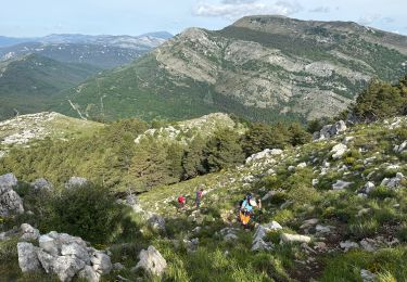
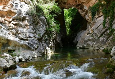
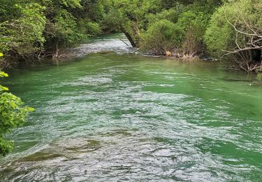
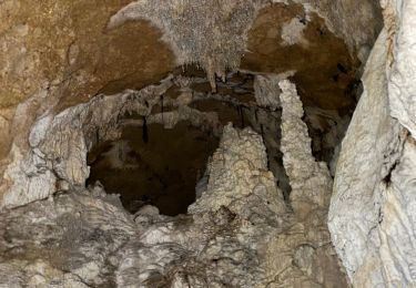
Tour Wandern von 20 km verfügbar auf Provence-Alpes-Côte d'Azur, Seealpen, Saint-Vallier-de-Thiey. Diese Tour wird von Christiancordin vorgeschlagen.
Beschreibung
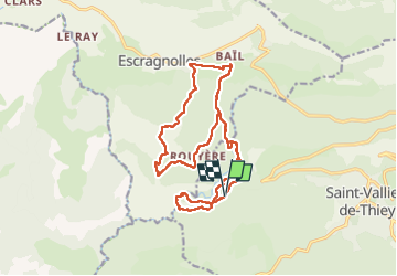
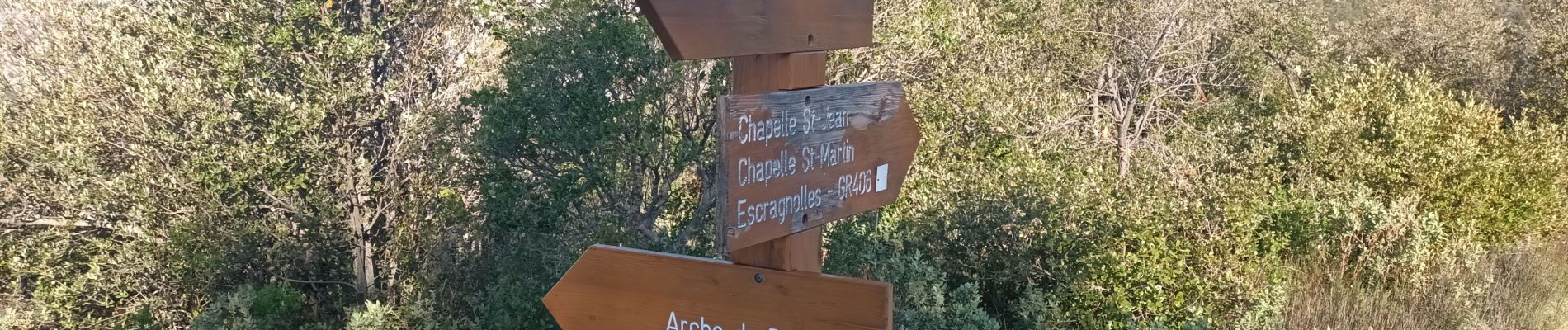
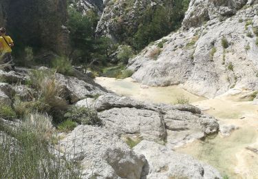
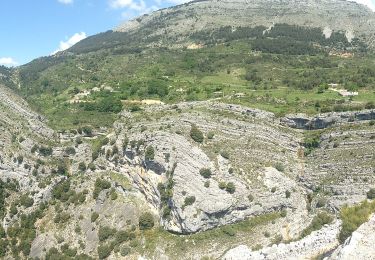
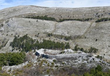
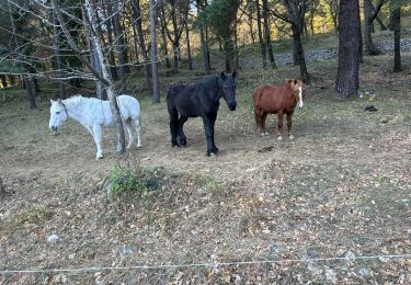
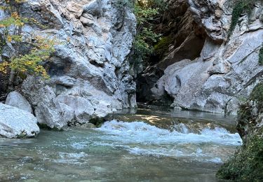
Pk de la citerne-le Ponadieu-la Siagne-grotte des 2 Goules-GR 510-chapelle St Jean- le vieux pont-Ancienne rte Napoléon-chapelle St Martin-Escragnolles-point de vue-Rouyère hameau en ruine.
Ort
Land:
France
Region :
Provence-Alpes-Côte d'Azur
Abteilung/Provinz :
Seealpen
Kommune :
Saint-Vallier-de-Thiey
Standort:
Unknown
Gehen Sie:(Dec)
Gehen Sie:(UTM)
323036 ; 4840870 (32T) N.
Kommentare
Touren in der Umgebung
![Tour Wandern Escragnolles - Casade du Ray (Clars) depuis les Gallants - Photo](https://media.geolcdn.com/t/375/260/ext.jpg?maxdim=2&url=https%3A%2F%2Fmedia.geolcdn.com%2Ff%2Fa42f38d6-7773-4eff-b635-6c5634fe1592.jpg)
![Wandern Wandern](https://static1.geolcdn.com/sitytour/trail-icons/101.png)
Casade du Ray (Clars) depuis les Gallants
Wandern
Sehr leicht
(1)
Escragnolles,
Provence-Alpes-Côte d'Azur,
Seealpen,
France
![](/images/other/stat-length.png)
938 m | 1,3 km-effort
20min
![](https://static1.geolcdn.com/siteimages/upload/files/16400158638029165_repeat_loop_refresh_sync_direction_icon.png)
Nein
![Tour Zu Fuß Escragnolles - Plateau de Briasq - Photo](https://media.geolcdn.com/t/375/260/ext.jpg?maxdim=2&url=https%3A%2F%2Fmedia.geolcdn.com%2Ff%2F3318d519-9f3b-4858-a9ae-b470b623f859.jpeg)
![Zu Fuß Zu Fuß](https://static1.geolcdn.com/sitytour/trail-icons/100.png)
Plateau de Briasq
Zu Fuß
Medium
Escragnolles,
Provence-Alpes-Côte d'Azur,
Seealpen,
France
![](/images/other/stat-length.png)
14,1 km | 22 km-effort
4h 56min
![](https://static1.geolcdn.com/siteimages/upload/files/16400158638029165_repeat_loop_refresh_sync_direction_icon.png)
Ja
![Tour Wandern Saint-Vallier-de-Thiey - St Vallier : Colle du maçon doublier - Photo](https://media.geolcdn.com/t/375/260/ext.jpg?maxdim=2&url=https%3A%2F%2Fmedia.geolcdn.com%2Ff%2F4e394125-44db-4de9-b615-b5e106949b4d.jpg)
![Wandern Wandern](https://static1.geolcdn.com/sitytour/trail-icons/101.png)
St Vallier : Colle du maçon doublier
Wandern
Schwierig
Saint-Vallier-de-Thiey,
Provence-Alpes-Côte d'Azur,
Seealpen,
France
![](/images/other/stat-length.png)
18,2 km | 29 km-effort
6h 35min
![](https://static1.geolcdn.com/siteimages/upload/files/16400158638029165_repeat_loop_refresh_sync_direction_icon.png)
Ja
![Tour Wandern Saint-Vallier-de-Thiey - St Vallier de Thiey - Col de la Lèque - Chapelle St Jean - Arche Ponadieu - Photo](https://media.geolcdn.com/t/375/260/ext.jpg?maxdim=2&url=https%3A%2F%2Fmedia.geolcdn.com%2Ff%2F05918623-5269-4fde-a6db-7248b99e79ca.JPG)
![Wandern Wandern](https://static1.geolcdn.com/sitytour/trail-icons/101.png)
St Vallier de Thiey - Col de la Lèque - Chapelle St Jean - Arche Ponadieu
Wandern
Medium
Saint-Vallier-de-Thiey,
Provence-Alpes-Côte d'Azur,
Seealpen,
France
![](/images/other/stat-length.png)
14,1 km | 21 km-effort
4h 44min
![](https://static1.geolcdn.com/siteimages/upload/files/16400158638029165_repeat_loop_refresh_sync_direction_icon.png)
Ja
![Tour Wandern Saint-Cézaire-sur-Siagne - Le canal et la rivière de la Siagne - Photo](https://media.geolcdn.com/t/375/260/ext.jpg?maxdim=2&url=https%3A%2F%2Fmedia.geolcdn.com%2Ff%2F8dec3c8f-da07-4204-a170-c1946b688755.jpg)
![Wandern Wandern](https://static1.geolcdn.com/sitytour/trail-icons/101.png)
Le canal et la rivière de la Siagne
Wandern
Medium
Saint-Cézaire-sur-Siagne,
Provence-Alpes-Côte d'Azur,
Seealpen,
France
![](/images/other/stat-length.png)
8,4 km | 13,9 km-effort
3h 8min
![](https://static1.geolcdn.com/siteimages/upload/files/16400158638029165_repeat_loop_refresh_sync_direction_icon.png)
Ja
![Tour Wandern Saint-Vallier-de-Thiey - St Vallier : Pare2 - Photo](https://media.geolcdn.com/t/375/260/ext.jpg?maxdim=2&url=https%3A%2F%2Fmedia.geolcdn.com%2Ff%2F0e23e1f7-5365-422d-9e17-aca855b1fa8e.jpeg)
![Wandern Wandern](https://static1.geolcdn.com/sitytour/trail-icons/101.png)
St Vallier : Pare2
Wandern
Schwierig
Saint-Vallier-de-Thiey,
Provence-Alpes-Côte d'Azur,
Seealpen,
France
![](/images/other/stat-length.png)
17,7 km | 29 km-effort
6h 35min
![](https://static1.geolcdn.com/siteimages/upload/files/16400158638029165_repeat_loop_refresh_sync_direction_icon.png)
Ja
![Tour Wandern Saint-Vallier-de-Thiey - St Vallier de Thiey - Col du Ferrier - Castellaras de la Malle - Col du Pilon - Pierre Druidique - Photo](https://media.geolcdn.com/t/375/260/ext.jpg?maxdim=2&url=https%3A%2F%2Fmedia.geolcdn.com%2Ff%2F0ca7f168-1d3d-4587-8f54-5963a04b7048.JPG)
![Wandern Wandern](https://static1.geolcdn.com/sitytour/trail-icons/101.png)
St Vallier de Thiey - Col du Ferrier - Castellaras de la Malle - Col du Pilon...
Wandern
Medium
Saint-Vallier-de-Thiey,
Provence-Alpes-Côte d'Azur,
Seealpen,
France
![](/images/other/stat-length.png)
18,9 km | 28 km-effort
6h 18min
![](https://static1.geolcdn.com/siteimages/upload/files/16400158638029165_repeat_loop_refresh_sync_direction_icon.png)
Ja
![Tour Wandern Saint-Vallier-de-Thiey - Montagne de Thiey 2 - Photo](https://media.geolcdn.com/t/375/260/ext.jpg?maxdim=2&url=https%3A%2F%2Fmedia.geolcdn.com%2Ff%2Fe67f18b8-11b7-47ac-9962-78c54d88cde0.jpg)
![Wandern Wandern](https://static1.geolcdn.com/sitytour/trail-icons/101.png)
Montagne de Thiey 2
Wandern
Medium
Saint-Vallier-de-Thiey,
Provence-Alpes-Côte d'Azur,
Seealpen,
France
![](/images/other/stat-length.png)
19,3 km | 31 km-effort
6h 57min
![](https://static1.geolcdn.com/siteimages/upload/files/16400158638029165_repeat_loop_refresh_sync_direction_icon.png)
Ja
![Tour Wandern Saint-Vallier-de-Thiey - Arche de Ponadieu Source de la Pare Baou Mourine Vieux Pont - Photo](https://media.geolcdn.com/t/375/260/ext.jpg?maxdim=2&url=https%3A%2F%2Fmedia.geolcdn.com%2Ff%2F7bf7c645-d759-4e3b-9f63-302e7218f005.jpg)
![Wandern Wandern](https://static1.geolcdn.com/sitytour/trail-icons/101.png)
Arche de Ponadieu Source de la Pare Baou Mourine Vieux Pont
Wandern
Sehr schwierig
Saint-Vallier-de-Thiey,
Provence-Alpes-Côte d'Azur,
Seealpen,
France
![](/images/other/stat-length.png)
19,2 km | 32 km-effort
7h 20min
![](https://static1.geolcdn.com/siteimages/upload/files/16400158638029165_repeat_loop_refresh_sync_direction_icon.png)
Ja