


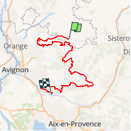

14,4 km | 26 km-effort

Randonnées de Vélo Loisir Provence GUIDE+


Kostenlosegpshiking-Anwendung
 SityTrail
IGN / Geografische Institute
SityTrail World
Die Welt öffnet sich für Sie
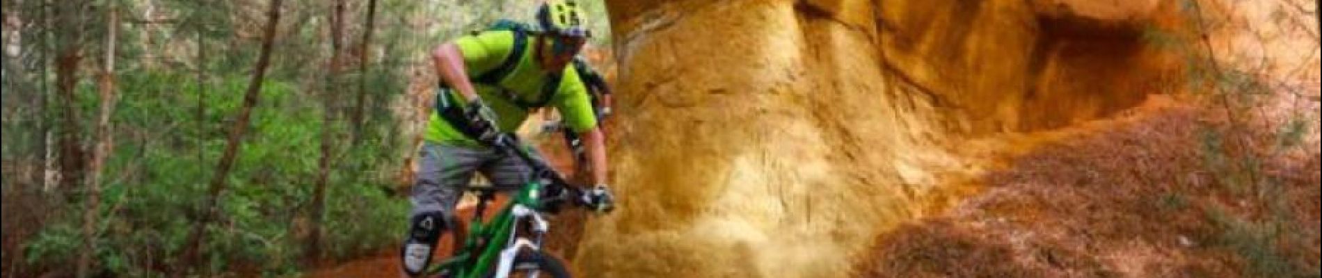
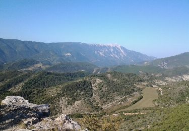
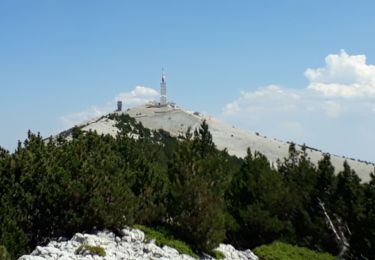
Tour Mountainbike von 331 km verfügbar auf Auvergne-Rhone-Alpen, Drôme, Reilhanette. Diese Tour wird von Vélo Loisir Provence vorgeschlagen.
What better than by mountain bike to explore the Vaucluse region? “La Grande Traversée VTT de Vaucluse” is an itinerary composed of 18 sections (9 stages) of 16 to 30km/ 10 to 19 miles, each of which generally coincides with a stopping point such as a hostelry or village. However these sections do not take into account the difference in physical capability between a regular cyclist and a strong mountain biker and may be considered suitable only for certain cyclists. It is up to the individual to decide in respect of his technical and physical level and in view of the availability of the respective accommodation. Numerous variations are possible and there are two proposed formulae leaving from Savoillans which finish at Mérindol. Via Le Luberon in 7 stages of 35 to 55 km/22 to 35 miles, 330km/206 miles in total, difference in altitude, D :9900m and D-:9500m. Via les Monts de Vaucluse in 6 stages from 35 to 55km/22 to 35 miles, 227km/173 miles in total, difference in altitude D :7700m and D-: 8100m Note that for long weekends it’s possible to take a variant route over 3 days: Manosque – Cavaillon or to extend “La Grande Traversée de Vaucluse” from Manosque onto “La Grande Traversée VTT Alpes-Provence” via a signposted connection at Mont-Justin. More information about "La Grande Traversée de Vaucluse via Le Luberon" in mountain bike in the Luberon part : GTV VTT Section 4 Aurel - Saint-Saturnin-les-Apt : 53,9 km - D : 1 015 m - D- : 1 402 m The Plateau de Sault is a landscape make up of vast open plains, shaped by fields of grains, grasses (small spelt) and lavender. From Aurel, this fast-moving route, which offers little in the way of difficulty, will lead you to Sault and its racecourse, the highest in France (800 m), through woods and open spaces. It’s then an easy descent towards Monieux followed by one of the highlights of this long distance trail: the Gorges de la Nesque. A superb path climbs up towards the Vaucluse mountains where you’ll enjoy an unforgettable view of the Gorges,one of the world’s most stunning canyons Download GPX file GTV VTT Section 7 Aurel - Saint-Hubert This long but extremely beautiful stretch boasts fabulous single-track trails through exceptional scenery. The trail through this remote and little frequented part of the Vaucluse mountains will eventually lead you to the Luberon Natural Regional Park. You’ll pass through a place known as Savouillon, after which you'll start to notice ancient stone water tanks (aiguiers), an extraordinary and typical feature of this region. The trail then descends towards Saint Saturnin-les-Apt, through the abandoned hamlet of Travignon, following a succession of paths that alternate between challenging and fast. Download GPX file GTV VTT Section 8 Saint-Hubert - Saint-Saturnin-les-Apt GTV VTT Etape 7 St-Saturnin-les-Apt - Vitrolles-en-Luberon : 46 km - D : 890 m - D- : 590 m After a few kilometres of fast cycling through vineyards and cherry trees, along roads and paths, you’ll come to the ochre massif with its unusual landscapes and autumnal colours. The sandy and gritty single-tracks of the La Bruyère mountain range contrast with the hard, rocky landscapes of Provence. The ochre mountains then give way to stony trails leading to Rustrel. You’ll cycle along the Colorado Provençal, climbing a series of forest paths up to the Pierroux mountain ridge. This lovely single-track path, which boasts a wonderful panoramic view of the Lure mountain, will eventually lead you to the lovely village of Viens with its old city walls. Download GPX file GTV VTT Section 9 Saint-Saturnin-les-Apt - Viens The scenic route down to the valley, that you’ll hit shortly after Viens, will quickly awaken the mountain biker in you! The trail leads to the banks of the Calavon river, then through an old abandoned railway tunnel, to Céreste. After this little foray into the Alpes-de-Haute-Provence department, you’ll cycle along the ridges of Montjustin and its village, renovated by Giono and friends. You’ll then climb the vast undulating hills of the Grand Luberon mountain range before racing down the western slopes to Vitrolles-en-Luberon, nestled in the southern foothills. Download GPX file GTV VTT Section 10 Viens - Vitrolles-en-Luberon Liaison VTT balisée Grande Traversée VTT de Vaucluse - Grande Traversée VTT Alpes-Provence This marked mountain bike link goes between Manosque and Mont-Justin enabling a link up with La Grande Traversée de Vaucluse via Le Luberon and finishing at Mérindol instead of Manosque. The link is marked in both directions allowing mountain bikers from La Grande Traversée de Vaucluse via the Luberon to join up with La Grande Traversée Alpes-Provence in order to finish the mountain bike trail at Manosque instead of Mérindol. More information on Liaison VTT balisée Grande Traversée VTT de Vaucluse - Grande Traversée VTT Alpes-Provence More information on La Grande Traversée VTT Alpes-Provence Download GPX file of the Liaison VTT Grande Traversée VTT de Vaucluse - Grande Traversée VTT Alpes-Provence GTV VTT Etape 8 Vitrolles-en-Luberon - Lauris : 48 km - D : 1 090 m - D- : 1 330 m After an unforgiving start, setting off from Vitrolles-en-Luberon, you’ll follow a lovely trail along the wide ridges and pannonic steppes of the Grand Luberon, from where you’ll enjoy panoramic sea views to the south and views of Mont Ventoux to the north. The fittest among you may wish to follow the GR (Long distance footpath) that runs parallel to the bike trail. And if you’ve still got sufficient strength, you can take a short round trip up to the Mourre Nègre (1,125 m), the top of the Grand Luberon, before heading down the north-facing slope, through the young oak forest. The fabulous single-track path is quite narrow and stony in places, so you need to take care. A pretty trail, overlooking Marauvière, will lead you first to Auribeau, and then the vast Plateau de Claparèdes with its lavender fields and dry stone huts. Finally, you’ll reach, Sivergues, a village “at the end of the world,” as described by Henri Bosco. Download GPX file GTV VTT Section 11 Vitrolles-en-Luberon - Siguergues After Sivergues, you’ll pass through the the lush, steep-sided Aiguebrun Valley, following a stony path which, although bumpy at first, then becomes more forgiving. You’ll ride past magnificent cliffs, popular with rock climbers, and the foot of Buoux Fort. It’s then an arduous climb back up to the plateau to reach Bonnieux with its maze of narrow lanes and alleyways. Here, you’ll change mountain ranges, following a succession of rocky paths and trails up the slopes of the Petit Luberon. It’s a picture postcard route, punctuated by beautiful houses and splendid properties. Finally, you’ll enjoy a lovely single-file descent, over wild and challenging terrain, down to Lauris. Download GPX file GTV VTT Section 12 Siguergues - Lauris GTV VTT Etape 9 Lauris - Mérindol : 56 km - D : 1 040 m - D- : 1 120 m The trail starts with an easy ride, along a wide path, up the southern face of the Petit Luberon. However, the last 100 metres, before you reach Le Portalas (690m) are far from easy, over uneven and challenging terrain. At the top, you can enjoy a spectacular view of the Durance Valley, the Crau de Camargue and the Alpilles. You’ll then cut through the Cedar Forest, with its majestic, one-hundred-year-old trees, a landscape typical of this section of the Provençal trail. After that, you’ll sweep down to the bottom of an unspoiled valley, continuing to the foot of the northern slopes of the Grand Luberon. Here, the vegetation creates a landscape of startling contrasts. Next, you’ll follow a succession of paths and trails, of varying levels of difficulties, into the foothills of the Petit Luberon, continuing until you reach Oppède-le-Vieux, a village steeped in history, and then Maubec. Download GPX file GTV VTT Section 13 Lauris - Maubec From Maubec, you’ll quickly reach the medieval villages of Robion, along delightful single track paths, then Les Taillades, cycling alongside the mythical Carpentras Canal. From here, you’ll follow some pretty, windy trails, up the western slope and then the southern side of the Petit Luberon, through a mosaic of spectacular hilltops and deep valleys. A little further up, you’ll reach a succession of limestone plateaux: Le Trou du Rat, Les Mayorques and Saint-Phalez. This scrubland, shaped by man since the Neolithic Period, is characterised by lush valleys and a remarkable variety of wildlife, with exceptional birds, particularly, birds of prey. A final climb and then it’s time for a last dramatic descent along a pretty path, down to the old village of Mérindol, symbol of the persecution of the Waldensians in the Luberon. Download GPX file GTV VTT Section 14 Maubec - Mérindol For more information on this mountaine bike itinerary, go on our partner website "La Provence à Vélo".


Wandern
Wandern
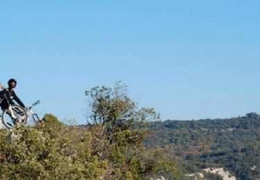
Mountainbike

Fahrrad
Wandern
Wandern

Wandern
Wandern
Wandern