Guillestre, Hautes-Alpes: Best trails, routes and walks

3 comments

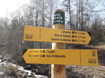
Guillestre: Discover the best trails: 60 hiking trails, 11 bike and mountain-bike routes and 1 equestrian circuits. All these trails, routes and outdoor activities are available in our SityTrail applications for smartphones and tablets.


The best trails (76)

Trail Walking Guillestre - Rue des Masques - Photo
Walking 5.119
Km

Walking

Very easy
(1)
Guillestre, Provence-Alpes-Côte d'Azur, Hautes-Alpes, France
5.1 km | 7.9 km-effort
1h 47min
208 m
205 m
Yes
Dervalmarc

• Sympathique et familiale.

Trail Walking Guillestre - guillestre, rif bel,col de la scie, crete de vars,la coulette et retour par riou bel - Photo
Walking 23.691
Km

Walking

Very difficult
Guillestre, Provence-Alpes-Côte d'Azur, Hautes-Alpes, France
24 km | 45 km-effort
6h 24min
1564 m
1567 m
Yes
tchoua

Trail Walking Guillestre - col garnies aller retour  - Photo
Walking 19.522
Km

Walking

Medium
Guillestre, Provence-Alpes-Côte d'Azur, Hautes-Alpes, France
19.5 km | 39 km-effort
4h 47min
1441 m
1433 m
Yes
tchoua

Trail Walking Guillestre - cugulet aller retour  - Photo
Walking 14.576
Km

Walking

Medium
Guillestre, Provence-Alpes-Côte d'Azur, Hautes-Alpes, France
14.6 km | 33 km-effort
4h 2min
1366 m
1371 m
Yes
tchoua

Trail Walking Guillestre - Roche Rousse et Rocher de l'aigle  à  Guillestre  - Photo
Walking 8.606
Km

Walking

Medium
Guillestre, Provence-Alpes-Côte d'Azur, Hautes-Alpes, France
8.6 km | 14 km-effort
2h 52min
403 m
406 m
Yes
Sorriaux

Trail Sled dogs Guillestre -  Charmousse. Ceillac  - Photo
Sled dogs 9.94
Km

Sled dogs

Difficult
Guillestre, Provence-Alpes-Côte d'Azur, Hautes-Alpes, France
9.9 km | 20 km-effort
3h 51min
812 m
621 m
No
jeff2

Trail Walking Guillestre - Le Villaret Barbein - Photo
Walking 10.216
Km

Walking

Medium
Guillestre, Provence-Alpes-Côte d'Azur, Hautes-Alpes, France
10.2 km | 16.2 km-effort
3h 7min
448 m
445 m
Yes
Sorriaux

Trail Walking Guillestre - Risoul le Villaret  Brunissard - Photo
Walking 9.29
Km

Walking

Easy
Guillestre, Provence-Alpes-Côte d'Azur, Hautes-Alpes, France
9.3 km | 14.9 km-effort
3h 0min
418 m
417 m
Yes
Sorriaux

Trail Walking Guillestre - Risoul: Le Villaret   Peyre Haute - Photo
Walking 8.575
Km

Walking

Easy
Guillestre, Provence-Alpes-Côte d'Azur, Hautes-Alpes, France
8.6 km | 12.8 km-effort
2h 48min
316 m
316 m
Yes
Sorriaux

Trail Walking Guillestre - Le Tour du Queyras (Bramousse - Ceillac) - Photo
Walking 10.073
Km

Walking

Medium
Guillestre, Provence-Alpes-Côte d'Azur, Hautes-Alpes, France
10.1 km | 22 km-effort
4h 0min
927 m
725 m
No
tracegps

Trail On foot Guillestre - Bramousse - Le Mélèze de Bramousse - Photo
On foot 9.196
Km
PRO

On foot

Easy
Guillestre, Provence-Alpes-Côte d'Azur, Hautes-Alpes, France
9.2 km | 17.4 km-effort
3h 57min
614 m
614 m
Yes
SityTrail - itinéraires balisés pédestres

• Trail created by Département des Hautes-Alpes.

Trail Mountain bike Guillestre - Boucle 7 le tour de Guillestre - Photo
Mountain bike 13.185
Km

Mountain bike

Easy
Guillestre, Provence-Alpes-Côte d'Azur, Hautes-Alpes, France
13.2 km | 19 km-effort
1h 44min
435 m
432 m
Yes
Leveil

Trail Walking Guillestre - la chalp - Photo
Walking 9.159
Km

Walking

Easy
Guillestre, Provence-Alpes-Côte d'Azur, Hautes-Alpes, France
9.2 km | 14 km-effort
3h 27min
365 m
362 m
Yes
cn2912

Trail Walking Guillestre - #1 Queyras 3j étape 4 Bramousse Ceillac - Photo
Walking 9.666
Km

Walking

Very difficult
Guillestre, Provence-Alpes-Côte d'Azur, Hautes-Alpes, France
9.7 km | 20 km-effort
4h 37min
866 m
606 m
No
Liobric

Trail Road bike Guillestre - Col de Vars - Photo
Road bike 18.802
Km

Road bike

Medium
Guillestre, Provence-Alpes-Côte d'Azur, Hautes-Alpes, France
18.8 km | 30 km-effort
2h 10min
1135 m
63 m
No
nadd73

Trail Walking Guillestre - boucle du Cugulet  - Photo
Walking 4.596
Km

Walking

Medium
Guillestre, Provence-Alpes-Côte d'Azur, Hautes-Alpes, France
4.6 km | 9.2 km-effort
1h 32min
223 m
725 m
No
PECHEUR

Trail On foot Guillestre - Alpes jour 7: Lieu de bivouac à Pont du moulin (bivouac) - Photo
On foot 15.492
Km

On foot

Medium
Guillestre, Provence-Alpes-Côte d'Azur, Hautes-Alpes, France
15.5 km | 35 km-effort
Unknown
1567 m
1075 m
No
MathieuBourgois

Trail Walking Guillestre - rue des masques  - Photo
Walking 3.184
Km

Walking

Easy
Guillestre, Provence-Alpes-Côte d'Azur, Hautes-Alpes, France
3.2 km | 5.1 km-effort
3h 20min
148 m
142 m
No
pierrot.duc

Trail Walking Guillestre - guillestre/haut gaudissart - Photo
Walking 4.766
Km

Walking

Very easy
Guillestre, Provence-Alpes-Côte d'Azur, Hautes-Alpes, France
4.8 km | 8.3 km-effort
2h 46min
336 m
65 m
No
egolibre

Trail Electric bike Guillestre - Bramousse Grangette pré fromage E bike - Photo
Electric bike 36.156
Km

Electric bike

Very easy
Guillestre, Provence-Alpes-Côte d'Azur, Hautes-Alpes, France
36 km | 62 km-effort
4h 28min
1944 m
1950 m
Yes
guilebike

20 trails displayed on 76

FREE GPS app for hiking

Logo SityTrail SityTrail

IGN / Geographical institutes

Download SityTrail from the App Store Download SityTrail from Google Play

Logo SityTrail SityTrail World

The world is yours!

Download SityTrail from the App Store Download SityTrail from Google Play Download SityTrail on Huawei AppGallery

Activities

Close
My subscriptions