Trail Walking Saint-Crépin-et-Carlucet - Saint-Crépin-et-Carlucet - Photo
 tracegps
tracegps

User

© OpenStreetMap contributors
Length
Length
15.3 km
Max alt
Max alt
272 m
Uphill gradient
Uphill gradient
382 m
Km-Effort
Km-Effort  
20 km
Min alt
Min alt
167 m
Downhill gradient
Downhill gradient
385 m
Boucle
Boucle
Yes
Creation date :
2014-12-10 00:00:00.0
Updated on :
2014-12-10 00:00:00.0

(3 Reviews)

Walking
Walking
3h00
Difficulty : Medium

Scan this QR Code to open this trail in the SityTrail application

FREE GPS app for hiking

Logo SityTrail SityTrail

IGN / Geographical institutes

Download SityTrail from the App Store Download SityTrail from Google Play

Logo SityTrail SityTrail World

The world is yours!

Download SityTrail from the App Store Download SityTrail from Google Play Download SityTrail on Huawei AppGallery

About

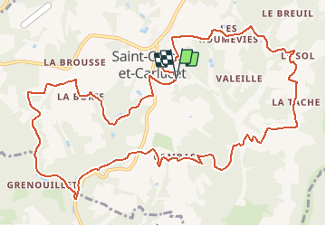
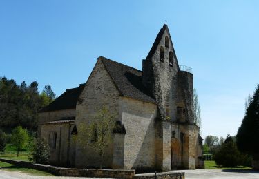
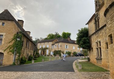
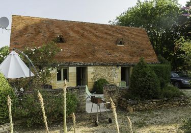
Trail Walking of 15.3 km to be discovered at New Aquitaine, Dordogne, Saint-Crépin-et-Carlucet. This trail is proposed by tracegps.

Description

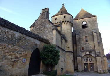
Beau circuit avec un patrimonie architectural abondant, une richesse de toitures en lauzes vraiment intéressante. A visiter l’exposition du manoir de Lacypierre. D’autres infos sur le site Rando.eu

Elevation profile

Photos

Positioning

Country:
France
Region :
New Aquitaine
Department/Province :
Dordogne
Municipality :
Saint-Crépin-et-Carlucet
Location:
Unknown
Start:(Dec)
Start:(UTM)
364167 ; 4979793 (31T) N.

Comments

Please log in to post a review or rate the element


b


Trails nearby

Trail On foot Saint-Geniès - Boucle des Etangs - Photo
On foot
PRO

On foot

Easy
Saint-Geniès, New Aquitaine, Dordogne, France
7.7 km | 9.7 km-effort
2h 12min
Yes
Trail Walking Saint-Crépin-et-Carlucet - Boucle de la Forêt de Saint-Crépin - Photo
Walking
houbart

Walking

Difficult
(1)
Saint-Crépin-et-Carlucet, New Aquitaine, Dordogne, France
11.4 km | 15.4 km-effort
3h 30min
Yes
Trail Electric bike Saint-Geniès - Boucle St Geniès Salignac - Photo
Electric bike
EricVIBERT

Electric bike

Medium
Saint-Geniès, New Aquitaine, Dordogne, France
27 km | 34 km-effort
3h 1min
Yes
Trail Walking Proissans - PROISSANS - Photo
Walking
RonanDAGORN

Walking

Easy
Proissans, New Aquitaine, Dordogne, France
12.1 km | 15.4 km-effort
3h 2min
Yes
Trail Walking Salignac-Eyvigues - Petite boucle du temps de vivre  - Photo
Walking
Gegetop

Walking

Easy
Salignac-Eyvigues, New Aquitaine, Dordogne, France
3.1 km | 4.5 km-effort
55min
Yes
Trail On foot Sainte-Nathalène - Sentier du Manoir d'Eyrignac - Photo
On foot
PRO

On foot

Easy
Sainte-Nathalène, New Aquitaine, Dordogne, France
5.1 km | 6.5 km-effort
1h 29min
No
Trail Walking Saint-Geniès - Saint Génies 19-09-2020 - Photo
Walking
robinier

Walking

Saint-Geniès, New Aquitaine, Dordogne, France
4.5 km | 5.7 km-effort
2h 1min
Yes
Trail Walking Saint-Geniès - boucle par moulins - Photo
Walking
taz5962

Walking

Easy
Saint-Geniès, New Aquitaine, Dordogne, France
11 km | 13.5 km-effort
2h 58min
Yes
Trail Walking Saint-Geniès - Saint-Geniès - Photo
Walking
tracegps

Walking

Medium
(3)
Saint-Geniès, New Aquitaine, Dordogne, France
9.9 km | 12.2 km-effort
2h 30min
Yes


Close
My subscriptions