Trail Walking Peyrusse - Le Puech - Peyrusse - Photo
 tracegps
tracegps

User

© OpenStreetMap contributors
Length
Length
12.9 km
Max alt
Max alt
1139 m
Uphill gradient
Uphill gradient
352 m
Km-Effort
Km-Effort  
17.6 km
Min alt
Min alt
933 m
Downhill gradient
Downhill gradient
351 m
Boucle
Boucle
Yes
Creation date :
2014-12-10 00:00:00.0
Updated on :
2014-12-10 00:00:00.0

(1 Reviews)

Walking
Walking
3h15
Difficulty : Difficult

Scan this QR Code to open this trail in the SityTrail application

FREE GPS app for hiking

Logo SityTrail SityTrail

IGN / Geographical institutes

Download SityTrail from the App Store Download SityTrail from Google Play

Logo SityTrail SityTrail World

The world is yours!

Download SityTrail from the App Store Download SityTrail from Google Play Download SityTrail on Huawei AppGallery

About

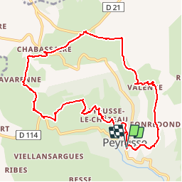
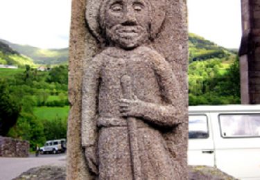
Trail Walking of 12.9 km to be discovered at Auvergne-Rhône-Alpes, Cantal, Peyrusse. This trail is proposed by tracegps.

Description

Très belle balade malgré un passage "humide" après Chabassaire lorsqu'il y a eu de fortes pluies les jours précédents. Dans ce cas, suivre la route à gauche après le repère 15, peu avant Peyrusse-Bas, pour éviter le gué. Balade numérisée sur le terrain par Jean louis Phillipart. Retrouvez cette randonnée dans le topo Guide Chamina Monts du Cézalier.

Elevation profile

Photos

Points of interest

Point of interest Peyrusse - 1 - Photo
tracegps
PEYRUSSE 
Point of interest Peyrusse - 10 - Photo
tracegps
PEYRUSSE 
Point of interest Peyrusse - 11 - Photo
tracegps
PEYRUSSE 
Point of interest Peyrusse - 12 - Photo
tracegps
PEYRUSSE 
Point of interest Peyrusse - 13 - Photo
tracegps
PEYRUSSE 
Point of interest Peyrusse - 14 - Photo
tracegps
PEYRUSSE 
Point of interest Peyrusse - 15 - Photo
tracegps
PEYRUSSE 
Point of interest Peyrusse - 2 - Photo
tracegps
PEYRUSSE 
Point of interest Peyrusse - 3 - Photo
tracegps
PEYRUSSE 
Point of interest Peyrusse - 4 - Photo
tracegps
PEYRUSSE 
Point of interest Peyrusse - 5 - Photo
tracegps
PEYRUSSE 
Point of interest Peyrusse - 6 - Photo
tracegps
PEYRUSSE 
Point of interest Peyrusse - 7 - Photo
tracegps
PEYRUSSE 
Point of interest Peyrusse - 8 - Photo
tracegps
PEYRUSSE 
Point of interest Peyrusse - 9 - Photo
tracegps
PEYRUSSE 
Point of interest Peyrusse - départ - Photo
tracegps
PEYRUSSE 

Positioning

Country:
France
Region :
Auvergne-Rhône-Alpes
Department/Province :
Cantal
Municipality :
Peyrusse
Location:
Unknown
Start:(UTM)
502253 ; 5005387 (31T) N.

Comments

Please log in to post a review or rate the element


Belle rando.


Trails nearby

Trail Walking Peyrusse - Le Puech Peyrusse  - Photo
Walking
alinetpierre

Walking

Medium
Peyrusse, Auvergne-Rhône-Alpes, Cantal, France
10.3 km | 14.7 km-effort
2h 37min
Yes
Trail Walking Ferrières-Saint-Mary - Cantal - Ferrières-Saint-Mary - Gorges de la Bouzaire - 7.7km 350m 2h50 - 2019 07 01 - Photo
Walking
Orcal37

Walking

Easy
Ferrières-Saint-Mary, Auvergne-Rhône-Alpes, Cantal, France
7.7 km | 12.4 km-effort
2h 50min
Yes
Trail Walking Ferrières-Saint-Mary - La Via Arverna (Ferrières Saint Mary - Neussargues) - Photo
Walking
tracegps

Walking

Difficult
Ferrières-Saint-Mary, Auvergne-Rhône-Alpes, Cantal, France
21 km | 31 km-effort
6h 30min
No
Trail Walking Valjouze - Valjouze-Auliac - Photo
Walking
daniel15170

Walking

Very easy
Valjouze, Auvergne-Rhône-Alpes, Cantal, France
14.7 km | 23 km-effort
4h 0min
No
Trail Walking Valjouze - lissargue_valjouze - Photo
Walking
daniel15170

Walking

Very easy
Valjouze, Auvergne-Rhône-Alpes, Cantal, France
14.2 km | 19.7 km-effort
3h 17min
Yes
Trail Mountain bike Joursac - Recoules - St Flour 38 km - Photo
Mountain bike
phcol

Mountain bike

Very easy
Joursac, Auvergne-Rhône-Alpes, Cantal, France
38 km | 49 km-effort
3h 10min
No
Trail Walking Ferrières-Saint-Mary - hike 318 - j2 - Photo
Walking
albert318

Walking

Medium
(1)
Ferrières-Saint-Mary, Auvergne-Rhône-Alpes, Cantal, France
17.3 km | 26 km-effort
5h 45min
No


Close
My subscriptions