Trail Mountain bike Putanges-le-Lac - Boucle au départ de La Forêt Auvray - Photo

Boucle au départ de La Forêt Auvray

 tracegps
tracegps

User

© OpenStreetMap contributors
Length
Length
41 km
Max alt
Max alt
240 m
Uphill gradient
Uphill gradient
933 m
Km-Effort
Km-Effort  
53 km
Min alt
Min alt
66 m
Downhill gradient
Downhill gradient
932 m
Boucle
Boucle
Yes
Creation date :
2014-12-10 00:00:00.0
Updated on :
2014-12-10 00:00:00.0

(0 Reviews)

Mountain bike
Mountain bike
4h30
Difficulty : Difficult

Scan this QR Code to open this trail in the SityTrail application

FREE GPS app for hiking

Logo SityTrail SityTrail

IGN / Geographical institutes

Download SityTrail from the App Store Download SityTrail from Google Play

Logo SityTrail SityTrail World

The world is yours!

Download SityTrail from the App Store Download SityTrail from Google Play Download SityTrail on Huawei AppGallery

About

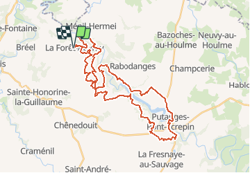
Trail Mountain bike of 41 km to be discovered at Normandy, Orne, Putanges-le-Lac. This trail is proposed by tracegps.

Description

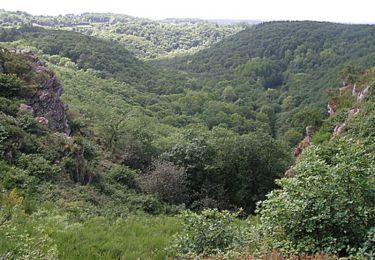
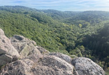
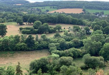
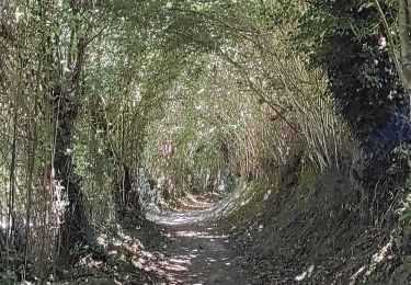
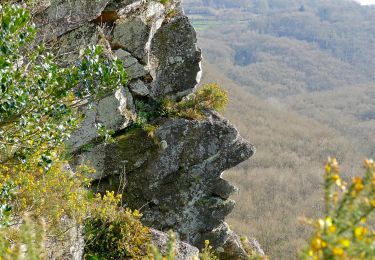
Boucle au départ de La Forêt Auvray. Parcours peu fréquenté le long de la vallée de l'Orne, entre La Forêt Auvray et Putanges-Pont-Ecrepin. Sur ce parcours on est encore en "Suisse Normande" : les dénivelés cumulés sont importants, avec des pourcentages qui parfois obligent à mettre le pied à terre. A 2 reprises on traverse l'Orne à gué (au Vieux St Aubert et au Val d'Orne). Attention En période hivernale ou humide, ces passages à gué ne sont pas praticables. Pour résumer, beau parcours à faire plutôt l'été !

Elevation profile

Positioning

Country:
France
Region :
Normandy
Department/Province :
Orne
Municipality :
Putanges-le-Lac
Location:
La Forêt-Auvray
Start:(UTM)
695152 ; 5409943 (30U) N.

Trails nearby

Trail Walking Saint-Philbert-sur-Orne - Autour des roches d'oetre - Photo
Walking
phi14

Walking

Easy
(3)
Saint-Philbert-sur-Orne, Normandy, Orne, France
9.7 km | 12.4 km-effort
2h 30min
Yes
Trail Walking Athis-Val-de-Rouvre - Rando botanique  - Ségrie Fontaine  - Photo
Walking
tracegps

Walking

Medium
(2)
Athis-Val-de-Rouvre, Normandy, Orne, France
10.4 km | 13.4 km-effort
3h 40min
Yes
Trail Walking Saint-Philbert-sur-Orne - Roche d’oëtre sentier du Granite - Photo
Walking
zefreefly

Walking

Very easy
Saint-Philbert-sur-Orne, Normandy, Orne, France
10.1 km | 12.7 km-effort
2h 43min
Yes
Trail Walking Saint-Philbert-sur-Orne - Circuit des méandres  - Photo
Walking
JLPIERSON

Walking

Medium
Saint-Philbert-sur-Orne, Normandy, Orne, France
6.4 km | 8.4 km-effort
1h 54min
Yes
Trail Walking Ménil-Hubert-sur-Orne - De Rouvroy aux Roches d'Oetre par le sentier des Méandres  - Photo
Walking
Ecureuiltrailer

Walking

Medium
Ménil-Hubert-sur-Orne, Normandy, Orne, France
7.1 km | 9.3 km-effort
2h 1min
Yes
Trail On foot Athis-Val-de-Rouvre - Les Fontaines - Photo
On foot
PRO

On foot

Easy
Athis-Val-de-Rouvre, Normandy, Orne, France
5.7 km | 7.3 km-effort
1h 38min
Yes
Trail On foot Athis-Val-de-Rouvre - Sentier du granite - Photo
On foot
PRO

On foot

Easy
(1)
Athis-Val-de-Rouvre, Normandy, Orne, France
8.6 km | 11 km-effort
2h 30min
Yes
Trail On foot Saint-Philbert-sur-Orne - Entre Orne et Rouvre - Photo
On foot
PRO

On foot

Easy
Saint-Philbert-sur-Orne, Normandy, Orne, France
7.7 km | 10.3 km-effort
2h 19min
Yes
Trail On foot Ménil-Vin - Circuit des Saulces - Photo
On foot
PRO

On foot

Easy
Ménil-Vin, Normandy, Orne, France
12.4 km | 14.9 km-effort
3h 23min
Yes


Close
My subscriptions