![](/images/other/stat-length.png)
![Trail Walking Landéda - AberWrac'h - Traon Bizin - 4km - Photo](https://media.geolcdn.com/t/1900/400/ext.pjpeg?maxdim=2&url=https%3A%2F%2Fstatic1.geolcdn.com%2Fsiteimages%2Fupload%2Ffiles%2F1553511878bg_sport_marche.png)
AberWrac'h - Traon Bizin - 4km
tracegps
User
![Length](/images/other/stat-length.png)
Length
4.1 km
![Max alt](https://static1.geolcdn.com/siteimages/upload/files/1508320355ic_sort_altitude_max_24dp.png)
Max alt
35 m
![Uphill gradient](https://static1.geolcdn.com/siteimages/upload/files/1508320355ic_sort_den_pos_24dp.png)
Uphill gradient
71 m
![Km-Effort](/images/other/stat-length.png)
Km-Effort
5 km
![Min alt](https://static1.geolcdn.com/siteimages/upload/files/1508320355ic_sort_altitude_min_24dp.png)
Min alt
-3 m
![Downhill gradient](https://static1.geolcdn.com/siteimages/upload/files/1508320355ic_sort_den_neg_24dp.png)
Downhill gradient
73 m
![Boucle](https://static1.geolcdn.com/siteimages/upload/files/16400158638029165_repeat_loop_refresh_sync_direction_icon.png)
Boucle
Yes
Creation date :
2014-12-10 00:00:00.0
Updated on :
2014-12-10 00:00:00.0
![Walking](https://static1.geolcdn.com/sitytour/trail-icons/101.png)
1h00
Difficulty : Medium
![Scan this QR Code to open this trail in the SityTrail application](https://capi.geolives.com/qq0zvz2zws4bq2lad0pu/sitytour/trails/104028/qr.png?size=200)
FREE GPS app for hiking
About
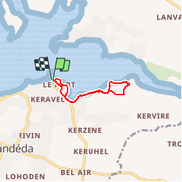
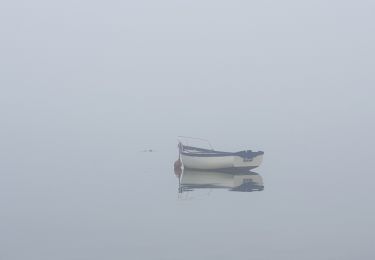
Trail Walking of 4.1 km to be discovered at Brittany, Finistère, Landéda. This trail is proposed by tracegps.
Description
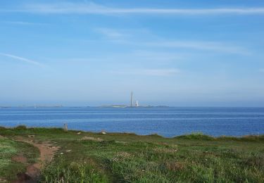
Randonnée pédestre au départ du centre UCPA , pour longer une partie de l'Aber par les petits sentiers du littoral. Retour au milieu des fougères. Panorama très celtique.
Positioning
Country:
France
Region :
Brittany
Department/Province :
Finistère
Municipality :
Landéda
Location:
Unknown
Start:(Dec)
Start:(UTM)
384834 ; 5383924 (30U) N.
Comments
Trails nearby
![Trail Walking Plouguerneau - Boucle Lilia - Perros - Photo](https://media.geolcdn.com/t/375/260/ext.jpg?maxdim=2&url=https%3A%2F%2Fservices.sitytrail.com%2FGeolivesWS%2FDownloadMedia.ashx%3FTrailID%3D462854%26Media%3Dfix__20150823120806.jpg)
![Walking Walking](https://static1.geolcdn.com/sitytour/trail-icons/101.png)
Boucle Lilia - Perros
Walking
Easy
(2)
Plouguerneau,
Brittany,
Finistère,
France
![](/images/other/stat-length.png)
9.7 km | 10.8 km-effort
2h 10min
![](https://static1.geolcdn.com/siteimages/upload/files/16400158638029165_repeat_loop_refresh_sync_direction_icon.png)
Yes
![Trail Walking Landéda - 06.09.24 Landéda -- Treglonou (Touzilit) - Photo](https://media.geolcdn.com/t/375/260/ext.jpg?maxdim=2&url=https%3A%2F%2Fmedia.geolcdn.com%2Ff%2Fec11815a-c8fb-467a-9689-1ba3e69aa97c.jpg)
![Walking Walking](https://static1.geolcdn.com/sitytour/trail-icons/101.png)
06.09.24 Landéda -- Treglonou (Touzilit)
Walking
Very difficult
Landéda,
Brittany,
Finistère,
France
![](/images/other/stat-length.png)
24 km | 28 km-effort
6h 15min
![](https://static1.geolcdn.com/siteimages/upload/files/16400158638029165_repeat_loop_refresh_sync_direction_icon.png)
No
![Trail Walking Plouguerneau - 05.09.23 Lilia -- Landéda - Photo](https://media.geolcdn.com/t/375/260/ext.jpg?maxdim=2&url=https%3A%2F%2Fmedia.geolcdn.com%2Ff%2Fc7c06625-49c8-4c0c-abbd-b4fc835862db.jpg)
![Walking Walking](https://static1.geolcdn.com/sitytour/trail-icons/101.png)
05.09.23 Lilia -- Landéda
Walking
Very difficult
Plouguerneau,
Brittany,
Finistère,
France
![](/images/other/stat-length.png)
17.1 km | 21 km-effort
4h 43min
![](https://static1.geolcdn.com/siteimages/upload/files/16400158638029165_repeat_loop_refresh_sync_direction_icon.png)
No
![Trail Bicycle tourism Plouguerneau - St Michel à St Pabu - Photo](https://media.geolcdn.com/t/375/260/ext.jpg?maxdim=2&url=https%3A%2F%2Fmedia.geolcdn.com%2Ff%2F20ce82cb-3f5c-494c-b024-433b8cba4612.jpg)
![Bicycle tourism Bicycle tourism](https://static1.geolcdn.com/sitytour/trail-icons/204.png)
St Michel à St Pabu
Bicycle tourism
Medium
Plouguerneau,
Brittany,
Finistère,
France
![](/images/other/stat-length.png)
55 km | 63 km-effort
5h 2min
![](https://static1.geolcdn.com/siteimages/upload/files/16400158638029165_repeat_loop_refresh_sync_direction_icon.png)
No
![Trail sport Saint-Pabu - Évite - Photo](https://media.geolcdn.com/t/375/260/ext.jpg?maxdim=2&url=https%3A%2F%2Fmedia.geolcdn.com%2Ff%2F101fdcc4-fb1b-4fe5-9c4a-e5d4fec89aac.jpg)
![Trail Walking Plouguerneau - penn ene - Photo](https://media.geolcdn.com/t/375/260/ext.jpg?maxdim=2&url=https%3A%2F%2Fmedia.geolcdn.com%2Ff%2F097291d7-0183-478d-b81a-b95562effd36.jpg)
![Walking Walking](https://static1.geolcdn.com/sitytour/trail-icons/101.png)
![Trail Nordic walking Landéda - Abers vrac Aber Benoît - Photo](https://media.geolcdn.com/t/375/260/ext.jpg?maxdim=2&url=https%3A%2F%2Fmedia.geolcdn.com%2Ff%2F4710018b-ab0b-4599-9439-cb1eef86434c.jpg)
![Nordic walking Nordic walking](https://static1.geolcdn.com/sitytour/trail-icons/102.png)
Abers vrac Aber Benoît
Nordic walking
Very easy
Landéda,
Brittany,
Finistère,
France
![](/images/other/stat-length.png)
18.8 km | 21 km-effort
3h 0min
![](https://static1.geolcdn.com/siteimages/upload/files/16400158638029165_repeat_loop_refresh_sync_direction_icon.png)
Yes
![Trail Walking Tréglonou - Tréglonou - Portsall - Photo](https://media.geolcdn.com/t/375/260/ext.jpg?maxdim=2&url=https%3A%2F%2Fmedia.geolcdn.com%2Ff%2Fc7d22bff-e37f-446d-a165-127937e8fd08.jpg)
![Walking Walking](https://static1.geolcdn.com/sitytour/trail-icons/101.png)
Tréglonou - Portsall
Walking
Easy
Tréglonou,
Brittany,
Finistère,
France
![](/images/other/stat-length.png)
22 km | 0 m-effort
5h 44min
![](https://static1.geolcdn.com/siteimages/upload/files/16400158638029165_repeat_loop_refresh_sync_direction_icon.png)
No
![Trail Walking Landéda - Aber Wrac'h - Photo](https://media.geolcdn.com/t/375/260/ext.jpg?maxdim=2&url=https%3A%2F%2Fmedia.geolcdn.com%2Ff%2F7b637bde-55c1-41b8-9681-f16bd1ae981d.jpg)
![Walking Walking](https://static1.geolcdn.com/sitytour/trail-icons/101.png)
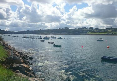
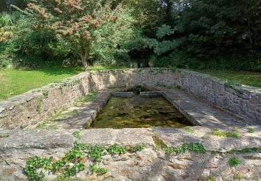
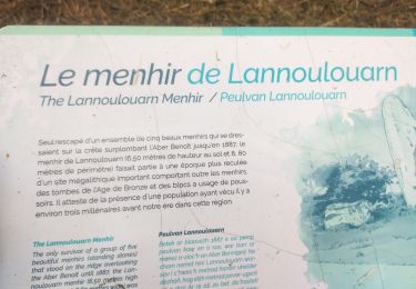
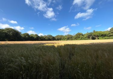
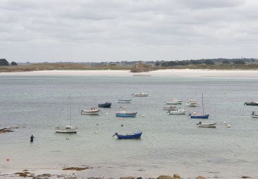
une bonne synthèse des Abers : port, sous bois, campagne et mer.