


mesnil hubert vrai

UDGI54
User

Length
28 km

Max alt
231 m

Uphill gradient
508 m
Km-Effort
34 km

Min alt
48 m

Downhill gradient
506 m
Boucle
Yes
Creation date :
2019-01-15 16:42:30.644
Updated on :
2019-01-15 16:42:30.644
6h00
Difficulty : Medium

FREE GPS app for hiking
 SityTrail
IGN / Geographical institutes
SityTrail Plus
The world is yours!
About
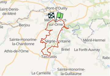
Trail Walking of 28 km to be discovered at Normandy, Orne, Ménil-Hubert-sur-Orne. This trail is proposed by UDGI54.
Positioning
Country:
France
Region :
Normandy
Department/Province :
Orne
Municipality :
Ménil-Hubert-sur-Orne
Location:
Unknown
Start:(Dec)
Start:(UTM)
689843 ; 5414333 (30U) N.
Comments