


SEGRIE 2018 DEF

UDGI54
User
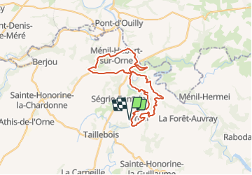

Length
28 km

Max alt
248 m

Uphill gradient
666 m
Km-Effort
37 km

Min alt
48 m

Downhill gradient
666 m
Boucle
Yes
Creation date :
2019-01-15 16:50:00.738
Updated on :
2019-01-15 16:50:00.738
7h52
Difficulty : Difficult

FREE GPS app for hiking
 SityTrail
IGN / Geographical institutes
SityTrail Plus
The world is yours!
About
Trail Walking of 28 km to be discovered at Normandy, Orne, Athis-Val-de-Rouvre. This trail is proposed by UDGI54.
Positioning
Country:
France
Region :
Normandy
Department/Province :
Orne
Municipality :
Athis-Val-de-Rouvre
Location:
Bréel
Start:(Dec)
Start:(UTM)
690994 ; 5409763 (30U) N.
Comments