Trail Cycle Haubourdin - Brevet d'Haubourdin - Photo

Brevet d'Haubourdin

 tracegps
tracegps

User

© OpenStreetMap contributors
Length
Length
89 km
Max alt
Max alt
96 m
Uphill gradient
Uphill gradient
531 m
Km-Effort
Km-Effort  
96 km
Min alt
Min alt
15 m
Downhill gradient
Downhill gradient
527 m
Boucle
Boucle
Yes
Creation date :
2014-12-10 00:00:00.0
Updated on :
2014-12-10 00:00:00.0

(0 Reviews)

Cycle
Cycle
3h30
Difficulty : Medium

Scan this QR Code to open this trail in the SityTrail application

FREE GPS app for hiking

Logo SityTrail SityTrail

IGN / Geographical institutes

Download SityTrail from the App Store Download SityTrail from Google Play

Logo SityTrail SityTrail World

The world is yours!

Download SityTrail from the App Store Download SityTrail from Google Play Download SityTrail on Huawei AppGallery

About

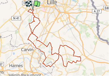
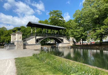
Trail Cycle of 89 km to be discovered at Hauts-de-France, Nord, Haubourdin. This trail is proposed by tracegps.

Description

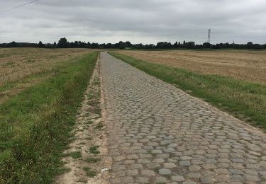
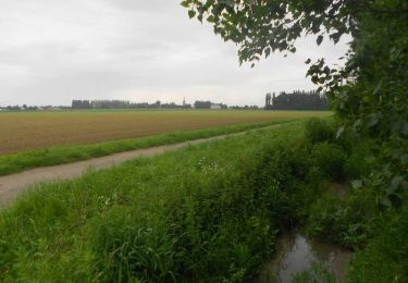
Circuit du brevet "La Ronde des Copains" organisé par : "LES COPAINS CARGILL" (anciennement Cerestar). Le circuit monte deux fois à Mons en Pévèle.

Elevation profile

Photos

Positioning

Country:
France
Region :
Hauts-de-France
Department/Province :
Nord
Municipality :
Haubourdin
Location:
Unknown
Start:(Dec)
Start:(UTM)
498946 ; 5606139 (31U) N.

Trails nearby

Trail Walking Lille - Autour de la citadelle - Photo
Walking

Walking

Very easy
(2)
Lille, Hauts-de-France, Nord, France
5.5 km | 6.1 km-effort
Unknown
Yes
Trail Walking Lille - Autour de la citadelle de Lille - Photo
Walking
tracegps

Walking

Easy
(2)
Lille, Hauts-de-France, Nord, France
5.6 km | 6.3 km-effort
1h 30min
Yes
Trail Walking Wattignies - Autour des champs captants (Wattignies) - Photo
Walking
tracegps

Walking

Medium
(1)
Wattignies, Hauts-de-France, Nord, France
12.2 km | 13.1 km-effort
3h 15min
Yes
Trail Walking Santes - santes - Photo
Walking
phil.monier

Walking

Very easy
(1)
Santes, Hauts-de-France, Nord, France
4.6 km | 5.1 km-effort
1h 7min
No
Trail Walking Lille - Lille 9,5 km - Photo
Walking
GUIDE
rvapeldo

Walking

Easy
Lille, Hauts-de-France, Nord, France
10.3 km | 11.3 km-effort
4h 24min
Yes
Trail Walking Lille - Lille Citadelle parcs remparts centre 12,5  km - Photo
Walking
GUIDE
rvapeldo

Walking

Easy
Lille, Hauts-de-France, Nord, France
13.2 km | 14.5 km-effort
4h 53min
Yes
Trail On foot Lille - circuit des Remparts lille - Photo
On foot
dehemjacques

On foot

Easy
Lille, Hauts-de-France, Nord, France
17.3 km | 19.4 km-effort
4h 24min
Yes
Trail Mountain bike Hallennes-lez-Haubourdin - Haubourdin - Beaucamps - Photo
Mountain bike
Poutape

Mountain bike

Medium
Hallennes-lez-Haubourdin, Hauts-de-France, Nord, France
26 km | 27 km-effort
1h 39min
Yes
Trail Walking Beaucamps-Ligny - Autour de Beaucamps-Ligny  - Photo
Walking
tracegps

Walking

Medium
Beaucamps-Ligny, Hauts-de-France, Nord, France
12.8 km | 13.8 km-effort
3h 10min
Yes


Close
My subscriptions