Trail Running Désaignes - Trail  l'Ardéchois 34km - édition 2010 - Photo

Trail l'Ardéchois 34km - édition 2010

 tracegps
tracegps

User

© OpenStreetMap contributors
Length
Length
36 km
Max alt
Max alt
1184 m
Uphill gradient
Uphill gradient
1536 m
Km-Effort
Km-Effort  
56 km
Min alt
Min alt
467 m
Downhill gradient
Downhill gradient
1540 m
Boucle
Boucle
Yes
Creation date :
2014-12-10 00:00:00.0
Updated on :
2014-12-10 00:00:00.0

(0 Reviews)

Running
Running
5h00
Difficulty : Difficult

Scan this QR Code to open this trail in the SityTrail application

FREE GPS app for hiking

Logo SityTrail SityTrail

IGN / Geographical institutes

Download SityTrail from the App Store Download SityTrail from Google Play

Logo SityTrail SityTrail World

The world is yours!

Download SityTrail from the App Store Download SityTrail from Google Play Download SityTrail on Huawei AppGallery

About

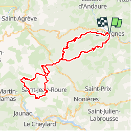
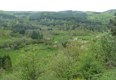
Trail Running of 36 km to be discovered at Auvergne-Rhône-Alpes, Ardèche, Désaignes. This trail is proposed by tracegps.

Description

Le trail désormais classique au départ de Desaigne, petit village médiéval au cœur de l'Ardèche. Le départ des trails 57km et 34km est commun. Il s'agit ici du tracé de 34km (qui, pour l'anecdote en mesure 36). Le circuit est très majoritairement roulant bien qu'il faille avaler les 1500m de dénivelé! Voir aussi le site du Trail l'Ardéchois.

Elevation profile

Photos

Positioning

Country:
France
Region :
Auvergne-Rhône-Alpes
Department/Province :
Ardèche
Municipality :
Désaignes
Location:
Unknown
Start:(UTM)
619527 ; 4983517 (31T) N.

Trails nearby

Trail Walking Saint-Jeure-d'Andaure - En pays d'Andaure - Photo
Walking
tracegps

Walking

Medium
(1)
Saint-Jeure-d'Andaure, Auvergne-Rhône-Alpes, Ardèche, France
6.8 km | 10.1 km-effort
2h 30min
Yes
Trail sport Lamastre - Lamastre Montreynaud - Photo
sport
alinetpierre

sport

Very easy
Lamastre, Auvergne-Rhône-Alpes, Ardèche, France
17.7 km | 26 km-effort
Unknown
Yes
Trail sport Lamastre - Lamastre Desaignes - Photo
sport
alinetpierre

sport

Very easy
Lamastre, Auvergne-Rhône-Alpes, Ardèche, France
21 km | 29 km-effort
Unknown
Yes
Trail Walking Lamastre - urbilhac  - Photo
Walking
brigitte07

Walking

Very easy
(1)
Lamastre, Auvergne-Rhône-Alpes, Ardèche, France
6.5 km | 9.6 km-effort
1h 58min
Yes
Trail Walking Nozières - Col du Buisson - Nozières - Photo
Walking
tracegps

Walking

Medium
Nozières, Auvergne-Rhône-Alpes, Ardèche, France
12 km | 18 km-effort
3h 30min
Yes
Trail Mountain bike Désaignes - Autour de Combeneyre - Désaignes - Photo
Mountain bike
tracegps

Mountain bike

Medium
Désaignes, Auvergne-Rhône-Alpes, Ardèche, France
13.1 km | 18.3 km-effort
1h 30min
Yes
Trail Walking Désaignes - Autour de Combeneyre - Désaignes - Photo
Walking
tracegps

Walking

Medium
Désaignes, Auvergne-Rhône-Alpes, Ardèche, France
13.1 km | 18.3 km-effort
3h 0min
Yes
Trail Walking Désaignes - Autour de Sialle - Désaignes - Photo
Walking
tracegps

Walking

Difficult
Désaignes, Auvergne-Rhône-Alpes, Ardèche, France
8.4 km | 13.5 km-effort
3h 30min
Yes
Trail Walking Désaignes - La Terrasse - Désaignes - Photo
Walking
tracegps

Walking

Medium
Désaignes, Auvergne-Rhône-Alpes, Ardèche, France
13.3 km | 21 km-effort
4h 0min
Yes


Close
My subscriptions