Trail Walking Castéra-Loubix - casteraloubixM1 - Photo
© OpenStreetMap contributors
Length
Length
9.3 km
Max alt
Max alt
329 m
Uphill gradient
Uphill gradient
256 m
Km-Effort
Km-Effort  
12.7 km
Min alt
Min alt
227 m
Downhill gradient
Downhill gradient
257 m
Boucle
Boucle
Yes
Creation date :
2019-01-15 17:07:58.902
Updated on :
2019-01-15 17:07:58.902

(0 Reviews)

Walking
Walking
2h41
Difficulty : Unknown

Scan this QR Code to open this trail in the SityTrail application

FREE GPS app for hiking

Logo SityTrail SityTrail

IGN / Geographical institutes

Download SityTrail from the App Store Download SityTrail from Google Play

Logo SityTrail SityTrail World

The world is yours!

Download SityTrail from the App Store Download SityTrail from Google Play Download SityTrail on Huawei AppGallery

About

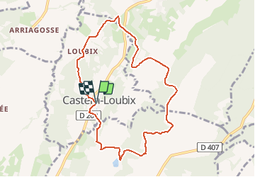
Trail Walking of 9.3 km to be discovered at New Aquitaine, Pyrénées-Atlantiques, Castéra-Loubix. This trail is proposed by LouisROGER.

Description

éviter la descente dans le bois
le chemin à gauche au lieudit Tausière a disparu

Elevation profile

Positioning

Country:
France
Region :
New Aquitaine
Department/Province :
Pyrénées-Atlantiques
Municipality :
Castéra-Loubix
Location:
Unknown
Start:(UTM)
740164 ; 4809752 (30T) N.

Trails nearby

Trail Walking Bentayou-Sérée - LUCARE / ABERRE GR653A premier tronçon du secteur A 2801487 - Photo
Walking
GUIDE
marmotte65

Walking

Difficult
Bentayou-Sérée, New Aquitaine, Pyrénées-Atlantiques, France
11.7 km | 15.2 km-effort
3h 8min
No
Trail Walking Pontiacq-Viellepinte - Pontiac RS - Photo
Walking
LouisROGER

Walking

Very easy
Pontiacq-Viellepinte, New Aquitaine, Pyrénées-Atlantiques, France
4.2 km | 4.6 km-effort
1h 53min
Yes
Trail Walking Vic-en-Bigorre - Vic en Bigorre - Ladevèse et Sannous - Photo
Walking
marcel.F

Walking

Easy
Vic-en-Bigorre, Occitania, Hautespyrenees, France
8.3 km | 10 km-effort
1h 54min
Yes
Trail Walking Lamayou - Lamayou - Peyraube et Lalaye - Photo
Walking
marcel.F

Walking

Difficult
Lamayou, New Aquitaine, Pyrénées-Atlantiques, France
10.7 km | 12.6 km-effort
2h 51min
Yes
Trail Walking Vic-en-Bigorre - Vic en Bigorre - La Côte variante 2  - Photo
Walking
marcel.F

Walking

Medium
Vic-en-Bigorre, Occitania, Hautespyrenees, France
5.8 km | 8.5 km-effort
1h 36min
Yes
Trail Walking Saint-Lézer - Saint Lezer - La Rouquere version1 - Photo
Walking
marcel.F

Walking

Medium
Saint-Lézer, Occitania, Hautespyrenees, France
7.4 km | 9.1 km-effort
1h 40min
Yes
Trail Mountain bike Saint-Lézer - VTT SAINT LEZER CAIXON - Photo
Mountain bike
freddany

Mountain bike

Medium
Saint-Lézer, Occitania, Hautespyrenees, France
20 km | 26 km-effort
1h 47min
Yes
Trail Walking Vic-en-Bigorre - Vic en Bigorre - Tausière version 2 - Photo
Walking
marcel.F

Walking

Medium
Vic-en-Bigorre, Occitania, Hautespyrenees, France
12 km | 15.2 km-effort
2h 42min
Yes
Trail Walking Larreule - Larreule Parrabère - bois de Larreule et de Labatut - Photo
Walking
marcel.F

Walking

Medium
Larreule, Occitania, Hautespyrenees, France
16.2 km | 19.7 km-effort
4h 10min
Yes


Close
My subscriptions