Trail Walking Oloron-Sainte-Marie - Chemin d'Arles à Compostelle - Oloron Ste Marie - Sarrance - Photo

Chemin d'Arles à Compostelle - Oloron Ste Marie - Sarrance

 tracegps
tracegps

User

© OpenStreetMap contributors
Length
Length
22 km
Max alt
Max alt
360 m
Uphill gradient
Uphill gradient
500 m
Km-Effort
Km-Effort  
28 km
Min alt
Min alt
214 m
Downhill gradient
Downhill gradient
369 m
Boucle
Boucle
No
Creation date :
2014-12-10 00:00:00.0
Updated on :
2014-12-10 00:00:00.0

(0 Reviews)

Walking
Walking
5h30
Difficulty : Medium

Scan this QR Code to open this trail in the SityTrail application

FREE GPS app for hiking

Logo SityTrail SityTrail

IGN / Geographical institutes

Download SityTrail from the App Store Download SityTrail from Google Play

Logo SityTrail SityTrail World

The world is yours!

Download SityTrail from the App Store Download SityTrail from Google Play Download SityTrail on Huawei AppGallery

About

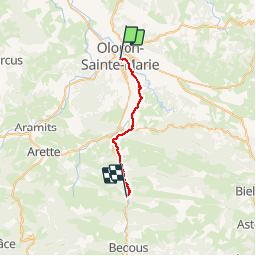
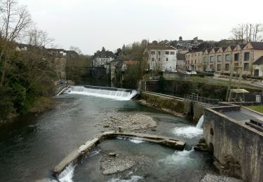
Trail Walking of 22 km to be discovered at New Aquitaine, Pyrénées-Atlantiques, Oloron-Sainte-Marie. This trail is proposed by tracegps.

Description

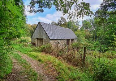
Première étape. Après Oloron se pose la question de deux ou trois étapes jusqu'au Somport. Chacun fera selon sa forme et son appréhension. Mais il faut savoir que la remontée de la vallée d'Aspe est très progressive et que seules les deux dernières heures présentent quelques difficultés. On peut aussi faire le choix d'emprunter la navette SNCF pour éviter de marcher le long de la N134 (gros trafic de poids-lourds). (source Chemin d'Arles)

Elevation profile

Photos

Positioning

Country:
France
Region :
New Aquitaine
Department/Province :
Pyrénées-Atlantiques
Municipality :
Oloron-Sainte-Marie
Location:
Unknown
Start:(UTM)
694112 ; 4784576 (30T) N.

Trails nearby

Trail Running Oloron-Sainte-Marie - OLORON Le camp de Cesar G4
Running
GUIDE
marmotte65

Running

Very easy
Oloron-Sainte-Marie, New Aquitaine, Pyrénées-Atlantiques, France
8.7 km | 12.4 km-effort
2h 58min
Yes
Trail On foot Oloron-Sainte-Marie - OLORON / LURBE  - SAINT CHRISTAUD balisage GR 653 balisage - Photo
On foot
GUIDE
marmotte65

On foot

Easy
Oloron-Sainte-Marie, New Aquitaine, Pyrénées-Atlantiques, France
12.9 km | 17.2 km-effort
3h 54min
No
Trail Walking Oloron-Sainte-Marie - 2023 10 12 CHEMIN du PIÉMONT PYRÉNÉEN - 20ème étape 1ere partie  : Oloron-Ste-Marie - Moumour - Orin - Géronce - St Goin - Gëus d’Oloron - l’Hopital st Blaise - Mauléon-Lichare. - Photo
Walking
LEGUE

Walking

Difficult
Oloron-Sainte-Marie, New Aquitaine, Pyrénées-Atlantiques, France
42 km | 54 km-effort
18h 1min
No
Trail Walking Oloron-Sainte-Marie - OLORON ST MARIE Terra aventura    - Photo
Walking
GUIDE
marmotte65

Walking

Very easy
Oloron-Sainte-Marie, New Aquitaine, Pyrénées-Atlantiques, France
4.6 km | 6.1 km-effort
3h 18min
Yes
Trail On foot Oloron-Sainte-Marie - OLORON Ecomobilité
On foot
GUIDE
marmotte65

On foot

Medium
Oloron-Sainte-Marie, New Aquitaine, Pyrénées-Atlantiques, France
15.5 km | 20 km-effort
4h 20min
Yes
Trail Mountain bike Estos - Tour crètes jusqu'à Louvie - Photo
Mountain bike
claudemen

Mountain bike

Very difficult
(1)
Estos, New Aquitaine, Pyrénées-Atlantiques, France
58 km | 70 km-effort
4h 49min
No
Trail Walking Escout - Pont du Diable - Photo
Walking
HaschKnight

Walking

Easy
Escout, New Aquitaine, Pyrénées-Atlantiques, France
5.6 km | 6.6 km-effort
57min
Yes
Trail On foot Oloron-Sainte-Marie - Move - Photo
On foot
GUIDE
marmotte65

On foot

Easy
Oloron-Sainte-Marie, New Aquitaine, Pyrénées-Atlantiques, France
8.4 km | 12.2 km-effort
2h 45min
Yes
Trail Bicycle tourism Oloron-Sainte-Marie - Oloron - St-Palais - Photo
Bicycle tourism
karawatsj

Bicycle tourism

Difficult
Oloron-Sainte-Marie, New Aquitaine, Pyrénées-Atlantiques, France
55 km | 67 km-effort
3h 22min
No


Close
My subscriptions