![](/images/other/stat-length.png)
![Trail Walking Beauvoisin - Le Gros Moure par Bénivay Ollon - Photo](https://media.geolcdn.com/t/1900/400/ext.pjpeg?maxdim=2&url=https%3A%2F%2Fservices.sitytrail.com%2FGeolivesWS%2FDownloadMedia.ashx%3FTrailID%3D105341%26Media%3D9041_3.jpg)
Le Gros Moure par Bénivay Ollon
tracegps
User
![Length](/images/other/stat-length.png)
![Max alt](https://static1.geolcdn.com/siteimages/upload/files/1508320355ic_sort_altitude_max_24dp.png)
![Uphill gradient](https://static1.geolcdn.com/siteimages/upload/files/1508320355ic_sort_den_pos_24dp.png)
![Km-Effort](/images/other/stat-length.png)
![Min alt](https://static1.geolcdn.com/siteimages/upload/files/1508320355ic_sort_altitude_min_24dp.png)
![Downhill gradient](https://static1.geolcdn.com/siteimages/upload/files/1508320355ic_sort_den_neg_24dp.png)
![Boucle](https://static1.geolcdn.com/siteimages/upload/files/16400158638029165_repeat_loop_refresh_sync_direction_icon.png)
![Walking](https://static1.geolcdn.com/sitytour/trail-icons/101.png)
4h00
Difficulty : Medium
![Scan this QR Code to open this trail in the SityTrail application](https://capi.geolives.com/qq0zvz2zws4bq2lad0pu/sitytour/trails/105341/qr.png?size=200)
FREE GPS app for hiking
About
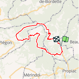
Trail Walking of 16 km to be discovered at Auvergne-Rhône-Alpes, Drôme, Beauvoisin. This trail is proposed by tracegps.
Description
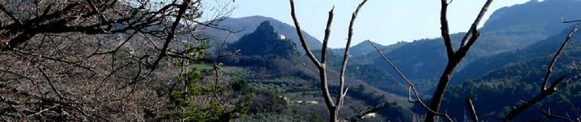
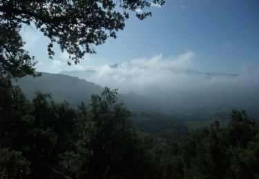
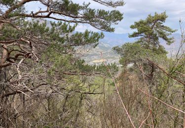
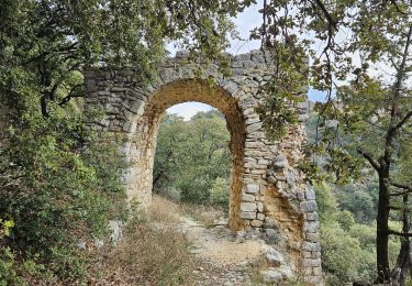
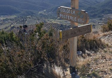
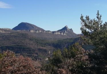
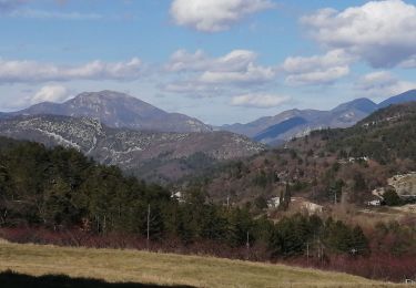
Nous suivons une route peu fréquentée vers la ferme de Font-Jaisse puis continuons la montée vers le pas de Maneyrole que nous laissons sur notre gauche en suivant le Grand Travers pour atteindre le Gros Moure qui sera le point culminant de notre ballade du jour à 811 m. Par une longue descente sur un large sentier entre le ruisseau « Gourbeau » et la Montagne de Buisse, nous nous approchons du joli village de Piégon que nous ne verrons que de loin puisqu’au « Grand Verger » nous reprenons le montée en obliquant vers l’ouest en direction de l’Aiguille Rocher où nous déjeunons. Le paysage que nous découvrons est bien différent de celui que nous avions découvert le 29/10/09 lors d’une randonnée dans ce secteur mais au départ de Piégon. Aujourd’hui, les abricotiers avaient quitté leur feuillage pourpre pour nous offrir leurs dernières fleurs et les toute premières jeunes feuilles. Nous découvrons aussi un balisage surprenant par sa fantaisie et sa nouveauté se superposant au balisage traditionnel recommandé par la FFR ! Un exemple à ne pas suivre ! Quelques photos vous en donneront un aperçu ! Nous reprenons notre progression en montant vers le « Pas de Chauvet » qui nous amène à un étroit sentier descendant vers la « Petite Auzière » puis Benivay-Ollon où nos véhicules nous attendent.
Positioning
Comments
Trails nearby
![Trail Walking Bénivay-Ollon - Balade en Baronnies - Propiac - Photo](https://media.geolcdn.com/t/375/260/ext.jpg?maxdim=2&url=https%3A%2F%2Fservices.sitytrail.com%2FGeolivesWS%2FDownloadMedia.ashx%3FTrailID%3D103777%26Media%3D6544_2.jpg)
![Walking Walking](https://static1.geolcdn.com/sitytour/trail-icons/101.png)
Walking
![](/images/other/stat-length.png)
![](https://static1.geolcdn.com/siteimages/upload/files/16400158638029165_repeat_loop_refresh_sync_direction_icon.png)
![Trail Walking Propiac - Propiac(26) - Photo](https://media.geolcdn.com/t/375/260/ext.jpg?maxdim=2&url=https%3A%2F%2Fstatic1.geolcdn.com%2Fsiteimages%2Fupload%2Ffiles%2F1553511878bg_sport_marche.png)
![Walking Walking](https://static1.geolcdn.com/sitytour/trail-icons/101.png)
Walking
![](/images/other/stat-length.png)
![](https://static1.geolcdn.com/siteimages/upload/files/16400158638029165_repeat_loop_refresh_sync_direction_icon.png)
![Trail Walking Piégon - Piegon les géants moins dur - Photo](https://media.geolcdn.com/t/375/260/ext.jpg?maxdim=2&url=https%3A%2F%2Fmedia.geolcdn.com%2Ff%2Fd32a1bd2-8353-472c-b62f-28b31d928b46.jpg)
![Walking Walking](https://static1.geolcdn.com/sitytour/trail-icons/101.png)
Walking
![](/images/other/stat-length.png)
![](https://static1.geolcdn.com/siteimages/upload/files/16400158638029165_repeat_loop_refresh_sync_direction_icon.png)
![Trail Walking Châteauneuf-de-Bordette - Chateauneuf de Bordette - Montagne de Petitjeux - Photo](https://media.geolcdn.com/t/375/260/ext.jpg?maxdim=2&url=https%3A%2F%2Fstatic1.geolcdn.com%2Fsiteimages%2Fupload%2Ffiles%2F1553511878bg_sport_marche.png)
![Walking Walking](https://static1.geolcdn.com/sitytour/trail-icons/101.png)
Walking
![](/images/other/stat-length.png)
![](https://static1.geolcdn.com/siteimages/upload/files/16400158638029165_repeat_loop_refresh_sync_direction_icon.png)
![Trail Walking Mérindol-les-Oliviers - Merindole pour essai - Photo](https://media.geolcdn.com/t/375/260/ext.jpg?maxdim=2&url=https%3A%2F%2Fmedia.geolcdn.com%2Ff%2Fa6836570-77d4-4e38-9a27-7d136fae0143.jpg)
![Walking Walking](https://static1.geolcdn.com/sitytour/trail-icons/101.png)
Walking
![](/images/other/stat-length.png)
![](https://static1.geolcdn.com/siteimages/upload/files/16400158638029165_repeat_loop_refresh_sync_direction_icon.png)
![Trail Walking Bénivay-Ollon - Benyvai olon - Photo](https://media.geolcdn.com/t/375/260/ext.jpg?maxdim=2&url=https%3A%2F%2Fmedia.geolcdn.com%2Ff%2Fb4e75628-8b5a-464c-bc68-2f2b8d19e712.jpg)
![Walking Walking](https://static1.geolcdn.com/sitytour/trail-icons/101.png)
Walking
![](/images/other/stat-length.png)
![](https://static1.geolcdn.com/siteimages/upload/files/16400158638029165_repeat_loop_refresh_sync_direction_icon.png)
![Trail Walking Piégon - piégon par les cretes - Photo](https://media.geolcdn.com/t/375/260/ext.jpg?maxdim=2&url=https%3A%2F%2Fmedia.geolcdn.com%2Ff%2F61a526b4-431f-4671-a68a-d9c2f543adfe.jpg)
![Walking Walking](https://static1.geolcdn.com/sitytour/trail-icons/101.png)
Walking
![](/images/other/stat-length.png)
![](https://static1.geolcdn.com/siteimages/upload/files/16400158638029165_repeat_loop_refresh_sync_direction_icon.png)
![Trail Walking Châteauneuf-de-Bordette - les crêtes de l essayon - Photo](https://media.geolcdn.com/t/375/260/ext.jpg?maxdim=2&url=https%3A%2F%2Fmedia.geolcdn.com%2Ff%2F0a4afea4-d490-4476-b6fe-d94b38d36315.jpg)
![Walking Walking](https://static1.geolcdn.com/sitytour/trail-icons/101.png)
Walking
![](/images/other/stat-length.png)
![](https://static1.geolcdn.com/siteimages/upload/files/16400158638029165_repeat_loop_refresh_sync_direction_icon.png)
![Trail Walking Rochebrune - les 6 cols - Photo](https://media.geolcdn.com/t/375/260/ext.jpg?maxdim=2&url=https%3A%2F%2Fmedia.geolcdn.com%2Ff%2Fbbb2593f-7173-465e-84e2-3dd19a58f0d2.jpg)
![Walking Walking](https://static1.geolcdn.com/sitytour/trail-icons/101.png)
Walking
![](/images/other/stat-length.png)
![](https://static1.geolcdn.com/siteimages/upload/files/16400158638029165_repeat_loop_refresh_sync_direction_icon.png)