Trail Walking Petit-Croix - Balade Adolphe Pégoud - Petit-Croix - Photo

Balade Adolphe Pégoud - Petit-Croix

 tracegps
tracegps

User

© OpenStreetMap contributors
Length
Length
10.8 km
Max alt
Max alt
381 m
Uphill gradient
Uphill gradient
98 m
Km-Effort
Km-Effort  
12.1 km
Min alt
Min alt
340 m
Downhill gradient
Downhill gradient
97 m
Boucle
Boucle
Yes
Creation date :
2014-12-10 00:00:00.0
Updated on :
2014-12-10 00:00:00.0

(0 Reviews)

Walking
Walking
2h45
Difficulty : Medium

Scan this QR Code to open this trail in the SityTrail application

FREE GPS app for hiking

Logo SityTrail SityTrail

IGN / Geographical institutes

Download SityTrail from the App Store Download SityTrail from Google Play

Logo SityTrail SityTrail World

The world is yours!

Download SityTrail from the App Store Download SityTrail from Google Play Download SityTrail on Huawei AppGallery

About

Trail Walking of 10.8 km to be discovered at Bourgogne-Franche-Comté, Territoire-de-Belfort, Petit-Croix. This trail is proposed by tracegps.

Description

Circuit proposé par la Communauté de Communes du Bassin de la Bourbeuse . Départ de Petit Croix, du parking du Mémorial Pégoud en bordure de la D28. 3e enfant d’une famille de paysans le jeune Adolphe délaisse la ferme et s’engage dans l’armée. Mobilisé dès la 1ère guerre mondiale, il est affecté à la défense de Paris. En avril 1915 il rejoint le 2e groupe d’aviation de Reims et obtient 6 victoires aériennes avant d’être abattu le 31 aout 1915 dans le ciel de petit Croix. Un monument commémoratif a été érigé à l’emplacement où s’est écrasé son avion en 1917 Ce monument a été transféré à Petit Croix le 15 mai 1982 et remplacé par une stèle. Retrouvez ce circuit sur le site de la communauté de communes du Bassin de la Bourbeuse.

Elevation profile

Photos

Positioning

Country:
France
Region :
Bourgogne-Franche-Comté
Department/Province :
Territoire-de-Belfort
Municipality :
Petit-Croix
Location:
Unknown
Start:(UTM)
347824 ; 5275358 (32T) N.

Trails nearby

Trail Walking Foussemagne - Balade de l'étang de la Marnière - Foussemagne - Photo
Walking
tracegps

Walking

Easy
(1)
Foussemagne, Bourgogne-Franche-Comté, Territoire-de-Belfort, France
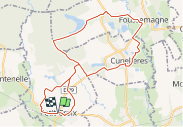
6.8 km | 7.4 km-effort
1h 45min
Yes
Trail Mountain bike Vézelois - 1er tour avec Olivier - Photo
Mountain bike
jibus90

Mountain bike

Easy
(1)
Vézelois, Bourgogne-Franche-Comté, Territoire-de-Belfort, France
38 km | 47 km-effort
2h 59min
Yes
Trail Walking Montreux-Château - Montreux - Valdieu - Photo
Walking
Papamoju

Walking

Easy
Montreux-Château, Bourgogne-Franche-Comté, Territoire-de-Belfort, France
12.8 km | 14.2 km-effort
3h 15min
Yes
Trail Walking Bessoncourt - rando bessoncourt frais - Photo
Walking
azathot100

Walking

Very easy
Bessoncourt, Bourgogne-Franche-Comté, Territoire-de-Belfort, France
6 km | 6.8 km-effort
2h 6min
Yes
Trail Walking Bessoncourt - rando bessoncourt frais - Photo
Walking
azathot100

Walking

Very easy
Bessoncourt, Bourgogne-Franche-Comté, Territoire-de-Belfort, France
6 km | 6.8 km-effort
2h 6min
Yes
Trail Walking Chavannes-les-Grands - Circuit de Chavannes les Grands - Photo
Walking
tracegps

Walking

Easy
Chavannes-les-Grands, Bourgogne-Franche-Comté, Territoire-de-Belfort, France
6.8 km | 7.6 km-effort
1h 45min
Yes
Trail Walking Autrechêne - Boucle du Chêne d'Autrage - Autrechêne - Photo
Walking
tracegps

Walking

Medium
Autrechêne, Bourgogne-Franche-Comté, Territoire-de-Belfort, France
8.3 km | 9.3 km-effort
2h 15min
Yes
Trail Walking Montreux-Château - Boucle du Courlis - Montreux-Château - Photo
Walking
tracegps

Walking

Difficult
Montreux-Château, Bourgogne-Franche-Comté, Territoire-de-Belfort, France
12.6 km | 13.8 km-effort
3h 10min
Yes
Trail Walking Novillard - Boucle de la Madeleine - Novillard - Photo
Walking
tracegps

Walking

Medium
Novillard, Bourgogne-Franche-Comté, Territoire-de-Belfort, France
12.2 km | 14 km-effort
3h 0min
Yes


Close
My subscriptions