Trail Mountain bike Saint-Pierre-la-Bruyère - Randonnée à Saint Pierre la Bruyère - Photo

Randonnée à Saint Pierre la Bruyère

 tracegps
tracegps

User

© OpenStreetMap contributors
Length
Length
15.4 km
Max alt
Max alt
224 m
Uphill gradient
Uphill gradient
293 m
Km-Effort
Km-Effort  
19.3 km
Min alt
Min alt
107 m
Downhill gradient
Downhill gradient
296 m
Boucle
Boucle
Yes
Creation date :
2014-12-10 00:00:00.0
Updated on :
2014-12-10 00:00:00.0

(1 Reviews)

Mountain bike
Mountain bike
1h15
Difficulty : Medium

Scan this QR Code to open this trail in the SityTrail application

FREE GPS app for hiking

Logo SityTrail SityTrail

IGN / Geographical institutes

Download SityTrail from the App Store Download SityTrail from Google Play

Logo SityTrail SityTrail World

The world is yours!

Download SityTrail from the App Store Download SityTrail from Google Play Download SityTrail on Huawei AppGallery

About

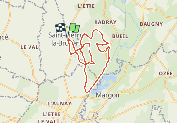
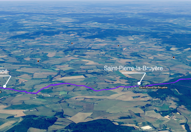
Trail Mountain bike of 15.4 km to be discovered at Normandy, Orne, Saint-Pierre-la-Bruyère. This trail is proposed by tracegps.

Description

Départ du petit village. On pénètre rapidement dans le bois on en ressort 15 km plus loin. Retour au village par la route sur 1 km. Pas de difficultés particulières. Une bonne oxygénation.

Elevation profile

Photos

Positioning

Country:
France
Region :
Normandy
Department/Province :
Orne
Municipality :
Saint-Pierre-la-Bruyère
Location:
Unknown
Start:(UTM)
337458 ; 5358852 (31U) N.

Comments

Please log in to post a review or rate the element


2/3 impraticable à éviter , ronces orties herbes a 1m80 non entretenu à éviter !!!


Trails nearby

Trail Walking Sablons sur Huisne - Villeray, au Fil de l'Huisne 11.8 Km - Photo
Walking
ODDAD78

Walking

Difficult
(1)
Sablons sur Huisne, Normandy, Orne, France
12.6 km | 14.7 km-effort
3h 20min
Yes
Trail Walking Sablons sur Huisne - Condé Les Sablons, vallée de l'Huisne - Photo
Walking
jeannine grandjean

Walking

Difficult
Sablons sur Huisne, Normandy, Orne, France
13.1 km | 15.1 km-effort
3h 25min
Yes
Trail Walking Nogent-le-Rotrou - NOGENT LE ROTROU - Photo
Walking
jeannine grandjean

Walking

Medium
Nogent-le-Rotrou, Centre-Loire Valley, Eure-et-Loir, France
5.8 km | 6.9 km-effort
1h 33min
Yes
Trail Walking Verrières - SityTrail - SityTrail - Les Vieilles Trognes 9 Km - Photo
Walking
ODDAD78

Walking

Difficult
Verrières, Normandy, Orne, France
11.4 km | 13.7 km-effort
3h 6min
Yes
Trail Walking Nogent-le-Rotrou - SityTrail - Nogent-le-Rotrou - Saint-Victor-de-Buthon 19 km - Photo
Walking

Walking

Very difficult
Nogent-le-Rotrou, Centre-Loire Valley, Eure-et-Loir, France
19 km | 23 km-effort
5h 5min
No
Trail Walking Berd'huis - SityTrail - Berd'huis - Condé-sur-Huisne 14 km - Photo
Walking
ODDAD78

Walking

Difficult
Berd'huis, Normandy, Orne, France
13.9 km | 16.7 km-effort
3h 37min
No
Trail Walking Berd'huis - SityTrail - Berd'huis - Saint-Cyr-la-Rosière via Préaux-du-Perche 12 km - Photo
Walking

Walking

Very easy
Berd'huis, Normandy, Orne, France
4.1 km | 4.9 km-effort
1h 0min
No
Trail Walking Nogent-le-Rotrou - 10981160-ZProjet Nogent - Thiron 2 - Photo
Walking

Walking

Very difficult
Nogent-le-Rotrou, Centre-Loire Valley, Eure-et-Loir, France
22 km | 26 km-effort
6h 0min
No
Trail Walking Sablons sur Huisne - Condé-sur-Huisne - Coudreceau 12 km - Photo
Walking

Walking

Easy
Sablons sur Huisne, Normandy, Orne, France
12.3 km | 15.3 km-effort
3h 10min
No


Close
My subscriptions