Trail Walking Llo - Llo et la vallée du Sègre - Photo

Llo et la vallée du Sègre

© OpenStreetMap contributors
Length
Length
9.4 km
Max alt
Max alt
1683 m
Uphill gradient
Uphill gradient
375 m
Km-Effort
Km-Effort  
14.4 km
Min alt
Min alt
1383 m
Downhill gradient
Downhill gradient
375 m
Boucle
Boucle
Yes
Creation date :
2014-12-10 00:00:00.0
Updated on :
2014-12-10 00:00:00.0

(1 Reviews)

Walking
Walking
2h52
Difficulty : Easy

Scan this QR Code to open this trail in the SityTrail application

FREE GPS app for hiking

Logo SityTrail SityTrail

IGN / Geographical institutes

Download SityTrail from the App Store Download SityTrail from Google Play

Logo SityTrail SityTrail World

The world is yours!

Download SityTrail from the App Store Download SityTrail from Google Play Download SityTrail on Huawei AppGallery

About

Trail Walking of 9.4 km to be discovered at Occitania, Pyrénées-Orientales, Llo. This trail is proposed by pak.martin.

Description

Balade de 2 h avec un dénivelé de 250 m. On s'est trompé. On a fait demi-tour. On doit tourner à gauche avant le pont après 2,5km

Elevation profile

Photos

Positioning

Country:
France
Region :
Occitania
Department/Province :
Pyrénées-Orientales
Municipality :
Llo
Location:
Unknown
Start:(UTM)
422649 ; 4700542 (31T) N.

Comments

Please log in to post a review or rate the element


Trails nearby

Trail Walking Eyne - Eyne,col de Nuria,pic d'Eyne,Torre d'Eyne,Eyne. - Photo
Walking
Machaon6

Walking

Very difficult
(1)
Eyne, Occitania, Pyrénées-Orientales, France
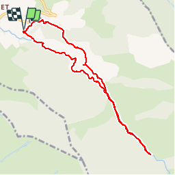
24 km | 43 km-effort
8h 44min
Yes
Trail Walking Eyne - Le Cambre d'Ase - Photo
Walking
tracegps

Walking

Difficult
(1)
Eyne, Occitania, Pyrénées-Orientales, France
8.9 km | 22 km-effort
4h 0min
Yes
Trail Walking Eyne - Vallée d'Eyne - Photo
Walking
GUIDE
nadinebondoux

Walking

Medium
Eyne, Occitania, Pyrénées-Orientales, France
10.7 km | 17.6 km-effort
4h 40min
Yes
Trail Walking Saint-Pierre-dels-Forcats - bains  de St Thomas  - Photo
Walking
Ptitjack30

Walking

Medium
(1)
Saint-Pierre-dels-Forcats, Occitania, Pyrénées-Orientales, France
8.6 km | 12.2 km-effort
2h 42min
No
Trail Walking Eyne - eyne - Photo
Walking
gardelg

Walking

Medium
(2)
Eyne, Occitania, Pyrénées-Orientales, France
6.2 km | 8.2 km-effort
2h 1min
Yes
Trail Walking Eyne - La vallée d'Eyne - Photo
Walking
suresnois

Walking

Difficult
Eyne, Occitania, Pyrénées-Orientales, France
11.2 km | 18 km-effort
7h 8min
Yes
Trail Walking Eyne - 20210722 vallée d’Eyne-Pic de Nuria et Finestrelle - Photo
Walking
ThonyM

Walking

Difficult
Eyne, Occitania, Pyrénées-Orientales, France
21 km | 37 km-effort
5h 56min
Yes
Trail Walking Saillagouse - 20210627 à partir de Saillagouse  - Photo
Walking
ThonyM

Walking

Medium
(1)
Saillagouse, Occitania, Pyrénées-Orientales, France
16.2 km | 26 km-effort
3h 47min
Yes
Trail Trail Font-Romeu-Odeillo-Via - Sortie trail - Photo
Trail
Cedric Pucheux

Trail

Difficult
(1)
Font-Romeu-Odeillo-Via, Occitania, Pyrénées-Orientales, France
11.8 km | 17.8 km-effort
1h 37min
Yes


Close
My subscriptions