


Parcours footing 6

yannick-p
User

Length
10.1 km

Max alt
217 m

Uphill gradient
101 m
Km-Effort
11.4 km

Min alt
167 m

Downhill gradient
99 m
Boucle
Yes
Creation date :
2014-12-10 00:00:00.0
Updated on :
2014-12-10 00:00:00.0
45m
Difficulty : Easy

FREE GPS app for hiking
 SityTrail
IGN / Geographical institutes
SityTrail Plus
The world is yours!
About
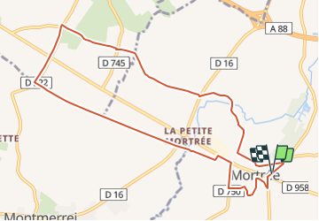
Trail Running of 10.1 km to be discovered at Normandy, Orne, Mortrée. This trail is proposed by yannick-p.
Description
Une petite côte à travers la plaine vers le relais de téléphonie.
Positioning
Country:
France
Region :
Normandy
Department/Province :
Orne
Municipality :
Mortrée
Location:
Mortrée
Start:(Dec)
Start:(UTM)
284963 ; 5391507 (31U) N.
Comments