Trail Walking Saint-Martin-de-l'If - fréville - Photo
© OpenStreetMap contributors
Length
Length
8.7 km
Max alt
Max alt
142 m
Uphill gradient
Uphill gradient
135 m
Km-Effort
Km-Effort  
10.5 km
Min alt
Min alt
43 m
Downhill gradient
Downhill gradient
135 m
Boucle
Boucle
Yes
Creation date :
2014-12-10 00:00:00.0
Updated on :
2014-12-10 00:00:00.0

(0 Reviews)

Walking
Walking
2h17
Difficulty : Medium

Scan this QR Code to open this trail in the SityTrail application

FREE GPS app for hiking

Logo SityTrail SityTrail

IGN / Geographical institutes

Download SityTrail from the App Store Download SityTrail from Google Play

Logo SityTrail SityTrail World

The world is yours!

Download SityTrail from the App Store Download SityTrail from Google Play Download SityTrail on Huawei AppGallery

About

Trail Walking of 8.7 km to be discovered at Normandy, Seine-Maritime, Saint-Martin-de-l'If. This trail is proposed by nicole.reine@wanadoo.fr.

Elevation profile

Positioning

Country:
France
Region :
Normandy
Department/Province :
Seine-Maritime
Municipality :
Saint-Martin-de-l'If
Location:
Unknown
Start:(UTM)
342956 ; 5492943 (31U) N.

Trails nearby

Trail Walking Touffreville-la-Corbeline - Touffreville la Corbeline - Photo
Walking
MichelRando7656

Walking

Difficult
(2)
Touffreville-la-Corbeline, Normandy, Seine-Maritime, France
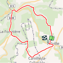
12.4 km | 14.4 km-effort
3h 20min
Yes
Trail Walking Rives-en-Seine - St Wandrille le Rançon - Photo
Walking
tracegps

Walking

Medium
Rives-en-Seine, Normandy, Seine-Maritime, France
13.2 km | 16.8 km-effort
2h 40min
Yes
Trail sport Saint-Martin-de-l'If - 2024-09-09_14h29m54_Cirkwi-Circuit_n°3__Le_Val_au_Cesne - Photo
sport
MichelRando7656

sport

Very easy
Saint-Martin-de-l'If, Normandy, Seine-Maritime, France
8.9 km | 11.1 km-effort
Unknown
Yes
Trail sport Saint-Clair-sur-les-Monts - 2024-09-09_14h28m06_Cirkwi-Circuit_n°4__Chemin_de_Boscol(1) - Photo
sport
MichelRando7656

sport

Very easy
Saint-Clair-sur-les-Monts, Normandy, Seine-Maritime, France
9.9 km | 12.1 km-effort
Unknown
Yes
Trail Walking Rives-en-Seine - st wandrille  - Photo
Walking
Klgmartini@2022

Walking

Difficult
Rives-en-Seine, Normandy, Seine-Maritime, France
12.2 km | 15.1 km-effort
2h 49min
Yes
Trail Walking Rives-en-Seine - saint wandrille variante des yaux par le sentier zones humides - Photo
Walking
nicole.reine@wanadoo.fr

Walking

Difficult
Rives-en-Seine, Normandy, Seine-Maritime, France
9.3 km | 12.2 km-effort
2h 46min
Yes
Trail On foot Rives-en-Seine - circuit des yaux  saint wandrille rançon - Photo
On foot
nicole.reine@wanadoo.fr

On foot

Easy
Rives-en-Seine, Normandy, Seine-Maritime, France
8.4 km | 11.1 km-effort
2h 31min
Yes
Trail Hybrid bike Yvetot - Au fil de la Risle - Photo
Hybrid bike
ves

Hybrid bike

Medium
Yvetot, Normandy, Seine-Maritime, France
178 km | 208 km-effort
Unknown
No
Trail Walking Yvetot - Les Fonds de Saint-Clair - Photo
Walking

Walking

Easy
Yvetot, Normandy, Seine-Maritime, France
13.7 km | 15.7 km-effort
3h 27min
Yes


Close
My subscriptions