Trail Mountain bike Médavy - VTT - Medavy - Photo

VTT - Medavy

© OpenStreetMap contributors
Length
Length
19.8 km
Max alt
Max alt
199 m
Uphill gradient
Uphill gradient
148 m
Km-Effort
Km-Effort  
22 km
Min alt
Min alt
159 m
Downhill gradient
Downhill gradient
148 m
Boucle
Boucle
Yes
Creation date :
2014-12-10 00:00:00.0
Updated on :
2014-12-10 00:00:00.0

(0 Reviews)

Mountain bike
Mountain bike
1h30
Difficulty : Medium

Scan this QR Code to open this trail in the SityTrail application

FREE GPS app for hiking

Logo SityTrail SityTrail

IGN / Geographical institutes

Download SityTrail from the App Store Download SityTrail from Google Play

Logo SityTrail SityTrail Plus

The world is yours!

Download SityTrail from the App Store Download SityTrail from Google Play Download SityTrail on Huawei AppGallery

About

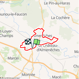
Trail Mountain bike of 19.8 km to be discovered at Normandy, Orne, Médavy. This trail is proposed by yannick-p.

Description

Petit parcours sympathique, en passant par Boissei la Lande, St Hyppolyte, Alménêches puis le Chateau d''Alménêches et retour à Médavy. Le parcours ne présente pas de grande difficulté, sur des petits chemins en grande majorité. Difficile quelques fois de passer après les chevaux en début de trajet, car les trous sont nombreux. Le tracé est assez diversifié, certaines portions ne sont pas fréquentées et l''herbe est assez haute, mais cela passe quand même. Bonne balade à tous ...

Elevation profile

Positioning

Country:
France
Region :
Normandy
Department/Province :
Orne
Municipality :
Médavy
Location:
Unknown
Start:(UTM)
285599 ; 5395691 (31U) N.


Close
My subscriptions