Trail Walking Orcières - Prapic Basset Cabane de la Barre - Photo

Prapic Basset Cabane de la Barre

 Orage
Orage

User

© OpenStreetMap contributors
Length
Length
17.6 km
Max alt
Max alt
2224 m
Uphill gradient
Uphill gradient
921 m
Km-Effort
Km-Effort  
30 km
Min alt
Min alt
1538 m
Downhill gradient
Downhill gradient
921 m
Boucle
Boucle
Yes
Creation date :
2014-12-10 00:00:00.0
Updated on :
2014-12-10 00:00:00.0

(1 Reviews)

Walking
Walking
6h10
Difficulty : Medium

Scan this QR Code to open this trail in the SityTrail application

FREE GPS app for hiking

Logo SityTrail SityTrail

IGN / Geographical institutes

Download SityTrail from the App Store Download SityTrail from Google Play

Logo SityTrail SityTrail World

The world is yours!

Download SityTrail from the App Store Download SityTrail from Google Play Download SityTrail on Huawei AppGallery

About

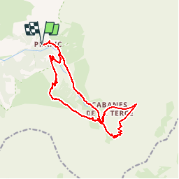
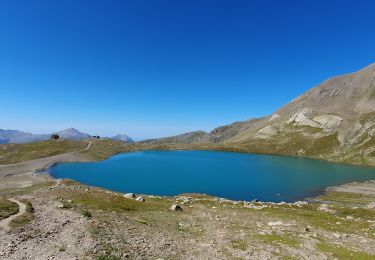
Trail Walking of 17.6 km to be discovered at Provence-Alpes-Côte d'Azur, Hautes-Alpes, Orcières. This trail is proposed by Orage.

Description

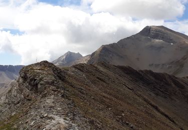
Boucle de 18 km sur 2 jours avec bivouac à la cabane de la Barre :
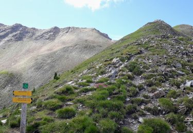
- 4 heures premier jour
- 2 heures 15 min deuxième jour

Elevation profile

Positioning

Country:
France
Region :
Provence-Alpes-Côte d'Azur
Department/Province :
Hautes-Alpes
Municipality :
Orcières
Location:
Unknown
Start:(UTM)
291346 ; 4952215 (32T) N.

Comments

Please log in to post a review or rate the element


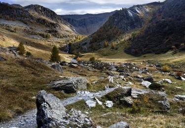
2 jours dans les alpages avec malheureusement moins de marmottes suite à l'avalanche de la fin de cet hiver.


Trails nearby

Trail Walking Orcières - Le Forest des marches - Photo
Walking
GUIDE
nadinebondoux

Walking

Easy
(2)
Orcières, Provence-Alpes-Côte d'Azur, Hautes-Alpes, France
6.3 km | 9.9 km-effort
1h 42min
Yes
Trail Walking Orcières - R45   Marmottes a Prapic - Photo
Walking
GUIDE+

Walking

Medium
(2)
Orcières, Provence-Alpes-Côte d'Azur, Hautes-Alpes, France
9 km | 14 km-effort
2h 57min
Yes
Trail Walking Orcières - Orcieres (Hautes Alpes) - Photo
Walking
ISATR

Walking

Very difficult
(1)
Orcières, Provence-Alpes-Côte d'Azur, Hautes-Alpes, France
12 km | 19.4 km-effort
4h 24min
Yes
Trail Walking Orcières - Roc Diolon par le col de Fressinieres 11/08/23 - Photo
Walking
GUIDE
R@ph

Walking

Very difficult
Orcières, Provence-Alpes-Côte d'Azur, Hautes-Alpes, France
16.3 km | 32 km-effort
7h 21min
Yes
Trail Walking Orcières - Col des Tourettes - Croix Lorraine 08/09/18 - Photo
Walking
GUIDE
R@ph

Walking

Difficult
Orcières, Provence-Alpes-Côte d'Azur, Hautes-Alpes, France
21 km | 37 km-effort
5h 30min
Yes
Trail Walking Orcières - Col de Rouannette 22/07/18 - Photo
Walking
GUIDE
R@ph

Walking

Medium
Orcières, Provence-Alpes-Côte d'Azur, Hautes-Alpes, France
9.3 km | 20 km-effort
3h 56min
Yes
Trail Walking Orcières - 08072013 - Photo
Walking
mikaelerouzic

Walking

Medium
(1)
Orcières, Provence-Alpes-Côte d'Azur, Hautes-Alpes, France
10.5 km | 17.9 km-effort
2h 36min
Yes
Trail Walking Orcières - Merlette Les Lacs - Photo
Walking
frederique.marti@laposte.net

Walking

Easy
(1)
Orcières, Provence-Alpes-Côte d'Azur, Hautes-Alpes, France
18.4 km | 32 km-effort
4h 39min
Yes
Trail Snowshoes Orcières - La recula 31.12.12 - Photo
Snowshoes
Orage

Snowshoes

Medium
(3)
Orcières, Provence-Alpes-Côte d'Azur, Hautes-Alpes, France
11.1 km | 25 km-effort
4h 40min
Yes


Close
My subscriptions