Trail Walking Dompierre - Dompierre longue - Photo

Dompierre longue

© OpenStreetMap contributors
Length
Length
8.3 km
Max alt
Max alt
246 m
Uphill gradient
Uphill gradient
129 m
Km-Effort
Km-Effort  
10 km
Min alt
Min alt
189 m
Downhill gradient
Downhill gradient
130 m
Boucle
Boucle
Yes
Creation date :
2019-05-12 14:09:01.754
Updated on :
2019-06-22 07:26:04.371

(0 Reviews)

Walking
Walking
2h13
Difficulty : Medium

Scan this QR Code to open this trail in the SityTrail application

FREE GPS app for hiking

Logo SityTrail SityTrail

IGN / Geographical institutes

Download SityTrail from the App Store Download SityTrail from Google Play

Logo SityTrail SityTrail World

The world is yours!

Download SityTrail from the App Store Download SityTrail from Google Play Download SityTrail on Huawei AppGallery

About

Trail Walking of 8.3 km to be discovered at Normandy, Orne, Dompierre. This trail is proposed by toporient.

Description

Départ du parking à la sortie ouest de Dompierre sur la RD21 en direction de Donfront.

Elevation profile

Positioning

Country:
France
Region :
Normandy
Department/Province :
Orne
Municipality :
Dompierre
Location:
Unknown
Start:(UTM)
680252 ; 5389488 (30U) N.

Trails nearby

Trail Walking La Ferrière-aux-Étangs - Circuit of IRON by Yannick-p14-61 - Photo
Walking
yannick-p

Walking

Medium
(1)
La Ferrière-aux-Étangs, Normandy, Orne, France
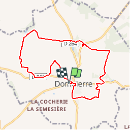
13.3 km | 16.5 km-effort
3h 35min
Yes
Trail Walking La Ferrière-aux-Étangs - La Ferrière - La Ferrière aux Etangs - Photo
Walking
tracegps

Walking

Medium
La Ferrière-aux-Étangs, Normandy, Orne, France
14.3 km | 17.9 km-effort
3h 4min
Yes
Trail Mountain bike  - Espace VTT FFC les Ecureuils du Domfrontais - Circuit n°14 - Champsecret - Photo
Mountain bike
tracegps

Mountain bike

Medium
, Normandy, Orne, France
22 km | 26 km-effort
2h 0min
Yes
Trail Walking La Ferrière-aux-Étangs - 1h16 - Photo
Walking
Jeromefrando

Walking

Medium
La Ferrière-aux-Étangs, Normandy, Orne, France
6.4 km | 8.5 km-effort
1h 16min
Yes
Trail Walking Le Châtellier - chatellier - Photo
Walking
sitydomer

Walking

Medium
Le Châtellier, Normandy, Orne, France
6 km | 6.6 km-effort
1h 36min
Yes
Trail Walking Dompierre - mines - Photo
Walking
canal

Walking

Medium
Dompierre, Normandy, Orne, France
9.3 km | 11.6 km-effort
2h 47min
No
Trail Walking La Ferrière-aux-Étangs - La Feriere aux etant  - Photo
Walking
Elisabeth Neveu

Walking

Very easy
La Ferrière-aux-Étangs, Normandy, Orne, France
1.2 km | 1.3 km-effort
36min
Yes
Trail Walking Dompierre - Dompierre; trace GPS du 10/09/2019 - Photo
Walking
toporient

Walking

Very easy
Dompierre, Normandy, Orne, France
8.2 km | 10.2 km-effort
4h 30min
Yes
Trail Walking Champsecret - Ermitage-Roches aux Dames et aux loups - Photo
Walking
toporient

Walking

Medium
Champsecret, Normandy, Orne, France
9 km | 11 km-effort
2h 23min
Yes


Close
My subscriptions