


2013-06-06_073310

doudet
User
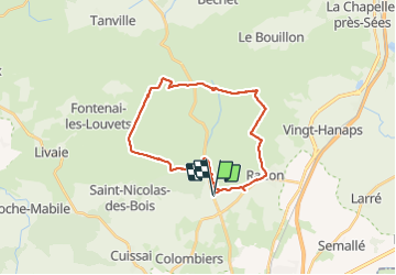

Length
29 km

Max alt
413 m

Uphill gradient
592 m
Km-Effort
37 km

Min alt
178 m

Downhill gradient
588 m
Boucle
Yes
Creation date :
2019-07-02 16:59:26.898
Updated on :
2019-07-02 16:59:26.898
--
Difficulty : Unknown

FREE GPS app for hiking
 SityTrail
IGN / Geographical institutes
SityTrail Plus
The world is yours!
About
Trail Walking of 29 km to be discovered at Normandy, Orne, Écouves. This trail is proposed by doudet.
Positioning
Country:
France
Region :
Normandy
Department/Province :
Orne
Municipality :
Écouves
Location:
Radon
Start:(Dec)
Start:(UTM)
283437 ; 5375512 (31U) N.
Comments