Trail Walking Saint-Preuil - Saint prémilitaire - Photo
 poule16
poule16

User

© OpenStreetMap contributors
Length
Length
9.2 km
Max alt
Max alt
143 m
Uphill gradient
Uphill gradient
144 m
Km-Effort
Km-Effort  
11.1 km
Min alt
Min alt
83 m
Downhill gradient
Downhill gradient
135 m
Boucle
Boucle
Yes
Creation date :
2019-08-08 09:23:12.0
Updated on :
2019-08-08 12:06:04.754

(0 Reviews)

Walking
Walking
2h36
Difficulty : Unknown

Scan this QR Code to open this trail in the SityTrail application

FREE GPS app for hiking

Logo SityTrail SityTrail

IGN / Geographical institutes

Download SityTrail from the App Store Download SityTrail from Google Play

Logo SityTrail SityTrail World

The world is yours!

Download SityTrail from the App Store Download SityTrail from Google Play Download SityTrail on Huawei AppGallery

About

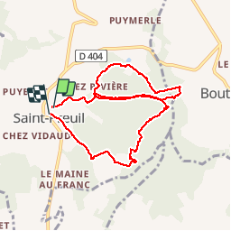
Trail Walking of 9.2 km to be discovered at New Aquitaine, Charente, Saint-Preuil. This trail is proposed by poule16.

Elevation profile

Positioning

Country:
France
Region :
New Aquitaine
Department/Province :
Charente
Municipality :
Saint-Preuil
Location:
Unknown
Start:(UTM)
720647 ; 5053239 (30T) N.

Trails nearby

Trail Motor Saint-Preuil - The Grande Champagne away from beaten track - Photo
Motor
Relais-Saint-Preuil

Motor

Medium
(3)
Saint-Preuil, New Aquitaine, Charente, France
53 km | 63 km-effort
2h 40min
Yes
Trail Walking Bouteville - Bouteville : Sentier des Chaumes Boissieres - Photo
Walking
alfreson

Walking

Bouteville, New Aquitaine, Charente, France
7.7 km | 9.1 km-effort
1h 53min
Yes
Trail Walking Bouteville - Bouteville (16120) - Photo
Walking
dorcier

Walking

Easy
Bouteville, New Aquitaine, Charente, France
14.5 km | 17.6 km-effort
3h 49min
Yes
Trail Quad Lignières-Sonneville - ssv cognac - Photo
Quad
Fabrice Billonnet

Quad

Medium
Lignières-Sonneville, New Aquitaine, Charente, France
83 km | 97 km-effort
3h 46min
Yes
Trail Walking Saint-Preuil - Circuit des fontaines et des lavoirs - Variante balisage Violet - Photo
Walking
neoroll44

Walking

Medium
Saint-Preuil, New Aquitaine, Charente, France
12.8 km | 15.5 km-effort
3h 30min
Yes
Trail Nordic walking Lignières-Sonneville - Lignières Sonneville - Photo
Nordic walking
JACQUOU

Nordic walking

Easy
Lignières-Sonneville, New Aquitaine, Charente, France
14.4 km | 17.7 km-effort
3h 17min
Yes
Trail Walking Angeac-Charente - les indiens  - Photo
Walking
lancelisio

Walking

Very easy
Angeac-Charente, New Aquitaine, Charente, France
4.9 km | 5.6 km-effort
1h 33min
Yes
Trail Walking Segonzac - Autour de Segonzac  - Photo
Walking
jmrobin

Walking

Medium
Segonzac, New Aquitaine, Charente, France
14.6 km | 17.1 km-effort
2h 59min
Yes
Trail Walking Bonneuil - Bonneuil 29-06-2016 - Photo
Walking
jmrobin

Walking

Medium
Bonneuil, New Aquitaine, Charente, France
14.8 km | 18.1 km-effort
3h 21min
Yes


Close
My subscriptions