Trail Walking Bouteville - Bouteville : Sentier des Chaumes Boissieres - Photo

Bouteville : Sentier des Chaumes Boissieres

 alfreson
alfreson

User

© OpenStreetMap contributors
Length
Length
7.7 km
Max alt
Max alt
108 m
Uphill gradient
Uphill gradient
103 m
Km-Effort
Km-Effort  
9.1 km
Min alt
Min alt
45 m
Downhill gradient
Downhill gradient
100 m
Boucle
Boucle
Yes
Creation date :
2020-08-15 08:23:28.0
Updated on :
2020-08-15 10:18:31.586

(0 Reviews)

Walking
Walking
1h53
Difficulty : Unknown
Horseback riding
Horseback riding
--
Difficulty : Unknown

Scan this QR Code to open this trail in the SityTrail application

FREE GPS app for hiking

Logo SityTrail SityTrail

IGN / Geographical institutes

Download SityTrail from the App Store Download SityTrail from Google Play

Logo SityTrail SityTrail World

The world is yours!

Download SityTrail from the App Store Download SityTrail from Google Play Download SityTrail on Huawei AppGallery

About

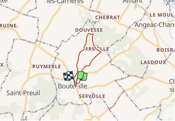
Trail Walking of 7.7 km to be discovered at New Aquitaine, Charente, Bouteville. This trail is proposed by alfreson.

Description

Jolie promenade, facile, au milieu des vignes et des champs de tournesols, avec un petit passage boisé. Au départ, plutôt que prendre la route, prendre l’allée en gazon parallèle à l’accès au château (utilisée ici au retour).

Elevation profile

Photos

Positioning

Country:
France
Region :
New Aquitaine
Department/Province :
Charente
Municipality :
Bouteville
Location:
Unknown
Start:(UTM)
723471 ; 5053550 (30T) N.

Trails nearby

Trail Motor Saint-Preuil - The Grande Champagne away from beaten track - Photo
Motor
Relais-Saint-Preuil

Motor

Medium
(3)
Saint-Preuil, New Aquitaine, Charente, France
53 km | 63 km-effort
2h 40min
Yes
Trail On foot Bellevigne - Chemin Boisné - Photo
On foot
PRO

On foot

Easy
Bellevigne, New Aquitaine, Charente, France
15.6 km | 17 km-effort
3h 51min
No
Trail Walking Bouteville - Bouteville (16120) - Photo
Walking
dorcier

Walking

Easy
Bouteville, New Aquitaine, Charente, France
14.5 km | 17.6 km-effort
3h 49min
Yes
Trail Walking Saint-Preuil - Circuit des fontaines et des lavoirs - Variante balisage Violet - Photo
Walking
neoroll44

Walking

Medium
Saint-Preuil, New Aquitaine, Charente, France
12.8 km | 15.5 km-effort
3h 30min
Yes
Trail Walking Graves-Saint-Amant - Graves St Amand 14-07-2016 - Photo
Walking
jmrobin

Walking

Easy
Graves-Saint-Amant, New Aquitaine, Charente, France
14.6 km | 16.6 km-effort
3h 17min
Yes
Trail Nordic walking Lignières-Sonneville - Lignières Sonneville - Photo
Nordic walking
JACQUOU

Nordic walking

Easy
Lignières-Sonneville, New Aquitaine, Charente, France
14.4 km | 17.7 km-effort
3h 17min
Yes
Trail Walking Mainxe-Gondeville - mainxe - Photo
Walking
sy!

Walking

Very easy
Mainxe-Gondeville, New Aquitaine, Charente, France
12.5 km | 14 km-effort
2h 50min
Yes
Trail Walking Angeac-Charente - les indiens  - Photo
Walking
lancelisio

Walking

Very easy
Angeac-Charente, New Aquitaine, Charente, France
4.9 km | 5.6 km-effort
1h 33min
Yes
Trail Walking Saint-Preuil - Saint prémilitaire - Photo
Walking
poule16

Walking

Saint-Preuil, New Aquitaine, Charente, France
9.2 km | 11.1 km-effort
2h 36min
Yes


Close
My subscriptions