![](/images/other/stat-length.png)
![Trail Touring skiing Valdeblore - Mont Petoumier. Mont Pépoiri - Photo](https://media.geolcdn.com/t/1900/400/ext.pjpeg?maxdim=2&url=https%3A%2F%2Fmedia.geolcdn.com%2Ff%2Fea867d2d-df72-4518-a830-624c286291ff.jpg)
Mont Petoumier. Mont Pépoiri
nadd73
User
![Length](/images/other/stat-length.png)
Length
11.7 km
![Max alt](https://static1.geolcdn.com/siteimages/upload/files/1508320355ic_sort_altitude_max_24dp.png)
Max alt
2658 m
![Uphill gradient](https://static1.geolcdn.com/siteimages/upload/files/1508320355ic_sort_den_pos_24dp.png)
Uphill gradient
1144 m
![Km-Effort](/images/other/stat-length.png)
Km-Effort
27 km
![Min alt](https://static1.geolcdn.com/siteimages/upload/files/1508320355ic_sort_altitude_min_24dp.png)
Min alt
1686 m
![Downhill gradient](https://static1.geolcdn.com/siteimages/upload/files/1508320355ic_sort_den_neg_24dp.png)
Downhill gradient
1143 m
![Boucle](https://static1.geolcdn.com/siteimages/upload/files/16400158638029165_repeat_loop_refresh_sync_direction_icon.png)
Boucle
Yes
Creation date :
2019-12-31 08:59:44.093
Updated on :
2019-12-31 18:30:43.212
![Touring skiing](https://static1.geolcdn.com/sitytour/trail-icons/503.png)
6h45
Difficulty : Medium
![Scan this QR Code to open this trail in the SityTrail application](https://capi.geolives.com/qq0zvz2zws4bq2lad0pu/sitytour/trails/2294242/qr.png?size=200)
FREE GPS app for hiking
About
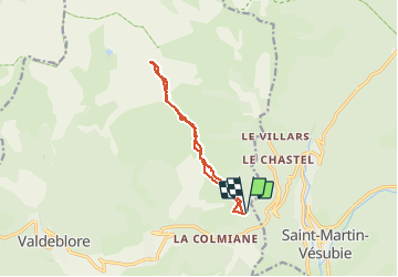
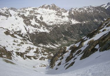
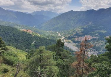
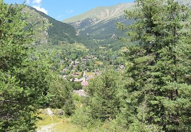
Trail Touring skiing of 11.7 km to be discovered at Provence-Alpes-Côte d'Azur, Maritime Alps, Valdeblore. This trail is proposed by nadd73.
Description
De Colmiane piste via fierrata.
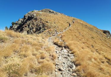
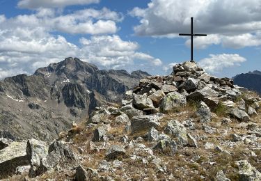
monter au mieux et itinéraire évident. au Mont Pètounier descendre et monter au Mont Pèpoiri.
Descente face sud et remonter vers le Mont Pètounier.
Positioning
Country:
France
Region :
Provence-Alpes-Côte d'Azur
Department/Province :
Maritime Alps
Municipality :
Valdeblore
Location:
Unknown
Start:(Dec)
Start:(UTM)
358429 ; 4881944 (32T) N.
Comments
Trails nearby
![Trail Walking Valdeblore - pepoiri - Photo](https://media.geolcdn.com/t/375/260/ext.jpg?maxdim=2&url=https%3A%2F%2Fmedia.geolcdn.com%2Ff%2F8ca18259-e53b-4625-8dc3-3afb9e53eb6b.jpg)
![Walking Walking](https://static1.geolcdn.com/sitytour/trail-icons/101.png)
pepoiri
Walking
Very easy
(1)
Valdeblore,
Provence-Alpes-Côte d'Azur,
Maritime Alps,
France
![](/images/other/stat-length.png)
7.8 km | 16.3 km-effort
5h 31min
![](https://static1.geolcdn.com/siteimages/upload/files/16400158638029165_repeat_loop_refresh_sync_direction_icon.png)
Yes
![Trail Walking Venanson - La Malouna - Photo](https://media.geolcdn.com/t/375/260/ext.jpg?maxdim=2&url=https%3A%2F%2Fservices.sitytrail.com%2FGeolivesWS%2FDownloadMedia.ashx%3FTrailID%3D405887%26Media%3Dfix__20150409152656.jpg)
![Walking Walking](https://static1.geolcdn.com/sitytour/trail-icons/101.png)
La Malouna
Walking
Medium
(1)
Venanson,
Provence-Alpes-Côte d'Azur,
Maritime Alps,
France
![](/images/other/stat-length.png)
10.7 km | 17.9 km-effort
5h 20min
![](https://static1.geolcdn.com/siteimages/upload/files/16400158638029165_repeat_loop_refresh_sync_direction_icon.png)
Yes
![Trail On foot Valdeblore - Le Caïre Gros - Photo](https://media.geolcdn.com/t/375/260/ext.jpg?maxdim=2&url=https%3A%2F%2Fmedia.geolcdn.com%2Ff%2F3c6df4dd-1089-48da-8830-4c0973863251.jpeg)
![On foot On foot](https://static1.geolcdn.com/sitytour/trail-icons/100.png)
Le Caïre Gros
On foot
Medium
Valdeblore,
Provence-Alpes-Côte d'Azur,
Maritime Alps,
France
![](/images/other/stat-length.png)
9.8 km | 20 km-effort
4h 38min
![](https://static1.geolcdn.com/siteimages/upload/files/16400158638029165_repeat_loop_refresh_sync_direction_icon.png)
Yes
![Trail On foot Saint-Martin-Vésubie - Col de Cerise - Photo](https://media.geolcdn.com/t/375/260/ext.jpg?maxdim=2&url=https%3A%2F%2Fmedia.geolcdn.com%2Ff%2F90b1ce11-d155-4ca1-8f15-a1d1ec21efc7.jpeg)
![On foot On foot](https://static1.geolcdn.com/sitytour/trail-icons/100.png)
Col de Cerise
On foot
Medium
Saint-Martin-Vésubie,
Provence-Alpes-Côte d'Azur,
Maritime Alps,
France
![](/images/other/stat-length.png)
9.7 km | 23 km-effort
5h 18min
![](https://static1.geolcdn.com/siteimages/upload/files/16400158638029165_repeat_loop_refresh_sync_direction_icon.png)
Yes
![Trail On foot Venanson - Circuit du Conquet - Photo](https://media.geolcdn.com/t/375/260/ext.jpg?maxdim=2&url=https%3A%2F%2Fmedia.geolcdn.com%2Ff%2Fe58595d6-e9ca-4e12-a313-f11c5e4c7d45.jpeg)
![On foot On foot](https://static1.geolcdn.com/sitytour/trail-icons/100.png)
Circuit du Conquet
On foot
Medium
Venanson,
Provence-Alpes-Côte d'Azur,
Maritime Alps,
France
![](/images/other/stat-length.png)
10.2 km | 21 km-effort
4h 45min
![](https://static1.geolcdn.com/siteimages/upload/files/16400158638029165_repeat_loop_refresh_sync_direction_icon.png)
Yes
![Trail Walking Saint-Martin-Vésubie - 12 juin 2024 saint Martin Vesubie - Photo](https://media.geolcdn.com/t/375/260/ext.jpg?maxdim=2&url=https%3A%2F%2Fmedia.geolcdn.com%2Ff%2F253ece5d-a63d-4c5e-bf44-66835e703072.jpg)
![Walking Walking](https://static1.geolcdn.com/sitytour/trail-icons/101.png)
12 juin 2024 saint Martin Vesubie
Walking
Very difficult
Saint-Martin-Vésubie,
Provence-Alpes-Côte d'Azur,
Maritime Alps,
France
![](/images/other/stat-length.png)
16.6 km | 27 km-effort
8h 13min
![](https://static1.geolcdn.com/siteimages/upload/files/16400158638029165_repeat_loop_refresh_sync_direction_icon.png)
No
![Trail Walking Valdeblore - Lacs des Millefonts de col du Barn au col Ferriere - Photo](https://media.geolcdn.com/t/375/260/ext.jpg?maxdim=2&url=https%3A%2F%2Fmedia.geolcdn.com%2Ff%2F4ad007cf-3e40-4974-8205-c21eb233d6c0.jpg)
![Walking Walking](https://static1.geolcdn.com/sitytour/trail-icons/101.png)
Lacs des Millefonts de col du Barn au col Ferriere
Walking
Easy
Valdeblore,
Provence-Alpes-Côte d'Azur,
Maritime Alps,
France
![](/images/other/stat-length.png)
9.3 km | 17.2 km-effort
3h 54min
![](https://static1.geolcdn.com/siteimages/upload/files/16400158638029165_repeat_loop_refresh_sync_direction_icon.png)
Yes
![Trail Walking Saint-Martin-Vésubie - Mont Pélago - Photo](https://media.geolcdn.com/t/375/260/ext.jpg?maxdim=2&url=https%3A%2F%2Fmedia.geolcdn.com%2Ff%2F03063cb3-2b80-4202-a0c8-8690d53df9d4.jpg)
![Walking Walking](https://static1.geolcdn.com/sitytour/trail-icons/101.png)
Mont Pélago
Walking
Very difficult
Saint-Martin-Vésubie,
Provence-Alpes-Côte d'Azur,
Maritime Alps,
France
![](/images/other/stat-length.png)
7.7 km | 24 km-effort
6h 50min
![](https://static1.geolcdn.com/siteimages/upload/files/16400158638029165_repeat_loop_refresh_sync_direction_icon.png)
Yes
![Trail Walking Valdeblore - St Dalmas Valdeblore - Photo](https://media.geolcdn.com/t/375/260/ext.jpg?maxdim=2&url=https%3A%2F%2Fmedia.geolcdn.com%2Ff%2F5bcdd041-a594-4e07-bff0-06cf19ea11a7.jpg)
![Walking Walking](https://static1.geolcdn.com/sitytour/trail-icons/101.png)
St Dalmas Valdeblore
Walking
Easy
Valdeblore,
Provence-Alpes-Côte d'Azur,
Maritime Alps,
France
![](/images/other/stat-length.png)
8.7 km | 12.3 km-effort
2h 26min
![](https://static1.geolcdn.com/siteimages/upload/files/16400158638029165_repeat_loop_refresh_sync_direction_icon.png)
Yes