![](/images/other/stat-length.png)
![Trail Walking Mas-de-Londres - pic st loup par la crete - Photo](https://media.geolcdn.com/t/1900/400/ext.pjpeg?maxdim=2&url=https%3A%2F%2Fstatic1.geolcdn.com%2Fsiteimages%2Fupload%2Ffiles%2F1553511878bg_sport_marche.png)
pic st loup par la crete
grageot
User
![Length](/images/other/stat-length.png)
Length
14 km
![Max alt](https://static1.geolcdn.com/siteimages/upload/files/1508320355ic_sort_altitude_max_24dp.png)
Max alt
645 m
![Uphill gradient](https://static1.geolcdn.com/siteimages/upload/files/1508320355ic_sort_den_pos_24dp.png)
Uphill gradient
637 m
![Km-Effort](/images/other/stat-length.png)
Km-Effort
23 km
![Min alt](https://static1.geolcdn.com/siteimages/upload/files/1508320355ic_sort_altitude_min_24dp.png)
Min alt
153 m
![Downhill gradient](https://static1.geolcdn.com/siteimages/upload/files/1508320355ic_sort_den_neg_24dp.png)
Downhill gradient
722 m
![Boucle](https://static1.geolcdn.com/siteimages/upload/files/16400158638029165_repeat_loop_refresh_sync_direction_icon.png)
Boucle
No
Creation date :
2015-03-25 00:00:00.0
Updated on :
2015-03-25 00:00:00.0
![Walking](https://static1.geolcdn.com/sitytour/trail-icons/101.png)
6h27
Difficulty : Unknown
![Scan this QR Code to open this trail in the SityTrail application](https://capi.geolives.com/qq0zvz2zws4bq2lad0pu/sitytour/trails/234819/qr.png?size=200)
FREE GPS app for hiking
About
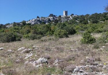
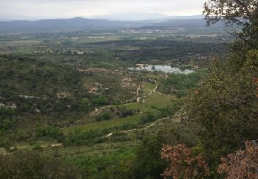
Trail Walking of 14 km to be discovered at Occitania, Hérault, Mas-de-Londres. This trail is proposed by grageot.
Description
*** 6h
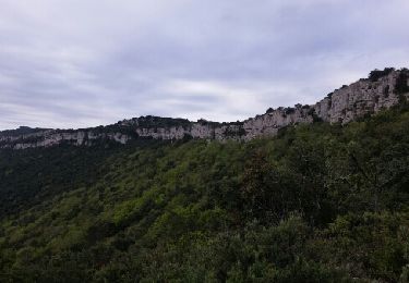
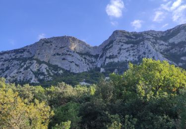
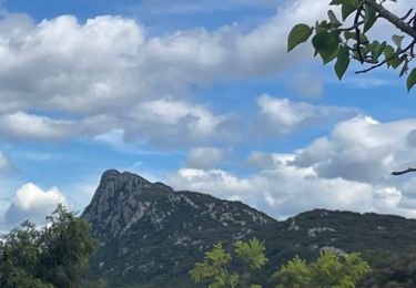
La descente après le Pic et la chapelle est très raide, le marquage (bleu) est quasiment effacé et certain passage sont en bord de failaise. il ne faut aps avoir le vertige.
Positioning
Country:
France
Region :
Occitania
Department/Province :
Hérault
Municipality :
Mas-de-Londres
Location:
Unknown
Start:(Dec)
Start:(UTM)
564857 ; 4848654 (31T) N.
Comments
Trails nearby
![Trail Walking Cazevieille - le tour du pic st loup - Photo](https://media.geolcdn.com/t/375/260/ext.jpg?maxdim=2&url=https%3A%2F%2Fservices.sitytrail.com%2FGeolivesWS%2FDownloadMedia.ashx%3FTrailID%3D564155%26Media%3Dfix__20160505154449.jpg)
![Walking Walking](https://static1.geolcdn.com/sitytour/trail-icons/101.png)
le tour du pic st loup
Walking
Medium
(1)
Cazevieille,
Occitania,
Hérault,
France
![](/images/other/stat-length.png)
11.4 km | 19.8 km-effort
4h 34min
![](https://static1.geolcdn.com/siteimages/upload/files/16400158638029165_repeat_loop_refresh_sync_direction_icon.png)
Yes
![Trail Walking Valflaunès - l hortus - Photo](https://media.geolcdn.com/t/375/260/ext.jpg?maxdim=2&url=https%3A%2F%2Fservices.sitytrail.com%2FGeolivesWS%2FDownloadMedia.ashx%3FTrailID%3D557567%26Media%3Dfix__20160417104921.jpg)
![Walking Walking](https://static1.geolcdn.com/sitytour/trail-icons/101.png)
l hortus
Walking
Medium
(2)
Valflaunès,
Occitania,
Hérault,
France
![](/images/other/stat-length.png)
9.9 km | 15.1 km-effort
2h 26min
![](https://static1.geolcdn.com/siteimages/upload/files/16400158638029165_repeat_loop_refresh_sync_direction_icon.png)
Yes
![Trail Walking Mas-de-Londres - face nord pic Saint Loup - Photo](https://media.geolcdn.com/t/375/260/ext.jpg?maxdim=2&url=https%3A%2F%2Fmedia.geolcdn.com%2Ff%2Fd1059764-52a0-4b94-ba59-729039d80717.jpg)
![Walking Walking](https://static1.geolcdn.com/sitytour/trail-icons/101.png)
face nord pic Saint Loup
Walking
Difficult
Mas-de-Londres,
Occitania,
Hérault,
France
![](/images/other/stat-length.png)
3.8 km | 9.4 km-effort
2h 0min
![](https://static1.geolcdn.com/siteimages/upload/files/16400158638029165_repeat_loop_refresh_sync_direction_icon.png)
Yes
![Trail Walking Mas-de-Londres - LL34-Pic St Loup par arête ouest - Photo](https://media.geolcdn.com/t/375/260/ext.jpg?maxdim=2&url=https%3A%2F%2Fstatic1.geolcdn.com%2Fsiteimages%2Fupload%2Ffiles%2F1553511878bg_sport_marche.png)
![Walking Walking](https://static1.geolcdn.com/sitytour/trail-icons/101.png)
LL34-Pic St Loup par arête ouest
Walking
Medium
(4)
Mas-de-Londres,
Occitania,
Hérault,
France
![](/images/other/stat-length.png)
10.5 km | 17.9 km-effort
5h 10min
![](https://static1.geolcdn.com/siteimages/upload/files/16400158638029165_repeat_loop_refresh_sync_direction_icon.png)
Yes
![Trail Walking Cazevieille - cazevieille-pic st loup-lac fe la jasse - Photo](https://media.geolcdn.com/t/375/260/ext.jpg?maxdim=2&url=https%3A%2F%2Fservices.sitytrail.com%2FGeolivesWS%2FDownloadMedia.ashx%3FTrailID%3D579300%26Media%3Dfix__20160604134108.jpg)
![Walking Walking](https://static1.geolcdn.com/sitytour/trail-icons/101.png)
cazevieille-pic st loup-lac fe la jasse
Walking
Difficult
(2)
Cazevieille,
Occitania,
Hérault,
France
![](/images/other/stat-length.png)
14.7 km | 23 km-effort
5h 21min
![](https://static1.geolcdn.com/siteimages/upload/files/16400158638029165_repeat_loop_refresh_sync_direction_icon.png)
Yes
![Trail Nordic walking Cazevieille - cazevieille + lac de la jasse - Photo](https://media.geolcdn.com/t/375/260/ext.jpg?maxdim=2&url=https%3A%2F%2Fservices.sitytrail.com%2FGeolivesWS%2FDownloadMedia.ashx%3FTrailID%3D565622%26Media%3Dfix__20160508095919.jpg)
![Nordic walking Nordic walking](https://static1.geolcdn.com/sitytour/trail-icons/102.png)
cazevieille + lac de la jasse
Nordic walking
Medium
(1)
Cazevieille,
Occitania,
Hérault,
France
![](/images/other/stat-length.png)
9.5 km | 13.6 km-effort
2h 32min
![](https://static1.geolcdn.com/siteimages/upload/files/16400158638029165_repeat_loop_refresh_sync_direction_icon.png)
Yes
![Trail Walking Mas-de-Londres - La Jasse Cazevieille par l’ubac - Photo](https://media.geolcdn.com/t/375/260/ext.jpg?maxdim=2&url=https%3A%2F%2Fmedia.geolcdn.com%2Ff%2F9a13e1f3-2499-4387-bf75-45d970603d81.jpg)
![Walking Walking](https://static1.geolcdn.com/sitytour/trail-icons/101.png)
La Jasse Cazevieille par l’ubac
Walking
Medium
Mas-de-Londres,
Occitania,
Hérault,
France
![](/images/other/stat-length.png)
12.6 km | 16 km-effort
3h 43min
![](https://static1.geolcdn.com/siteimages/upload/files/16400158638029165_repeat_loop_refresh_sync_direction_icon.png)
Yes
![Trail Walking Notre-Dame-de-Londres - ND-de-Londres_Chutes_Lamalou - Photo](https://media.geolcdn.com/t/375/260/ext.jpg?maxdim=2&url=https%3A%2F%2Fmedia.geolcdn.com%2Ff%2Fcc86ec54-6797-4ec2-b4ff-89965130e43a.jpg)
![Walking Walking](https://static1.geolcdn.com/sitytour/trail-icons/101.png)
ND-de-Londres_Chutes_Lamalou
Walking
Medium
Notre-Dame-de-Londres,
Occitania,
Hérault,
France
![](/images/other/stat-length.png)
11.5 km | 14.2 km-effort
3h 30min
![](https://static1.geolcdn.com/siteimages/upload/files/16400158638029165_repeat_loop_refresh_sync_direction_icon.png)
Yes
![Trail Walking Cazevieille - Pic St Loup + Crête 16.12.23 - Photo](https://media.geolcdn.com/t/375/260/ext.jpg?maxdim=2&url=https%3A%2F%2Fmedia.geolcdn.com%2Ff%2Fbfdaf89a-9773-4f5d-a083-c292c0cb02a4.jpg)
![Walking Walking](https://static1.geolcdn.com/sitytour/trail-icons/101.png)
Pic St Loup + Crête 16.12.23
Walking
Difficult
Cazevieille,
Occitania,
Hérault,
France
![](/images/other/stat-length.png)
6.7 km | 11.6 km-effort
4h 15min
![](https://static1.geolcdn.com/siteimages/upload/files/16400158638029165_repeat_loop_refresh_sync_direction_icon.png)
Yes
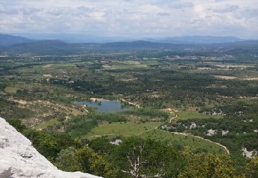
une traversée de la crête du Pic superbe. Ancien balisage point rouge jusqu'au sommet puis points bleus en descente. Rando assez aérienne, possibilité de revenir au point de départ a partir du col