Trail Walking Saint-Côme-d'Olt - Labastide canto messo - Photo

Labastide canto messo

 limo12
limo12

User

© OpenStreetMap contributors
Length
Length
9.3 km
Max alt
Max alt
847 m
Uphill gradient
Uphill gradient
199 m
Km-Effort
Km-Effort  
11.9 km
Min alt
Min alt
724 m
Downhill gradient
Downhill gradient
198 m
Boucle
Boucle
Yes
Creation date :
2020-03-19 13:38:43.898
Updated on :
2020-03-19 15:57:24.054

(0 Reviews)

Walking
Walking
2h18
Difficulty : Easy

Scan this QR Code to open this trail in the SityTrail application

FREE GPS app for hiking

Logo SityTrail SityTrail

IGN / Geographical institutes

Download SityTrail from the App Store Download SityTrail from Google Play

Logo SityTrail SityTrail World

The world is yours!

Download SityTrail from the App Store Download SityTrail from Google Play Download SityTrail on Huawei AppGallery

About

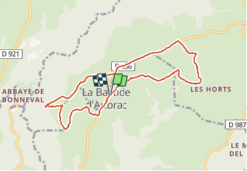
Trail Walking of 9.3 km to be discovered at Occitania, Aveyron, Saint-Côme-d'Olt. This trail is proposed by limo12.

Elevation profile

Photos

Positioning

Country:
France
Region :
Occitania
Department/Province :
Aveyron
Municipality :
Saint-Côme-d'Olt
Location:
Unknown
Start:(UTM)
485400 ; 4934326 (31T) N.

Trails nearby

Trail Walking Espalion - Compostelle 08 - Espalion -> Estaing - Photo
Walking
uru2010

Walking

Easy
(1)
Espalion, Occitania, Aveyron, France
13.8 km | 17.9 km-effort
3h 53min
No
Trail Walking Espalion - Espalion Massip Avril 2018 - Photo
Walking
GUIDE
Kargil

Walking

Difficult
Espalion, Occitania, Aveyron, France
25 km | 35 km-effort
7h 13min
No
Trail Walking Saint-Côme-d'Olt - étape st Jacques st come sur d olt-estaing - Photo
Walking
fab0202

Walking

Medium
Saint-Côme-d'Olt, Occitania, Aveyron, France
25 km | 32 km-effort
5h 54min
No
Trail On foot Condom-d'Aubrac - Sentier Aubrac - Abbaye de Bonneval - Espalion - Photo
On foot
PRO

On foot

Easy
Condom-d'Aubrac, Occitania, Aveyron, France
12.8 km | 19.2 km-effort
4h 21min
No
Trail Walking Espalion - CC_Velay_BD_08_Espalion_Golinhac_20070823 - Photo
Walking
patrickdanilo

Walking

Difficult
Espalion, Occitania, Aveyron, France
28 km | 39 km-effort
7h 30min
No
Trail Walking Saint-Côme-d'Olt - saint Côme d'olt- Estaing - Photo
Walking
guariso

Walking

Difficult
Saint-Côme-d'Olt, Occitania, Aveyron, France
23 km | 31 km-effort
6h 17min
No
Trail Walking Espalion - Mon Compostelle, quatrième étape - Photo
Walking
Ardeiserois

Walking

Very difficult
Espalion, Occitania, Aveyron, France
47 km | 65 km-effort
10h 0min
No
Trail Walking Espalion - espalion - golinhac - Photo
Walking
jib971

Walking

Difficult
Espalion, Occitania, Aveyron, France
29 km | 39 km-effort
8h 42min
No
Trail Cycle Espalion - L'histoire des paysages -  Espalion - Photo
Cycle
tracegps

Cycle

Difficult
Espalion, Occitania, Aveyron, France
64 km | 79 km-effort
4h 19min
Yes


Close
My subscriptions