Trail Walking Pont-à-Celles - En passant de la Meuse à l'Escaut - Photo

En passant de la Meuse à l'Escaut

 MicDul
MicDul

User

© OpenStreetMap contributors
Length
Length
6.3 km
Max alt
Max alt
161 m
Uphill gradient
Uphill gradient
52 m
Km-Effort
Km-Effort  
7 km
Min alt
Min alt
132 m
Downhill gradient
Downhill gradient
52 m
Boucle
Boucle
Yes
Creation date :
2020-05-23 09:44:26.887
Updated on :
2020-11-23 07:17:53.426

(1 Reviews)

Walking
Walking
1h33
Difficulty : Very easy

Scan this QR Code to open this trail in the SityTrail application

FREE GPS app for hiking

Logo SityTrail SityTrail

IGN / Geographical institutes

Download SityTrail from the App Store Download SityTrail from Google Play

Logo SityTrail SityTrail World

The world is yours!

Download SityTrail from the App Store Download SityTrail from Google Play Download SityTrail on Huawei AppGallery

About

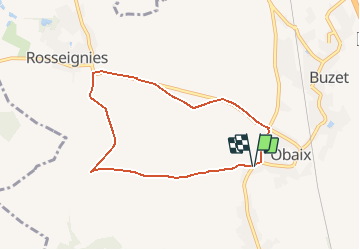
Trail Walking of 6.3 km to be discovered at Wallonia, Hainaut, Pont-à-Celles. This trail is proposed by MicDul.

Description

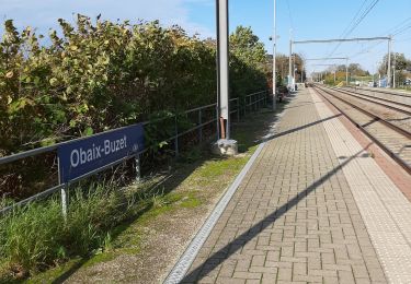
Départ en face du numéro 9 Rue du Village à Obaix.

Elevation profile

Photos

Points of interest

Point of interest Pont-à-Celles - N°9 Rue du Village  - Photo
MicDul
PONT-À-CELLES 
Point of interest Pont-à-Celles - Carrefour, à gauche - Photo
MicDul
PONT-À-CELLES 
Point of interest Pont-à-Celles - Chemin pavé à gauche - Photo
MicDul
PONT-À-CELLES 
Point of interest Pont-à-Celles - Croisement en T, à gauche - Photo
MicDul
Point of interest Pont-à-Celles - A gauche avec la route - Photo
MicDul
PONT-À-CELLES 
Point of interest Pont-à-Celles - Croisement, 1er chemin à gauche - Photo
MicDul
Point of interest Pont-à-Celles - N°9 Rue du Village - Photo
MicDul
PONT-À-CELLES 

Positioning

Country:
Belgium
Region :
Wallonia
Department/Province :
Hainaut
Municipality :
Pont-à-Celles
Location:
Obaix
Start:(UTM)
596051 ; 5598075 (31U) N.

Comments

Please log in to post a review or rate the element


Trails nearby

Trail Walking Pont-à-Celles - Balade verte au Pays noir - Viesville et sa réserve naturelle - Photo
Walking
GUIDE
Desrumaux

Walking

Easy
(7)
Pont-à-Celles, Wallonia, Hainaut, Belgium
10.2 km | 12.6 km-effort
2h 30min
Yes
Trail Walking Chapelle-lez-Herlaimont - GG-HT-07_Godarville-Piéton - Photo
Walking
PRO

Walking

Very difficult
(4)
Chapelle-lez-Herlaimont, Wallonia, Hainaut, Belgium
18.8 km | 22 km-effort
4h 50min
No
Trail Mountain bike Pont-à-Celles - SityTrail - 2716349 - genappe_20210321_082641 - Photo
Mountain bike
GUIDE
pascalou73

Mountain bike

Very easy
Pont-à-Celles, Wallonia, Hainaut, Belgium
49 km | 56 km-effort
Unknown
Yes
Trail Mountain bike Pont-à-Celles - _20201114_091824 - Photo
Mountain bike
GUIDE
pascalou73

Mountain bike

Medium
Pont-à-Celles, Wallonia, Hainaut, Belgium
38 km | 42 km-effort
Unknown
Yes
Trail Mountain bike Les Bons Villers - VTT de Réves - Photo
Mountain bike
GUIDE
pascalou73

Mountain bike

Very easy
Les Bons Villers, Wallonia, Hainaut, Belgium
43 km | 47 km-effort
2h 0min
Yes
Trail Walking Pont-à-Celles - De Pont à Celles à Gouy-lez-Piétons - Photo
Walking
GUIDE
Desrumaux

Walking

Easy
Pont-à-Celles, Wallonia, Hainaut, Belgium
13.6 km | 15.3 km-effort
3h 20min
Yes
Trail Walking Pont-à-Celles - Buzet - Rosseignies - Obaix - Buzet - Photo
Walking
mvrydagh

Walking

Easy
Pont-à-Celles, Wallonia, Hainaut, Belgium
8.7 km | 9.7 km-effort
1h 41min
Yes
Trail Walking Pont-à-Celles - BE-Pont-à-Celles - Autour du ruisseau de Rosseignies - Photo
Walking
MicDul

Walking

Easy
(2)
Pont-à-Celles, Wallonia, Hainaut, Belgium
7.6 km | 8.5 km-effort
1h 49min
Yes
Trail Walking Pont-à-Celles - Marcha / Jean le Boucher / vers Luttre / Eglise Obaix / Moulin / Gare - Photo
Walking
mvrydagh

Walking

Very easy
Pont-à-Celles, Wallonia, Hainaut, Belgium
6.8 km | 7.5 km-effort
1h 33min
Yes


Close
My subscriptions