Trail Walking Broquiès - La Cazotte Le Perayrol - Photo

La Cazotte Le Perayrol

 Rere1947
Rere1947

User

© OpenStreetMap contributors
Length
Length
18.2 km
Max alt
Max alt
502 m
Uphill gradient
Uphill gradient
467 m
Km-Effort
Km-Effort  
24 km
Min alt
Min alt
258 m
Downhill gradient
Downhill gradient
473 m
Boucle
Boucle
Yes
Creation date :
2020-06-24 06:34:40.0
Updated on :
2020-06-24 13:01:46.476

(0 Reviews)

Walking
Walking
6h24
Difficulty : Unknown

Scan this QR Code to open this trail in the SityTrail application

FREE GPS app for hiking

Logo SityTrail SityTrail

IGN / Geographical institutes

Download SityTrail from the App Store Download SityTrail from Google Play

Logo SityTrail SityTrail World

The world is yours!

Download SityTrail from the App Store Download SityTrail from Google Play Download SityTrail on Huawei AppGallery

About

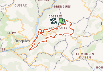
Trail Walking of 18.2 km to be discovered at Occitania, Aveyron, Broquiès. This trail is proposed by Rere1947.

Description

Balade cool avec quelques allers retours dus au chemins fermé

Elevation profile

Photos

Positioning

Country:
France
Region :
Occitania
Department/Province :
Aveyron
Municipality :
Broquiès
Location:
Unknown
Start:(UTM)
479084 ; 4873703 (31T) N.

Trails nearby

Trail Walking Saint-Izaire - st izaire - Photo
Walking
nanie

Walking

Very easy
(1)
Saint-Izaire, Occitania, Aveyron, France
13.1 km | 19.6 km-effort
5h 55min
Yes
Trail Walking Broquiès - Broquiès et la Vallée du Tarn - Photo
Walking
tracegps

Walking

Difficult
Broquiès, Occitania, Aveyron, France
18.9 km | 29 km-effort
5h 45min
Yes
Trail Walking Le Truel - la Sabaterie reco - Photo
Walking
sergedurand

Walking

Difficult
Le Truel, Occitania, Aveyron, France
11.5 km | 15.7 km-effort
4h 51min
Yes
Trail Walking Le Truel - brousse le château  - Photo
Walking
tosan

Walking

Very difficult
Le Truel, Occitania, Aveyron, France
19.8 km | 28 km-effort
9h 4min
No
Trail Walking Saint-Izaire - Saint Izaire - Photo
Walking
Frayssinet

Walking

Very difficult
Saint-Izaire, Occitania, Aveyron, France
19.5 km | 29 km-effort
6h 37min
Yes
Trail Walking Saint-Izaire - st izaire douce - Photo
Walking
CASSISFRAMBOISE

Walking

Easy
Saint-Izaire, Occitania, Aveyron, France
8.5 km | 12 km-effort
1h 55min
Yes
Trail Walking Le Truel - de truel au viala du tarn in live - Photo
Walking
CASSISFRAMBOISE

Walking

Difficult
Le Truel, Occitania, Aveyron, France
21 km | 32 km-effort
5h 7min
No
Trail Walking Saint-Izaire - Saint izaire  2023 - Photo
Walking
Frayssinet

Walking

Very difficult
Saint-Izaire, Occitania, Aveyron, France
22 km | 32 km-effort
7h 11min
Yes
Trail Walking Saint-Victor-et-Melvieu - rando du bosq le truel - Photo
Walking
Pascal Lemaire

Walking

Medium
Saint-Victor-et-Melvieu, Occitania, Aveyron, France
8.3 km | 12.2 km-effort
2h 41min
Yes


Close
My subscriptions