


Sentier des méandres

lepompi
User
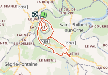

Length
6.9 km

Max alt
161 m

Uphill gradient
155 m
Km-Effort
9 km

Min alt
56 m

Downhill gradient
155 m
Boucle
Yes
Creation date :
2020-09-07 07:01:52.901
Updated on :
2020-09-13 05:02:27.085
2h09
Difficulty : Easy

FREE GPS app for hiking
 SityTrail
IGN / Geographical institutes
SityTrail Plus
The world is yours!
About
Trail Walking of 6.9 km to be discovered at Normandy, Orne, Ménil-Hubert-sur-Orne. This trail is proposed by lepompi.
Description
attendre levée de la brume avant de partir. Tronc commun avec autre rando.
Superbes paysages.
Positioning
Country:
France
Region :
Normandy
Department/Province :
Orne
Municipality :
Ménil-Hubert-sur-Orne
Location:
Unknown
Start:(Dec)
Start:(UTM)
690980 ; 5413071 (30U) N.
Comments