


entre Orne et Rouvre (6)

lepompi
User
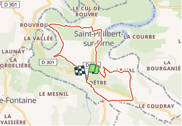

Length
8.3 km

Max alt
185 m

Uphill gradient
206 m
Km-Effort
11 km

Min alt
79 m

Downhill gradient
204 m
Boucle
Yes
Creation date :
2020-09-09 06:27:27.216
Updated on :
2020-09-13 04:58:15.753
2h20
Difficulty : Medium

FREE GPS app for hiking
 SityTrail
IGN / Geographical institutes
SityTrail Plus
The world is yours!
About
Trail Walking of 8.3 km to be discovered at Normandy, Orne, Saint-Philbert-sur-Orne. This trail is proposed by lepompi.
Positioning
Country:
France
Region :
Normandy
Department/Province :
Orne
Municipality :
Saint-Philbert-sur-Orne
Location:
Unknown
Start:(Dec)
Start:(UTM)
692198 ; 5411813 (30U) N.
Comments