![](/images/other/stat-length.png)
![Trail Walking Bormes-les-Mimosas - Boucle : Pont des Caunes - Piste de l'Amandier - Piste de la Gourre - Piste Lambert - Col de la Citadelle - Pont des Caunes. - Photo](https://media.geolcdn.com/t/1900/400/ext.pjpeg?maxdim=2&url=https%3A%2F%2Fmedia.geolcdn.com%2Ff%2F93e7f835-4806-4284-8793-c12d2410b0fc.jpg)
Boucle : Pont des Caunes - Piste de l'Amandier - Piste de la Gourre - Piste Lambert - Col de la Citadelle - Pont des Caunes.
affinetataille
User GUIDE
![Length](/images/other/stat-length.png)
Length
15.1 km
![Max alt](https://static1.geolcdn.com/siteimages/upload/files/1508320355ic_sort_altitude_max_24dp.png)
Max alt
461 m
![Uphill gradient](https://static1.geolcdn.com/siteimages/upload/files/1508320355ic_sort_den_pos_24dp.png)
Uphill gradient
468 m
![Km-Effort](/images/other/stat-length.png)
Km-Effort
21 km
![Min alt](https://static1.geolcdn.com/siteimages/upload/files/1508320355ic_sort_altitude_min_24dp.png)
Min alt
92 m
![Downhill gradient](https://static1.geolcdn.com/siteimages/upload/files/1508320355ic_sort_den_neg_24dp.png)
Downhill gradient
466 m
![Boucle](https://static1.geolcdn.com/siteimages/upload/files/16400158638029165_repeat_loop_refresh_sync_direction_icon.png)
Boucle
Yes
Creation date :
2020-09-17 08:27:19.381
Updated on :
2020-09-17 18:30:36.483
![Walking](https://static1.geolcdn.com/sitytour/trail-icons/101.png)
5h06
Difficulty : Medium
![Scan this QR Code to open this trail in the SityTrail application](https://capi.geolives.com/qq0zvz2zws4bq2lad0pu/sitytour/trails/2553725/qr.png?size=200)
FREE GPS app for hiking
About
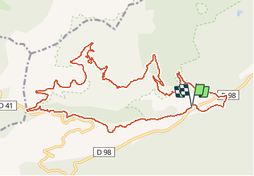
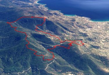
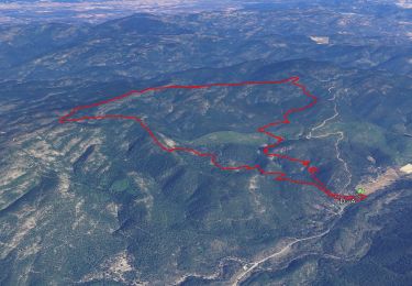
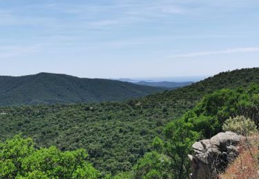
Trail Walking of 15.1 km to be discovered at Provence-Alpes-Côte d'Azur, Var, Bormes-les-Mimosas. This trail is proposed by affinetataille.
Description
Randonnée sans aucune difficulté.
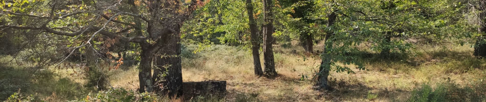
Pas très ombragée.
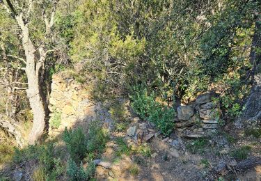
Ruisseaux à sec en cette période (septembre) dommage, pas de cascades.
Positioning
Country:
France
Region :
Provence-Alpes-Côte d'Azur
Department/Province :
Var
Municipality :
Bormes-les-Mimosas
Location:
Unknown
Start:(Dec)
Start:(UTM)
285856 ; 4785150 (32T) N.
Comments
Trails nearby
![Trail Walking Bormes-les-Mimosas - Les vallons de Valcros - Photo](https://media.geolcdn.com/t/375/260/ext.jpg?maxdim=2&url=https%3A%2F%2Fmedia.geolcdn.com%2Ff%2F34bfd198-10be-46eb-9da0-abc362c3aac8.JPG)
![Walking Walking](https://static1.geolcdn.com/sitytour/trail-icons/101.png)
Les vallons de Valcros
Walking
Difficult
(2)
Bormes-les-Mimosas,
Provence-Alpes-Côte d'Azur,
Var,
France
![](/images/other/stat-length.png)
14 km | 22 km-effort
6h 0min
![](https://static1.geolcdn.com/siteimages/upload/files/16400158638029165_repeat_loop_refresh_sync_direction_icon.png)
Yes
![Trail Walking Bormes-les-Mimosas - SityTrail - Bormes les Mimosas - ND de Constance - Cols de Gratteloup et Landon - Photo](https://media.geolcdn.com/t/375/260/ext.jpg?maxdim=2&url=https%3A%2F%2Fmedia.geolcdn.com%2Ff%2Fc3cd69d2-66a0-450a-95c5-e8005107dd21.jpg)
![Walking Walking](https://static1.geolcdn.com/sitytour/trail-icons/101.png)
SityTrail - Bormes les Mimosas - ND de Constance - Cols de Gratteloup et Landon
Walking
Difficult
(1)
Bormes-les-Mimosas,
Provence-Alpes-Côte d'Azur,
Var,
France
![](/images/other/stat-length.png)
13.4 km | 21 km-effort
5h 48min
![](https://static1.geolcdn.com/siteimages/upload/files/16400158638029165_repeat_loop_refresh_sync_direction_icon.png)
Yes
![Trail Walking Bormes-les-Mimosas - SityTrail - 3043274 - bargeanxchartreuse-verne - Photo](https://media.geolcdn.com/t/375/260/ext.jpg?maxdim=2&url=https%3A%2F%2Fmedia.geolcdn.com%2Ff%2F3db88ff5-5d2e-4949-8a29-14c430fd8c8f.jpg)
![Walking Walking](https://static1.geolcdn.com/sitytour/trail-icons/101.png)
SityTrail - 3043274 - bargeanxchartreuse-verne
Walking
Medium
(1)
Bormes-les-Mimosas,
Provence-Alpes-Côte d'Azur,
Var,
France
![](/images/other/stat-length.png)
15.2 km | 23 km-effort
6h 0min
![](https://static1.geolcdn.com/siteimages/upload/files/16400158638029165_repeat_loop_refresh_sync_direction_icon.png)
Yes
![Trail Walking Bormes-les-Mimosas - Chartreuse de la Verne - Photo](https://media.geolcdn.com/t/375/260/ext.jpg?maxdim=2&url=https%3A%2F%2Fservices.sitytrail.com%2FGeolivesWS%2FDownloadMedia.ashx%3FTrailID%3D898630%26Media%3Dfix__20170215102107.jpg)
![Walking Walking](https://static1.geolcdn.com/sitytour/trail-icons/101.png)
Chartreuse de la Verne
Walking
Difficult
(2)
Bormes-les-Mimosas,
Provence-Alpes-Côte d'Azur,
Var,
France
![](/images/other/stat-length.png)
19.3 km | 31 km-effort
6h 26min
![](https://static1.geolcdn.com/siteimages/upload/files/16400158638029165_repeat_loop_refresh_sync_direction_icon.png)
Yes
![Trail Walking Bormes-les-Mimosas - Bormes les Mimosas et la Forêt des Maures - Photo](https://media.geolcdn.com/t/375/260/ext.jpg?maxdim=2&url=https%3A%2F%2Fservices.sitytrail.com%2FGeolivesWS%2FDownloadMedia.ashx%3FTrailID%3D103786%26Media%3D6556_2.jpg)
![Walking Walking](https://static1.geolcdn.com/sitytour/trail-icons/101.png)
Bormes les Mimosas et la Forêt des Maures
Walking
Medium
(2)
Bormes-les-Mimosas,
Provence-Alpes-Côte d'Azur,
Var,
France
![](/images/other/stat-length.png)
14 km | 22 km-effort
4h 15min
![](https://static1.geolcdn.com/siteimages/upload/files/16400158638029165_repeat_loop_refresh_sync_direction_icon.png)
Yes
![Trail Walking Bormes-les-Mimosas - Col du Gratteloup - Piste domaniale Sud - Cols de Labade et Landon - Pierre d'Avenon - GR51/90 - Photo](https://media.geolcdn.com/t/375/260/ext.jpg?maxdim=2&url=https%3A%2F%2Fmedia.geolcdn.com%2Ff%2Fa68a068d-d9c5-4471-8f2a-bbfabcb93eed.jpg)
![Walking Walking](https://static1.geolcdn.com/sitytour/trail-icons/101.png)
Col du Gratteloup - Piste domaniale Sud - Cols de Labade et Landon - Pierre d...
Walking
Easy
(1)
Bormes-les-Mimosas,
Provence-Alpes-Côte d'Azur,
Var,
France
![](/images/other/stat-length.png)
15.1 km | 21 km-effort
6h 0min
![](https://static1.geolcdn.com/siteimages/upload/files/16400158638029165_repeat_loop_refresh_sync_direction_icon.png)
Yes
![Trail Walking Le Lavandou - cavaliere - Photo](https://media.geolcdn.com/t/375/260/ext.jpg?maxdim=2&url=https%3A%2F%2Fstatic1.geolcdn.com%2Fsiteimages%2Fupload%2Ffiles%2F1553511878bg_sport_marche.png)
![Walking Walking](https://static1.geolcdn.com/sitytour/trail-icons/101.png)
cavaliere
Walking
Medium
(1)
Le Lavandou,
Provence-Alpes-Côte d'Azur,
Var,
France
![](/images/other/stat-length.png)
17.8 km | 28 km-effort
6h 59min
![](https://static1.geolcdn.com/siteimages/upload/files/16400158638029165_repeat_loop_refresh_sync_direction_icon.png)
Yes
![Trail Walking Bormes-les-Mimosas - Vallons de la Gourre et des Caunes - Photo](https://media.geolcdn.com/t/375/260/ext.jpg?maxdim=2&url=https%3A%2F%2Fmedia.geolcdn.com%2Ff%2F1e74f8dd-3531-46df-bd25-c87eb6eff58d.jpg)
![Walking Walking](https://static1.geolcdn.com/sitytour/trail-icons/101.png)
Vallons de la Gourre et des Caunes
Walking
Difficult
Bormes-les-Mimosas,
Provence-Alpes-Côte d'Azur,
Var,
France
![](/images/other/stat-length.png)
13.4 km | 18.8 km-effort
4h 16min
![](https://static1.geolcdn.com/siteimages/upload/files/16400158638029165_repeat_loop_refresh_sync_direction_icon.png)
Yes
![Trail Walking Bormes-les-Mimosas - Forêt du Dom - Photo](https://media.geolcdn.com/t/375/260/ext.jpg?maxdim=2&url=https%3A%2F%2Fmedia.geolcdn.com%2Ff%2F841c4ef1-7709-4d94-8f70-350221799c2e.jpg)
![Walking Walking](https://static1.geolcdn.com/sitytour/trail-icons/101.png)
Forêt du Dom
Walking
Very difficult
(1)
Bormes-les-Mimosas,
Provence-Alpes-Côte d'Azur,
Var,
France
![](/images/other/stat-length.png)
18.7 km | 27 km-effort
6h 5min
![](https://static1.geolcdn.com/siteimages/upload/files/16400158638029165_repeat_loop_refresh_sync_direction_icon.png)
Yes