Trail Walking Plainfaing - Le Bonhomme (col du) 19 380 +924m - Photo

Le Bonhomme (col du) 19 380 +924m

© OpenStreetMap contributors
Length
Length
19.4 km
Max alt
Max alt
1236 m
Uphill gradient
Uphill gradient
925 m
Km-Effort
Km-Effort  
32 km
Min alt
Min alt
685 m
Downhill gradient
Downhill gradient
926 m
Boucle
Boucle
Yes
Creation date :
2020-10-19 08:23:53.158
Updated on :
2020-10-20 08:04:03.234

(0 Reviews)

Walking
Walking
6h20
Difficulty : Difficult

Scan this QR Code to open this trail in the SityTrail application

FREE GPS app for hiking

Logo SityTrail SityTrail

IGN / Geographical institutes

Download SityTrail from the App Store Download SityTrail from Google Play

Logo SityTrail SityTrail World

The world is yours!

Download SityTrail from the App Store Download SityTrail from Google Play Download SityTrail on Huawei AppGallery

About

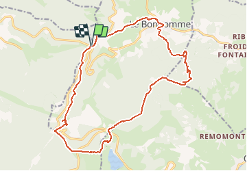
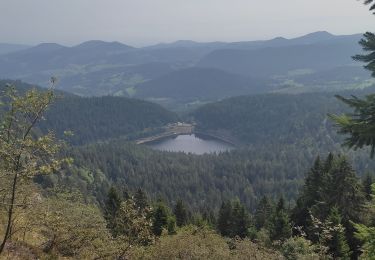
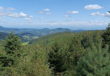
Trail Walking of 19.4 km to be discovered at Grand Est, Vosges, Plainfaing. This trail is proposed by DanielROLLET.

Description

2020 10 19 - 09:45 à 16:05 - Beau temps mais frais.
Avec Marie et Henri
Parcouru 20 300m avec les erreurs et visites.

Elevation profile

Positioning

Country:
France
Region :
Grand Est
Department/Province :
Vosges
Municipality :
Plainfaing
Location:
Unknown
Start:(UTM)
357203 ; 5336415 (32U) N.

Trails nearby

Trail Walking Orbey - Le Tour du Lac Blanc par le Rocher Hans et le sentier de crête - Photo
Walking
tracegps

Walking

Difficult
(3)
Orbey, Grand Est, Haut-Rhin, France
4.4 km | 7.7 km-effort
2h 30min
Yes
Trail Walking Le Bonhomme - Tête des faux . - Photo
Walking
heurtinpatrick

Walking

Medium
(1)
Le Bonhomme, Grand Est, Haut-Rhin, France
11.9 km | 16.6 km-effort
3h 46min
Yes
Trail Mountain bike Orbey - Lac Blanc  - Têtes des Faux - Photo
Mountain bike
tracegps

Mountain bike

Medium
(1)
Orbey, Grand Est, Haut-Rhin, France
15.3 km | 21 km-effort
1h 0min
Yes
Trail Walking Le Bonhomme - Le Bonhomme - Circuit du village - Photo
Walking
GUIDE
Desrumaux

Walking

Easy
(1)
Le Bonhomme, Grand Est, Haut-Rhin, France
3 km | 5.3 km-effort
1h 30min
Yes
Trail Walking Orbey - 2022-07-23 Marche Lacs Blanc Noir Forlet - Photo
Walking
GUIDE
holtzv

Walking

Medium
Orbey, Grand Est, Haut-Rhin, France
16.2 km | 26 km-effort
5h 57min
Yes
Trail Walking Sainte-Marie-aux-Mines - 2021-02-14 Marche Bagenelles Brezouard Fuste de Etoile - Photo
Walking
GUIDE
holtzv

Walking

Very difficult
Sainte-Marie-aux-Mines, Grand Est, Haut-Rhin, France
17.1 km | 27 km-effort
6h 6min
Yes
Trail Walking Lapoutroie - 2020-07-19 Marche Étang du Devin Col Calvaire Tête des Faux - Photo
Walking
GUIDE
holtzv

Walking

Very easy
Lapoutroie, Grand Est, Haut-Rhin, France
14.2 km | 22 km-effort
3h 27min
Yes
Trail Walking Orbey - Col du Calvaire ➡️ Lac Blanc  - Photo
Walking
nana1643

Walking

Medium
Orbey, Grand Est, Haut-Rhin, France
8.6 km | 12.8 km-effort
3h 9min
Yes
Trail Electric bike Le Bonhomme - Lac blanc col de la schlucht Six fours lac noir - Photo
Electric bike
apa

Electric bike

Medium
Le Bonhomme, Grand Est, Haut-Rhin, France
39 km | 49 km-effort
2h 57min
Yes


Close
My subscriptions