Trail On foot Grindelwald - Randonnée au-dessus de Grindelwald - Photo
© OpenStreetMap contributors
Length
Length
10.5 km
Max alt
Max alt
2310 m
Uphill gradient
Uphill gradient
1204 m
Km-Effort
Km-Effort  
27 km
Min alt
Min alt
1231 m
Downhill gradient
Downhill gradient
1204 m
Boucle
Boucle
Yes
Creation date :
2021-01-31 13:24:29.121
Updated on :
2021-01-31 13:37:15.551

(0 Reviews)

On foot
On foot
--
Difficulty : Medium

Scan this QR Code to open this trail in the SityTrail application

FREE GPS app for hiking

Logo SityTrail SityTrail

IGN / Geographical institutes

Download SityTrail from the App Store Download SityTrail from Google Play

Logo SityTrail SityTrail World

The world is yours!

Download SityTrail from the App Store Download SityTrail from Google Play Download SityTrail on Huawei AppGallery

About

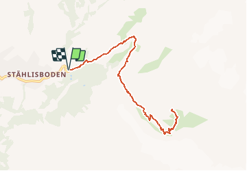
Trail On foot of 10.5 km to be discovered at Bern, Interlaken-Oberhasli administrative district, Grindelwald. This trail is proposed by Zoé Hebinger.

Description

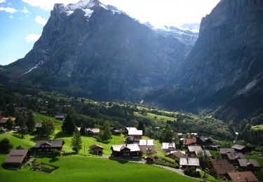
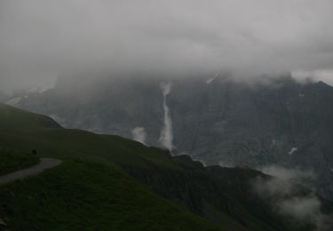
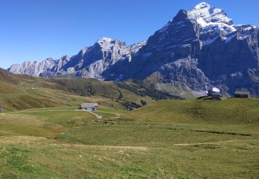
Randonnée au-dessus de Grindelwald du parking de Stählisboden au refuge de Glecksteinhutte. Vue imprenable sur des glaciers.
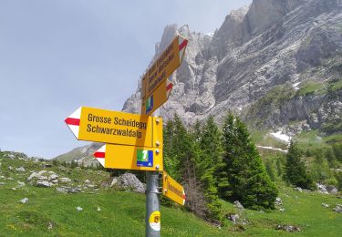
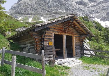
Super balade à faire a pied mais trop technique voir dangereuse à faire en mono.

Elevation profile

Positioning

Country:
Switzerland
Region :
Bern
Department/Province :
Interlaken-Oberhasli administrative district
Municipality :
Grindelwald
Location:
Unknown
Start:(UTM)
428896 ; 5164712 (32T) N.

Trails nearby

Trail On foot Grindelwald - CH-Abzweigung Gleckstein - Glecksteinhütte - Photo
On foot
PRO

On foot

Easy
Grindelwald, Bern, Interlaken-Oberhasli administrative district, Switzerland
4.4 km | 12.8 km-effort
2h 54min
No
Trail On foot Grindelwald - CH-Unterlauchbühl - Bort - Photo
On foot
PRO

On foot

Easy
Grindelwald, Bern, Interlaken-Oberhasli administrative district, Switzerland
4.2 km | 7 km-effort
1h 35min
No
Trail On foot Grindelwald - Bachalpsee - Oberläger - Faulhorn - Photo
On foot
PRO

On foot

Easy
Grindelwald, Bern, Interlaken-Oberhasli administrative district, Switzerland
7.7 km | 16.5 km-effort
3h 45min
No
Trail On foot Grindelwald - Holewang - fixme - Photo
On foot
PRO

On foot

Easy
Grindelwald, Bern, Interlaken-Oberhasli administrative district, Switzerland
5.1 km | 7.5 km-effort
1h 41min
No
Trail On foot Grindelwald - Scheidegg / Oberläger - Wildgärst - Photo
On foot
PRO

On foot

Easy
Grindelwald, Bern, Interlaken-Oberhasli administrative district, Switzerland
8.4 km | 19.1 km-effort
4h 19min
No
Trail On foot Grindelwald - Grosse Scheidegg - Scheidegg / Oberläger - Photo
On foot
PRO

On foot

Easy
Grindelwald, Bern, Interlaken-Oberhasli administrative district, Switzerland
5 km | 6.7 km-effort
1h 31min
No
Trail On foot Grindelwald - Grosse Scheidegg - Schreckfeld - Photo
On foot
PRO

On foot

Easy
Grindelwald, Bern, Interlaken-Oberhasli administrative district, Switzerland
5.2 km | 8.8 km-effort
2h 0min
No
Trail On foot Grindelwald - First - Grosse Scheidegg (Höhenweg 2400) - Photo
On foot
PRO

On foot

Easy
Grindelwald, Bern, Interlaken-Oberhasli administrative district, Switzerland
8.3 km | 15.3 km-effort
3h 28min
No
Trail Walking Grindelwald - Lacs de Bashsee - Photo
Walking
dudu42

Walking

Medium
Grindelwald, Bern, Interlaken-Oberhasli administrative district, Switzerland
11.4 km | 16.9 km-effort
3h 15min
Yes


Close
My subscriptions