


autour de Rabodange

albers
User
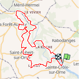

Length
22 km

Max alt
238 m

Uphill gradient
571 m
Km-Effort
29 km

Min alt
64 m

Downhill gradient
569 m
Boucle
Yes
Creation date :
2014-12-10 00:00:00.0
Updated on :
2014-12-10 00:00:00.0
5h00
Difficulty : Medium

FREE GPS app for hiking
 SityTrail
IGN / Geographical institutes
SityTrail Plus
The world is yours!
About
Trail Walking of 22 km to be discovered at Normandy, Orne, Putanges-le-Lac. This trail is proposed by albers.
Positioning
Country:
France
Region :
Normandy
Department/Province :
Orne
Municipality :
Putanges-le-Lac
Location:
Les Rotours
Start:(Dec)
Start:(UTM)
699430 ; 5406921 (30U) N.
Comments