Trail Walking Chatte - Le Tour des Chapelles - Photo

Le Tour des Chapelles

© OpenStreetMap contributors
Length
Length
11.9 km
Max alt
Max alt
453 m
Uphill gradient
Uphill gradient
368 m
Km-Effort
Km-Effort  
16.8 km
Min alt
Min alt
286 m
Downhill gradient
Downhill gradient
368 m
Boucle
Boucle
Yes
Creation date :
2021-05-12 07:03:45.478
Updated on :
2021-05-12 07:04:25.18

(0 Reviews)

Walking
Walking
3h50
Difficulty : Medium

Scan this QR Code to open this trail in the SityTrail application

FREE GPS app for hiking

Logo SityTrail SityTrail

IGN / Geographical institutes

Download SityTrail from the App Store Download SityTrail from Google Play

Logo SityTrail SityTrail World

The world is yours!

Download SityTrail from the App Store Download SityTrail from Google Play Download SityTrail on Huawei AppGallery

About

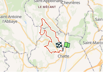
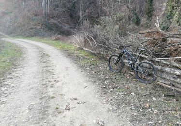
Trail Walking of 11.9 km to be discovered at Auvergne-Rhône-Alpes, Isère, Chatte. This trail is proposed by neoroll44.

Description

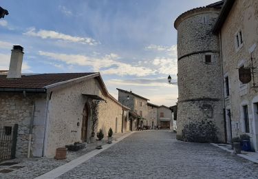
Le Pays de Saint-Marcellin vous offre une escapade champêtre, une promenade entre collines et vallons. Prenez le temps d’admirer ces paysages et ce patrimoine qui s’offre à vous.Garez-vous sur le parking de l'église du village de Chatte. Prendre la direction La Galicière, puis Saint Just, Sainte Philomène, Grand Bois, Chapelle Saint Pierre. Retour à Chatte en passant par Jacquemont, Fond Cotte et la Galicière. Vous découvrirez la chapelle du cimetière, le jardin ferroviaire, et la chapelle Sainte Philomène avec sa table d’orientation. La Galicière, une ancienne usine de moulinage de la soie située à Chatte qui se visite sur réservation.

Elevation profile

Points of interest

Point of interest Chatte - Départ - Photo
neoroll44
CHATTE 

Positioning

Country:
France
Region :
Auvergne-Rhône-Alpes
Department/Province :
Isère
Municipality :
Chatte
Location:
Unknown
Start:(UTM)
679312 ; 5001788 (31T) N.

Trails nearby

Trail Walking Beauvoir-en-Royans - Sentier Martin Pêcheur la Roseliere - Photo
Walking
psesjs

Walking

Very easy
(1)
Beauvoir-en-Royans, Auvergne-Rhône-Alpes, Isère, France
1.2 km | 1.4 km-effort
31min
Yes
Trail Nordic walking Beauvoir-en-Royans - Reconnaissance de Beauvoir-en-Royans à la Sône - Photo
Nordic walking
Emelle

Nordic walking

Medium
Beauvoir-en-Royans, Auvergne-Rhône-Alpes, Isère, France
16.9 km | 22 km-effort
Unknown
Yes
Trail Running Beauvoir-en-Royans - Serre Cocu de Beauvoir - Photo
Running
nadd73

Running

Medium
Beauvoir-en-Royans, Auvergne-Rhône-Alpes, Isère, France
14.1 km | 24 km-effort
2h 19min
Yes
Trail Mountain bike Chatte - De Chatte à St Antoine en passant par Chevrière - Photo
Mountain bike
gilder89

Mountain bike

Very difficult
(1)
Chatte, Auvergne-Rhône-Alpes, Isère, France
44 km | 60 km-effort
3h 53min
Yes
Trail Walking Saint-Antoine l'Abbaye - saint Antoine l abbaye - Photo
Walking
nano38

Walking

Very easy
(1)
Saint-Antoine l'Abbaye, Auvergne-Rhône-Alpes, Isère, France
6.9 km | 9.3 km-effort
1h 52min
Yes
Trail Road bike Chatte - chatte2 - Photo
Road bike
BELLETGE

Road bike

Very easy
(1)
Chatte, Auvergne-Rhône-Alpes, Isère, France
57 km | 71 km-effort
3h 18min
Yes
Trail Nordic walking Beauvoir-en-Royans - MN de Beauvoir en Royans au pont de Beauvoir en passant pas le Pont de la Sône - Photo
Nordic walking
Emelle

Nordic walking

Medium
Beauvoir-en-Royans, Auvergne-Rhône-Alpes, Isère, France
14.2 km | 17.2 km-effort
4h 17min
No
Trail Mountain bike Chatte - chemin du tram part1 - Photo
Mountain bike
Julien Rodriguez

Mountain bike

Very easy
Chatte, Auvergne-Rhône-Alpes, Isère, France
11.4 km | 14.1 km-effort
1h 16min
Yes
Trail Walking Saint-Romans - petite rando entre st romans et st André en royans  - Photo
Walking
popo38

Walking

Easy
Saint-Romans, Auvergne-Rhône-Alpes, Isère, France
10 km | 13.3 km-effort
1h 52min
Yes


Close
My subscriptions