


Face (61)

Eve - Line
User

Length
24 km

Max alt
292 m

Uphill gradient
507 m
Km-Effort
31 km

Min alt
151 m

Downhill gradient
508 m
Boucle
Yes
Creation date :
2021-05-18 07:36:11.959
Updated on :
2021-05-18 13:32:53.681
5h27
Difficulty : Medium

FREE GPS app for hiking
 SityTrail
IGN / Geographical institutes
SityTrail Plus
The world is yours!
About
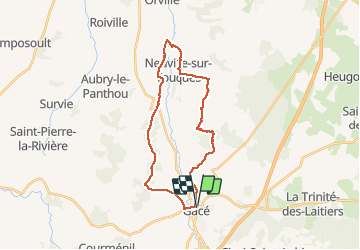
Trail Walking of 24 km to be discovered at Normandy, Orne, Gacé. This trail is proposed by Eve - Line.
Positioning
Country:
France
Region :
Normandy
Department/Province :
Orne
Municipality :
Gacé
Location:
Unknown
Start:(Dec)
Start:(UTM)
301419 ; 5408291 (31U) N.
Comments